"Sandy Ghost Island" appearing on the map is a mistake
A ghost island in the Pacific Ocean that has appeared on many world maps for at least a decade is a mistake, and the confusion dates back to 1876, New Zealand Auckland museum employee Sean Higgins said on December 3.
Previously, Australian scientists from the Southern Surveyor search team, whose mission is to identify emerging landmasses in Oceania due to geological fluctuations, also confirmed that the ghost island appearing on Google Earth and some world maps does not exist in reality.
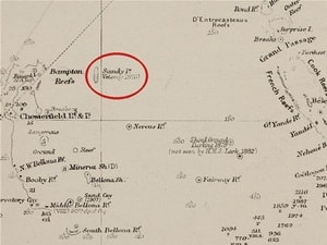
Location of Sandy Island (red circle) on the British Admiralty map (1908). (Source: Auckland Museum)
“The island was on Google Earth and on many other maps,” said Dr. Maria Seton, a member of the expedition team. “So we wanted to check it out. We were puzzled because it didn’t exist. If it didn’t exist, why would they put it on the map?”
On December 3, in a radio program on ABC, New Zealand geographers revealed the reason for the confusion. They said that the ghost island was first put on the world map by the whale hunting ship Velocity.
Previously, it was believed that in 1876, the crew of the ship Velocity had settled on the island because they discovered that ships traveling in this area were very dangerous. Therefore, they later recorded the danger warnings and the location of this island on the map. However, perhaps they had determined the coordinates wrong.
According to the report, when Australian scientists arrived at this exact location, they only saw the vast turquoise color of the Coral Sea. The marine instruments recorded that at that time Dr. Seton’s exploration ship was standing in the sea at a depth of 1,400 meters and there were no islands./.
According to (Vietnam+) - VT


