Development of low pressure areas at sea
(Baonghean.vn) - Last night (August 6), the tropical convergence zone connecting with the low pressure area was located at 1:00 a.m. this morning (August 7) at about 14.5-15.5 degrees North latitude; 114.0-115.0 degrees East longitude, about 320-380km southeast of Hoang Sa archipelago.
Forecast for the next 24 hours,low pressure areas move little andhave the potential to become stronger. At 01:00 on August 8, the center of the low pressure area was at about 15.0-16.0 degrees North latitude; 114.0-115.0 degrees East longitude, about 270-320km East Southeast of Hoang Sa archipelago and was not yet capable of causing strong winds and heavy rains on the mainland of the northern provinces.
Due to the influence of the low pressure area, during the day and tonight (August 7), in the central area of the East Sea (including the waters of Hoang Sa archipelago), there will be showers and heavy thunderstorms, with strong gusts of wind at level 8.
Due to the influence of the tropical convergence zone combined with the strong southwest monsoon, today and tonight, in the central and southern East Sea (including the waters of Truong Sa archipelago), the sea from Binh Thuan to Ca Mau will have strong southwest winds at level 6, gusting to level 8, waves from 2-4m high; rough seas.
The South China Sea (including the Truong Sa archipelago), the sea areas from Binh Thuan to Ca Mau, Ca Mau to Kien Giang and the Gulf of Thailand will have heavy thunderstorms. There is a possibility of tornadoes and strong gusts of wind during thunderstorms.Disaster risk level due to strong winds and big waves: level 1.
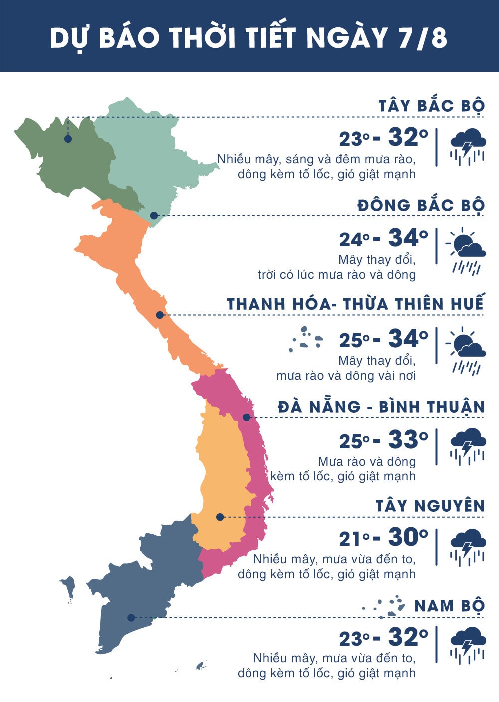 |
| Temperature on August 7 in regions across the country. Photo: news.zing.vn |
FLASH FLOOD, LANDSLIDES AND FLOODING WARNING
GIA LAI, KON TUM
In the past 1-4 hours, some places in Gia Lai and Kon Tum have had heavy to very heavy rain. Rainfall at some stations is as follows: Plei Kan: 45mm, Ia Toi commune: 51.6mm, Mit Kom II village, Ia O: 66.8mm, Se San 4 hydropower plant: 76.6mm.
In the next 3 hours, this area will continue to have moderate rain, heavy rain, and in some places very heavy rain with rainfall from 30-60mm.
Warning:In the next 3-6 hours, there is a high risk of flash floods, landslides on small rivers and streams in mountainous areas and localized flooding in low-lying areas in Gia Lai and Kon Tum provinces, especially Ia Grai districts (Gia Lai); Ngoc Hoi, Ia H'Drai (Kon Tum).Disaster risk level: Level 1.
LAO CAI, YEN BAI
In the past 3 hours, from 2am to 5am on August 7, there was very heavy rain in Lao Cai and Yen Bai provinces. Rainfall measured at some stations in Lao Cai province such as: Bac Ha Hydropower Plant (Bac Ha district): 27.4mm; Seo Chong Ho Hydropower Plant (Sa Pa district): 24.8mm; and some stations in Yen Bai province such as: Tan Dong (Tran Yen district): 58.8mm; Co Phuc (Tran Yen district): 36.4mm.
Comments:In the next 1-3 hours, in Lao Cai province in Bac Ha and Sa Pa districts and Yen Bai province in Tran Yen district, there will continue to be moderate rain, with some places having heavy rain with rainfall of about 20-50mm.
Warning:In the next 3-6 hours, flash floods and landslides are at risk in Bac Ha and Sa Pa districts of Lao Cai province and Tran Yen district of Yen Bai province.