Weather forecast September 16: Northern region has level 9 wind gusts, preparing for storm
According to the weather forecast for today, September 16, according to the Center for Hydrometeorology, the Northeast region is warned of changing clouds, scattered showers and thunderstorms; coastal areas from tomorrow evening will have rain, some places will have moderate rain, heavy rain and scattered thunderstorms. North to northwest winds will be level 2 - 3, coastal provinces from Quang Ninh to Nam Dinh from tomorrow evening will have winds gradually increasing to level 6 - 7, near the storm center level 8 - 9, gusting to level 10 - 11.
The highest temperature in the country is from 28 to 34 degrees Celsius. The weather is relatively cool.
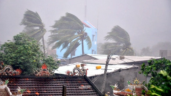 |
| Northeast wind gusts at level 9, preparing for storm. Illustrative photo |
Storm news number 3:
At 4:00 a.m. on September 16, the center of the storm was located at about 19.4 degrees North latitude; 112.2 degrees East longitude, in the sea east of Hainan Island (China), about 570km East Southeast of the coast of Hai Phong - Quang Ninh. The strongest wind near the center of the storm was at level 12, level 13 (ie from 118 to 149km per hour), gusting to level 15, level 16.
It is forecasted that in the next 12 hours, the storm will move in the West Northwest direction, traveling about 25 - 30km per hour. So this afternoon (September 16), the storm center will enter the northern sea area of the Gulf of Tonkin.
At 4:00 p.m. on September 16, the center of the storm was at about 20.7 degrees North latitude; 108.9 degrees East longitude, about 200km East Southeast of the coast of Hai Phong - Quang Ninh. The strongest wind near the center of the storm was at level 12, level 13 (ie from 118 to 149km per hour), gusting at level 15, level 16. In the Gulf of Tonkin, the wind gradually increased to level 8 - 9, especially in the northern Gulf of Tonkin (including the island districts of Bach Long Vy, Co To, Van Don, Cat Hai) increased to level 10 - 11, the area near the center of the storm was at level 12 - 13, gusting at level 15 - 16, waves 5 - 6m high. The sea was very rough.
In the next 12 to 24 hours, the storm will move in the West Northwest direction, traveling about 25 - 30km per hour. So tonight (September 16), the center of the storm is likely to make landfall in the northeastern provinces with an intensity of level 10 - 11, then continue to move deeper inland and gradually weaken into a tropical depression.
At 4:00 a.m. on September 17, the center of the tropical depression was at about 21.7 degrees North latitude; 105.8 degrees East longitude, on the mainland of the northeastern provinces. The strongest wind in the area near the center of the tropical depression was at level 6 - 7 (ie from 39 to 61 km per hour), gusting at level 8 - 9.
From this afternoon, in coastal provinces from Quang Ninh to Nam Dinh, Lang Son, Bac Giang, Hai Duong, there will be strong winds of level 8 - 9, near the storm center level 10 - 11, gusting to level 12 - 13. Other places in the Northeast will have strong winds of level 6 - 7, gusting to level 8.
From this evening in the North, there will be moderate to heavy rain, especially in the Northeast and the Northern mountainous areas, there will be heavy to very heavy rain. In the next 24 to 36 hours, the tropical depression will move in the West Northwest direction, traveling about 25km per hour and gradually weaken into a low pressure area.
At 4:00 p.m. on September 17, the center of the low pressure area was at about 22.5 degrees North latitude; 102.7 degrees East longitude, in the Northwestern mountainous region of the North. The strongest wind in the center of the low pressure area decreased to below level 6 (ie below 39 per hour).
This is a strong storm, moving very fast and complex. Please pay attention to the next storm bulletins.
Detailed forecast for regions across the country:
Northwest
Partly cloudy with scattered showers and thunderstorms. Light winds.
Lowest temperature from: 23 – 26oC
Highest temperature from: 31 - 34oC
Northeast
Clouds will change, with showers and thunderstorms in some places; from tomorrow evening, coastal areas will have rain, some places will have moderate to heavy rain and scattered thunderstorms. North to northwest winds will be level 2-3; from tomorrow evening, coastal provinces from Quang Ninh to Nam Dinh will have winds gradually increasing to level 6-7, near the storm center level 8-9, gusting to level 10-11.
Lowest temperature from: 24 – 27oC
Highest temperature from: 29 – 32oC
Thanh Hoa - Thua Thien Hue
Cloudy with rain, moderate rain, heavy rain in places and scattered thunderstorms. West to southwest wind level 3. During thunderstorms there is a possibility of tornadoes and strong gusts of wind.
Lowest temperature from: 23 – 26oC
Highest temperature from: 28 - 31oC
Da Nang to Binh Thuan
Cloudy, scattered showers and thunderstorms in the evening and at night, scattered showers and thunderstorms in some places during the day. Southwest wind level 2-3.
Lowest temperature from: 24 – 27oC
Highest temperature from: 31 – 34oC
Central Highlands
Cloudy with rain, moderate rain, heavy rain in places and scattered thunderstorms. Southwest wind level 3. During thunderstorms there is a possibility of tornadoes and strong gusts of wind.
Lowest temperature from: 20 - 23oC
Highest temperature from: 26 – 29oC
Southern Vietnam
Cloudy with rain, moderate rain, heavy rain in places and scattered thunderstorms. Southwest wind level 3. During thunderstorms there is a possibility of tornadoes and strong gusts of wind.
Lowest temperature from: 23 – 26oC
Highest temperature from: 29 - 32oC
Hanoi
Cloudy with scattered showers and thunderstorms. North to northwest wind level 2-3.
Lowest temperature from: 25 – 28oC
Highest temperature from: 29 – 32oC
According to GDVN


