Part 1: Documents from the Later Le Dynasty
(Baonghean) - Historically, "Bai Cat Vang" was the folk name of Dang Trong region for two large coral archipelagos in the East Sea. Later, some Confucian scholars of Dang Ngoai translated that phrase into Chinese characters as Hoang Sa Chu, Dai Truong Sa, Van Ly Hoang Sa or Van Ly Truong Sa.
By the end of the 18th century, thanks to the development of the maritime science in general and the marine cartography in particular, the Golden Sandbank was separated into two separate archipelagos: the Hoang Sa archipelago in the North, called the Paracel Islands by Westerners; the Truong Sa archipelago in the South, called the Spratly Islands by Westerners. A French missionary on the Amphitrite ship once affirmed: "Paracel is an archipelago belonging to the kingdom of An Nam". The names such as Xisha, Nansha, and Sansha that the Chinese used in the 20th century to call Vietnam's Golden Sandbank were just pseudonyms, aimed at carrying out their plot of occupation.
Vietnam has sufficient historical and legal evidence to prove that the Hoang Sa and Truong Sa archipelagos belong to Vietnam's sovereignty. 600 years ago, Bai Cat Vang was included in the Hong Duc map at the end of the 15th century, under the reign of King Le Thanh Tong. In the 17th century, the Nguyen lords in Dang Trong officially established sovereignty and directly governed these two archipelagos by establishing and sending out the Lord's army to exploit the resources, salvage sunken ships and goods of Western ships that sank in this area.
These actions affirmed the Nguyen Lords' right to freely handle and resolve all issues related to Hoang Sa and Truong Sa. This was continued to be implemented and developed under the Nguyen Dynasty in the following centuries. In particular, under King Minh Mang (1820-1840), the court established troops to go to Hoang Sa - Truong Sa to survey, draw maps, set up markers, erect steles, plant trees and carry out a number of other activities. All of the above events are clearly shown in many official historical documents of our country and some Western countries. In particular, many ancient Chinese books also confirmed that.
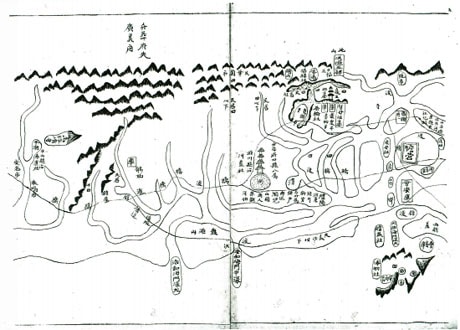
The drawing of Bai Cat Vang in the work "Nam Do in the Year of the Horse".
Following the historical flow from the 17th century to the end of the Nguyen Dynasty, Bai Cat Vang was recorded and described fully and in detail in many sets of documents. These are all original texts, of great value in terms of science, history and law, contributing greatly to affirming the sovereignty of the two archipelagos of Hoang Sa and Truong Sa under the sovereignty of Vietnam. What is special is that in many ancient Vietnamese documents written about Hoang Sa - Truong Sa under the two dynasties of Le and Nguyen, there were up to 7 sets compiled by people from Nghe An, or participated in compiling.
The first book mentioning Bai Cat Vang is the work Thien Nam Tu Chi Lo Do by Giam Sinh Do Ba Cong Dao. He was from Thanh Mai commune, Thanh Chuong district, Nghe An. During the Chinh Hoa years (1680 - 1705), he disguised himself as a merchant and sailed to the South to explore the terrain of mountains and rivers, and to examine the roads and paths of various places. After a thorough survey, he drew a map of the places in Dang Trong and secretly returned to the North to present to the lord.
Lord Trinh was very pleased and continued to let him compile the Four-Way Map. The book consists of 4 volumes, each volume has maps with very specific annotations. Among them is a section about Bai Cat Vang as follows: “... In the middle of the sea, there is an archipelago 400 miles long and 200 miles wide called Bai Cat Vang rising from the seabed towards the coast between the two ports of Dai Chiem and Sa Vinh. During the southwest rainy season, merchant ships from different countries passing near the shore often wrecked in these archipelago areas... Every year during the last month of winter, the Nguyen lords sent to this island a fleet of 18 sailing ships to salvage the sunken ships. They collected a lot of money, guns and ammunition. From Dai Chiem port, it takes a day and a half to reach this archipelago, while it only takes one day if going from Sa Ky...”.
Although only in a short paragraph, the three words Bai Cat Vang are enough to show us clearly that the two archipelagos Hoang Sa and Truong Sa were under the control and management of the Vietnamese, at least since before the years 1680 - 1705. What is special is that these two archipelagos are clearly annotated in Nom script as Bai Cat Vang, clearly showing the folk language of Dang Trong. Later, the Confucian scholars of Dang Ngoai translated them into Sino-Vietnamese as Hoang Sa, Hoang Sa chu...
The second book is the work "Giap Ngo nien binh Nam do" by Doan Quan cong Bui The Dat (1704 - 1778). He was from Dien Ngoc commune, Dien Chau district, Nghe An, and was a famous general under the Le Trinh dynasty. He surveyed and drew this "intelligence" map to present to Lord Trinh in the year of Giap Ngo (1774), to serve the pacification of the South. This map depicts the land of Dang Trong, from Quang Binh to Da Bia mountain in Phu Yen. In which Bai Cat Vang is drawn and annotated offshore Quang Ngai prefecture. It is symbolized by the image of oval-shaped mountains, located between Cu Lao Cham and Cu Lao Re offshore Binh Son district. Thus, this is the second work to appear the term Bai Cat Vang, after Thien Nam tu chi lo do thu by Do Ba Cong Dao.
The third book is Quang Thuan Dao Su Tap by Doctor Nguyen Huy Quynh. Nguyen Huy Quynh (1734 - 1786), nickname Dan Phong, belonged to the 10th generation of the Nguyen Huy family, in Truong Luu, Can Loc district, Ha Tinh. In 1772, he passed the doctoral exam and was appointed as the Inspector General of Son Nam. In 1774, he held the position of Kiem Ly Luong Huong Nhung Vu, in charge of military supplies, participating in the army marching south to pacify Thuan Hoa Phu Xuan. During the years 1778 - 1785, he held the position of Doc Dong and then Doc Thi Thuan Quang and was killed in action right there.
During his time in Dang Trong, he collected historical documents combined with his practical knowledge to compose the Quang Thuan Dao Su Tap, recording the history, geography, and topography of Thuan Hoa - Quang Nam. The book has the following passage: "There are people from An Vang village (Vinh), who produce a lot of peanut oil, weave cloth, and set up a separate Hoang Sa Nhi team. Every year, 8 boats go out to sea to collect valuables and return them to Phu Xuan..." In this book, although there is no map of Bai Cat Vang, it notes the hometown of Cu Lao Re of the Hoang Sa fleet. Combining this record with Le Quy Don's records in Phu Bien Tap Luc, we see that although both are independent works, there is a consistency between the two authors when writing about the history of the Hoang Sa fleet's activities.
The fourth book is Dai Viet Su Ky Tuc Bien, compiled by King Tinh Do Trinh Sam to seven high-ranking mandarins: Nguyen Hoan, Le Quy Don, Vu Mien, Ngo Thi Sy, Pham Nguyen Du, Ninh Ton and Nguyen Sa. Among them, the Governor of Nghe An, Pham Nguyen Du, was the editor of the history book. Pham Nguyen Du was from Nghi Xuan commune, Nghi Loc district, Nghe An. He passed the Huong exam in 1773, and in 1779 he passed the Hoang Giap exam. He also contributed to the Southern pacification of Phu Xuan, so he was promoted to the position of Dong Cac Dai Hoc Si, the first-class rank, and was allowed by the Lord to participate in compiling the history.
In the Dai Viet Su Ky Tuc Bien, there is a section that reads as follows: “Eight people from the Hoang Sa team of An Vinh commune, Binh Son district, Quang Ngai prefecture, went by small boat to Hoang Sa beach in the middle of the island to look for goods, and were blown by the wind to the Thanh Lan river mouth of Van Chuong district, Lo Chau prefecture (belonging to the Qing Dynasty)...”; “In the island there is a Golden Sand Beach about 30 miles long, flat beach with clear water. The island has countless bird nests, and on the sandbank there are also striped snails, commonly called elephant ear snails, abalone shells, fragrant snails, sea worms, sea cucumbers, tortoise shells, etc. The Hoang Sa team consisted of 70 people, and people from An Vinh commune were recruited into the team, taking turns going by boat to the island to look for products...”.
According to our statistics, in addition to the four works mentioned above, there is another very famous work written about Hoang Sa and Truong Sa, which is Phu Bien Tap Luc by Le Quy Don. Thus, under the Le Trung Hung Dynasty, out of more than five works written about Hoang Sa and Truong Sa, four were written by Nghe people. All the authors were born and raised in Dang Ngoai, but they always considered the territory and territorial waters of Dang Trong to be the flesh and blood of the Fatherland and the people. Therefore, they all had the responsibility to protect and record fully and seriously. Through that, it can be seen that the management of Bai Cat Vang under the Nguyen Lords had become a very tight and disciplined system!
Tran Tu Quang (Nghe An Provincial Library)


