Vietnam drones will take pictures of fishing grounds
Drones from the Institute of Space Technology (Vietnam Academy of Science and Technology) will conduct a test flight out to sea with a journey of 100km.
The above information was given by Dr. Pham Ngoc Lang, project manager, after finishing the flight to report to the Central Highlands Steering Committee on May 19.
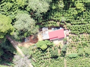
Image obtained from a drone. (Source: Provided by the research team.)
Accordingly, the 3-day flight in the Central Highlands of 6 drones made a total of 37 flights with good results, without any technical errors occurring despite the very complicated flight conditions in Da Lat. The sky in Da Lat was densely cloudy, the air density was very thin, the pressure dropped, the wind was strong, the wind "ascended", "fell", and the amplitude changed erratically.
During the test flight, these aircraft took 10,000 photos and the camera recorded the entire forest area, vegetation, lakes and ground conditions of Lac Duong district, Lam Dong. The working group sent the Central Highlands Steering Committee an aerial photo made from 45 photos with a resolution of 130 megapixels.
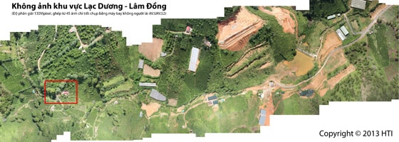
(Source: Provided by the research team.)
According to Mr. Lang, the above 6 aircraft will continue to be tested to serve marine scientific research with the Nha Trang Institute of Oceanography.
No specific time has been given, but the sea flight program is expected to take place in 3 days with a journey of 100km. The planes all carry cameras, specialized cameras, and reflectance spectrometers to measure and take pictures of fishing grounds and the marine ecosystem in the Central region.
“The results of this scientific research test flight will help the research team continue to perfect the aircraft so that they can soon be put into mass production, expected in 2013,” said Mr. Lang./.
According to (Vietnam+) - VT


