NASA launches billion-dollar satellite to forecast weather
The $1.2 billion GOES-R satellite could provide high-resolution imagery and more frequent weather updates, revolutionizing weather forecasting.
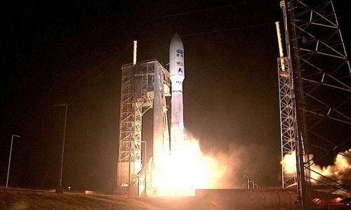 |
| NASA successfully launched the $1.2 billion GOES-R satellite. Photo: NASA. |
NASA has successfully launched the $1.2 billion GOES-R satellite to improve weather forecasting and warnings, increasing the chances of saving lives, Independent reported today. This is part of an $11 billion project to track hurricanes, tornadoes, floods, volcanic ash clouds and wildfires in the US.
The GOES-R satellite will reach its pre-determined equatorial orbit at an altitude of about 35,888 km in two weeks. After completing testing, it will begin operations within the next year.
The satellite, the first to launch since 2010, will be capable of far surpassing previous satellites. It will be able to send images of the entire Western Hemisphere every 15 minutes, instead of the current 30-minute interval. It will also send images of the continental United States every five minutes, with images of specific areas updated every five seconds.
GOES-R is expected to improve weather forecasting and warnings, giving people more time to evacuate before storms.
"If we could have predicted the storm 10 to 20 minutes earlier, more people would have been saved," said NBC meteorologist Al Roker.
Sandra Caufman, associate administrator of NASA's Earth Science Division, said the new satellite was a "quantum leap" and would "really revolutionize weather forecasting".
"The launch of GOES-R is a major step forward in our ability to provide more accurate and timely information that is critical to weather forecasts and warnings, increasing the chances of saving lives," said Thomas Zurbuchen, associate administrator of NASA's Science Mission Directorate.
Information from the satellite will also help pilots avoid areas of bad weather, or help scientists determine the right time to launch missiles. It will also be part of the international Search and Rescue Satellite Tracking System (SARSAT), which can detect distress signals from emergency beacons.
According to VNE


