
Lemon Tree Crossroads
(Baonghean) - On its journey of hundreds of kilometers from the upstream to Cua Hoi before merging into the vast ocean, the Lam River passes through countless junctions and merges with numerous rivers and streams. With each confluence, the river carries a cultural imprint and enriches the land with sacred value. The Cay Chanh junction (in Dinh Son commune, Anh Son district) – where the Con River flows into the Lam River (locally known as the Cai River) – also holds its own unique imprints and values, contributing to the beauty of this prosperous midland region.
I have painstakingly researched the origin of the name "Cay Chanh" (Lemon Tree), a name that now almost completely covers Dinh Son commune (Anh Son district). However, to this day, I have yet to find a reasonable and convincing explanation, even after meeting many elderly people – those who were born, raised, and lived on this land for almost their entire lives. All I know is that the name was initially used to identify the confluence of the Con and Cai rivers, and then people used it to name the entire area.
From the confluence of the Nam Non and Nam Mo rivers at Cua Rao (Tuong Duong), the Lam River receives additional water from the Cha Lap, Huoi Nguyen, Khe Bo, Nam San, Khe Thoi, Khe Choang rivers... And upon reaching Anh Son district, it meets the Con River, from where it begins a new journey. The water no longer flows turbulently through rapids and submerged rocks, but takes on a leisurely, lingering appearance, as if wanting to make a romantic encounter. The Con River, on the other hand, is formed by the confluence of the Nam Giai, Nam Viet, Nam Quang, and Nam Ton rivers in the northwestern districts (Que Phong, Quy Chau, Quy Hop, Nghia Dan), then loops around to Tan Ky, and continues into Anh Son district to merge with the Cai River (the mother river).
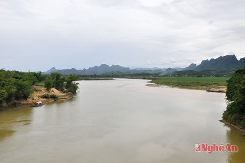 |
| Cay Chanh Junction - the confluence point of the Lam River (main river) and the Con River. |
The Cây Chanh junction is not only the confluence of two streams but also the meeting point of two cultural regions: Southwest and Northwest Nghe An. It is also a point of exchange and convergence of the beautiful cultural features of the lowlands and the highlands. From Cây Chanh upstream to the Southwest and Northwest, there are towering mountain ranges, precarious villages, and folk songs of the Thai, Khmu, Tho, and Mong ethnic groups, imbued with the spirit of the mountains and forests, and the atmosphere of village festivals. Downstream, there are vast alluvial plains and fields, perpetually green with rice, corn, beans, peanuts, mulberry, and sugarcane. These prosperous, verdant villages are the source of simple yet captivating folk songs and melodies, full of affection and profound meaning. Names like Bai Mo, Bai Hoi, Bai Lang Trang, Dong Dua, and Ben Hat evoke the fertility of the land and the poetic beauty of the landscape. And it is also in this place that many people who have dedicated their lives to the folk songs and melodies of Nghe An province have been born, such as composers Thanh Luu and Van The, and Meritorious Artist Tien Dung.
Geographically, the Cay Chanh intersection serves as a connecting point between districts along National Highway 7A and National Highway 48, between National Highway 7A and 7B, and between the lowlands and highlands. From here, one can travel north to Con Cuong, Tuong Duong, and Ky Son; turn towards Tan Ky, Nghia Dan, and Quy Hop; and south to Do Luong, Yen Thanh, and Dien Chau. Therefore, the Cay Chanh area has many advantages for expanding exchanges, promoting trade, and accelerating socio-economic development. In particular, with the completion of the bridge across the Lam River a few years ago, and the bridge across the Con River also finished, the Cay Chanh area in general, and the Cay Chanh intersection in particular, has taken on a new look. The Song Lam sugar factory has also been relocated to the river confluence, helping farmers develop their production strengths and providing them with more opportunities to improve their lives thanks to sugarcane.
For a long time, Cay Chanh - Dinh Son has been known to people near and far as a dynamic rural area in its socio-economic development, with Cay Chanh market serving as a major trading hub for the entire region. This is understandable, given that the people know how to capitalize on the advantages of their local space and geographical location. The Cay Chanh town center is becoming increasingly bustling with its market, modern high-rise buildings, and upgraded roads. All of this is contributing to the emergence of a modern urban area at the confluence of three rivers, an urban center with rivers, mountains, and lush green fields, which will surely become even more vibrant.
Cong Kien