Nghe An issues telegram to proactively respond to storm No. 7
(Baonghean.vn) - On the morning of October 30, storm NALGAE entered the East Sea and became storm number 7. The strongest wind near the storm's center was level 10, gusting to level 12. The storm's development is forecast to be complex and unpredictable due to interaction with cold air. Therefore, Nghe An has issued a telegram to proactively respond to the storm.
The content of Dispatch No. 15/CD-BCH clearly states: According to the bulletin of the National Center for Hydro-Meteorological Forecasting, on the morning of October 30,Storm NALGAEentered the East Sea and became storm number 7. At 7:00 a.m. on October 30, the center of the storm was at about 16.2 degrees North latitude; 119.0 degrees East longitude, in the southeast sea area of the North East Sea.
It is forecasted that in the next 24 hours, the storm will move in the West Northwest direction, traveling 15km per hour and is likely to strengthen to level 10-11, gusting to level 13 when approaching the Hoang Sa archipelago. After that, the storm will interact with cold air and be influenced by two subtropical high pressure air masses, so it will change direction and develop unpredictably.
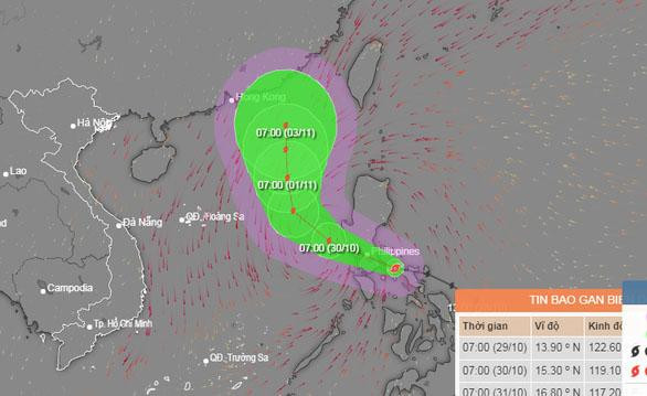 |
Location and direction of storm No. 7. Photo: NCHMF |
Due to the impact of the storm, the eastern sea of the North and central East Sea has strong winds of level 7-8, then increasing to level 8-9, near the eye of the storm strong winds of level 10-11, gusts of level 13, waves 5-7m high, near the eye of the storm 7-9m, rough seas.
The western sea area of the North and Central East Sea (including the sea area of Hoang Sa archipelago) has strong Northeast to North winds at level 6-7, rough seas.
Level 3 natural disaster risk in the eastern region of the North and Central East Sea.
To proactively respond to storms and minimize damage, localities and relevant agencies need to direct and immediately implement necessary measures according to assigned tasks.
Accordingly, closely monitor the storm's developments to inform owners of vehicles and captains of ships and boats (including transport ships) operating at sea of the location, direction of movement and developments of the storm so that they can proactively avoid, escape or not move into dangerous areas.
The dangerous area in the East Sea in the next 24 hours is determined from latitude 13.5 - 18.5 degrees North; east of longitude 114.5 degrees East (dangerous area is adjusted in forecast bulletins).
At the same time, organize monitoring and counting of ships and boats operating in the storm-affected area; strictly manage vessels going out to sea; maintain regular communication with vessel owners to promptly handle bad situations that may occur.
Ready rescue forces and vehicles to promptly handle situations.
The North Central Region Hydrometeorological Station closely monitors, forecasts, warns, and promptly informs about storm developments to proactively deploy response measures; Departments and branches, according to their assigned functions and tasks, direct measures to be ready to respond when bad situations occur.
Units: Provincial Radio and Television Station, Nghe An Newspaper and mass media agencies increase information and communication about storm developments and response direction.


