Nghe An: After storms, many river banks have serious landslides
(Baonghean.vn) - After prolonged heavy rains due to the influence of storm No. 6, many river banks in Nghe An province suffered serious landslides, sweeping away farmland into the river, threatening many houses along the riverbank.
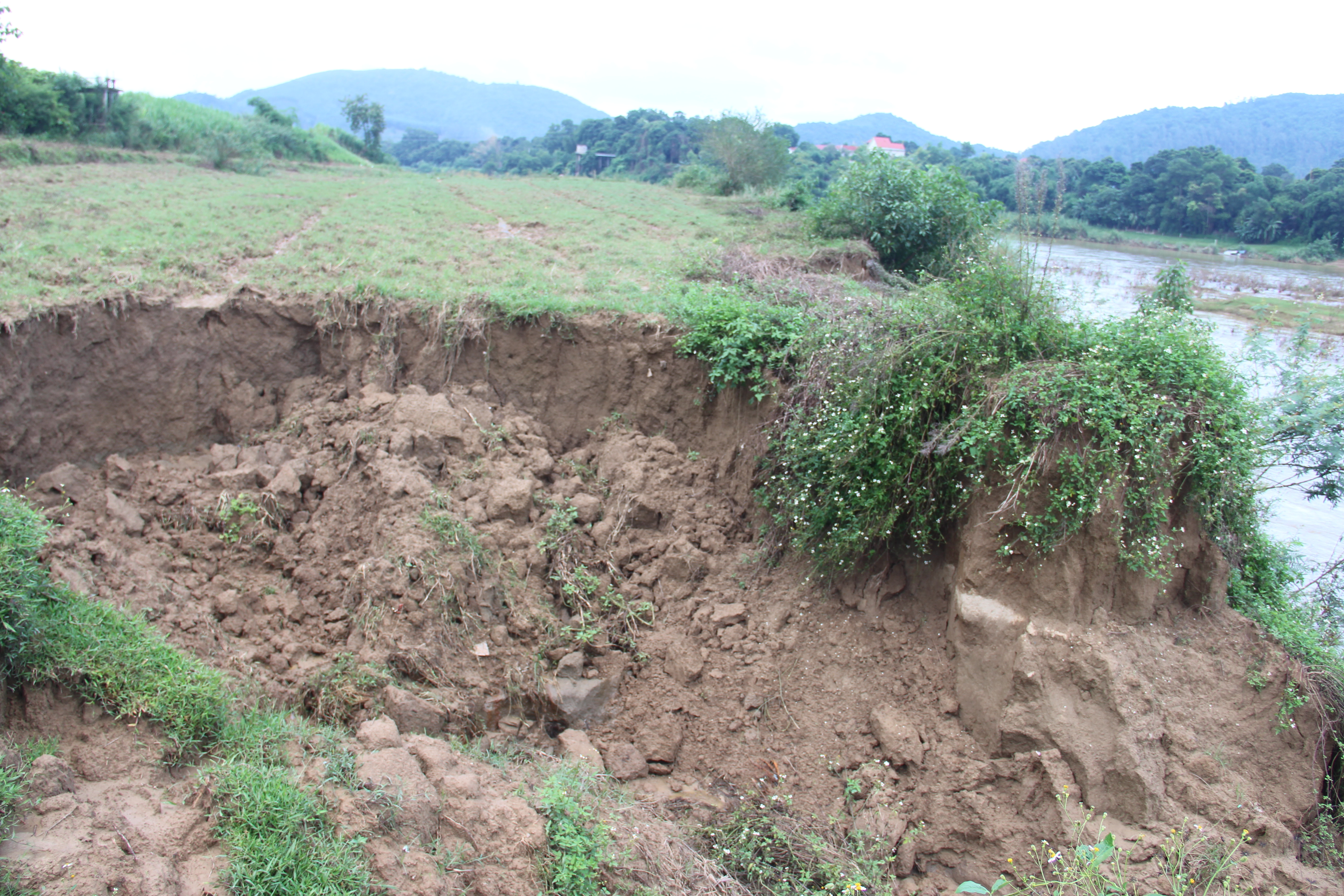 |
| The bank of Hieu River passing through Tay Ho 1 block, Quang Tien ward (Thai Hoa town) has collapsed, eating into cultivated land more than 20 meters. Photo: Van Truong |
Along the Hieu River bank, over 1 km long, passing through the Tay Ho 1 block, Quang Tien ward (Thai Hoa town), landslides are occurring seriously. The riverbank is cracked and eroded, even into cultivated land. Ms. Nguyen Thi Quynh, who lives in Tay Ho 1 block, Quang Tien ward (Thai Hoa town), worriedly said: The alluvial land of the Hieu River bank used to be more than 100 meters wide, but every time there is a flood, the Hieu River bank erodes further into the bank, now the landslide has reached the people's fields, only about 20 meters away from the residential area.
According to the investigation, this landslide is close to Hieu bridge, so hundreds of households in Tay Ho block 1 are worried day and night when the flood is getting closer to the residential area. Some local residents reported that before 2017, the sand mining situation caused the Hieu riverbank to change its flow, causing landslides.
 |
| This landslide is close to Hieu bridge, behind are hundreds of households of Tay Ho block 1. Photo: Van Truong |
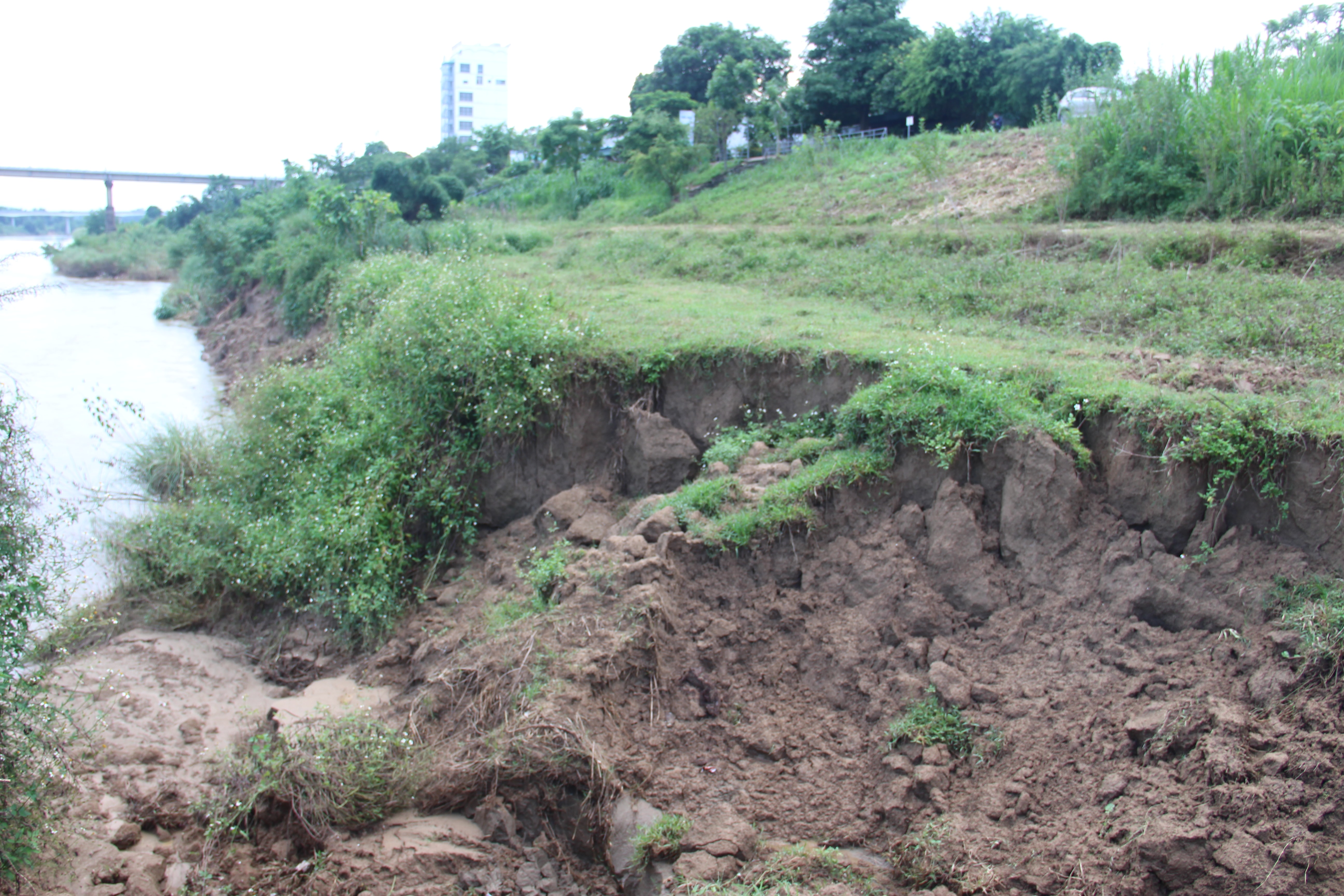
Also in the above situation, currently in Anh Son district, there are many landslides on Lam river banks. For example, in Tam Son commune, every time the rainy season comes, people living along the river are constantly worried about landslides because the Lam river flows rapidly, swirls into the banks, and carries away a lot of land and trees.
Mr. Phan Van Phuc in Hamlet 1, Tam Son Commune added: Landslides in this area have been happening for nearly 5 years, after each flood the land is encroached 8-10 meters deep. At that time, the alluvial land was still located along the river, but now a lot of residential land has been swept away into the river, making us feel insecure. If this continues for the next few years, there is a risk that the river will sweep away our entire house.
 |
| Landslide on Lam River bank through Tam Son commune, Anh Son district. Photo: Contributor |
Mr. Nguyen Van Que - Chairman of Tam Son Commune People's Committee said: The Lam River bank through Tam Son Commune is being eroded heavily, concentrated in Hamlet 1 with a length of about 1.5 km, over 20 households have had their residential land encroached by the river, and over 100 other households are in a state of threat.
Before the rainy season, the commune mobilized people to plant bamboo stakes to prevent landslides, but after the recent floods, they were all swept away into the river. During the rainy season, the commune notified people living along the river and checked households in dangerous areas to have a plan for evacuation.
Mr. Hoang Quyen - Chairman of Anh Son District People's Committee added: Anh Son district has over 40 km of Lam River passing through. In particular, there are currently 2 communes of Tam Son and Cam Son with over 200 households at risk of being threatened by riverbank erosion, in which, in Cam Son commune, there are outbuildings of households that have been swept into Lam River due to erosion.
The communes are submitting to the Anh Son District People's Committee solutions to overcome the riverbank erosion. However, the current difficulty is limited capital, so it is not possible to invest in building anti-erosion embankments. The solution is that during the rainy and stormy season, the district directs the communes to monitor the weather and evacuate people when necessary.
 |
| Landslide on the Bung River bank through Dien Hoa commune (Dien Chau) caused the riverbank to be deformed. Photo: Van Truong |
In Dien Chau, the dike of the Bung River estuary passing through Dien Hoa Commune also experienced many landslides, some of which were completely broken off. Following the Bung River, we witnessed the entire dike section passing through Hamlet 2, Dien Hoa Commune, collapsing, cracking, and soil being pulled down into the river, causing the dike to deform.
According to the report of Dien Hoa Commune People's Committee (Dien Chau), the Bung River flows through the commune for 7 km. During the flood from September 23-25, the Bung River dike was eroded at 5 points with a length of nearly 70 meters. According to the plan, after the water recedes, the commune will temporarily fix the problem by driving bamboo stakes and filling the soil...
 |
| The Con River bank through Nghia Dong commune (Tan Ky) was eroded. Photo: Contributor |
After prolonged heavy rains due to the influence of storm No. 6, Nghe An province has many riverbanks eroded, mainly concentrated in the districts of Anh Son, Do Luong, Tan Ky, Nghia Dan, Thanh Chuong...
Riverbank erosion is becoming serious during the rainy and stormy season. The effective solution is to build stone embankments to prevent erosion. However, due to large capital resources, many districts can only build embankments in key sections. Many places cannot build embankments yet, and can only be solved with temporary solutions./.

Nghe An focuses on overcoming landslides
(Baonghean.vn) - Heavy rains caused by storm No. 6 in recent days have caused landslides on many roads in mountainous districts of Nghe An. The Department of Transport is directing units to focus on overcoming the landslides.

Close-up of Nguoc Mountain continuing to suffer severe landslides
(Baonghean.vn) - After being repaired, last night (September 24), Nguoc mountain in Thanh Chuong district continued to have a strong landslide, threatening traffic safety on National Highway 46.

.jpeg "Nhiều điểm sạt lở núi trên Quốc lộ 7C gây mất an toàn giao thông")

.jpg "Phát hiện vết nứt dài cả trăm mét trên sườn núi, xã vùng cao Nghệ An cử người canh gác để di dời dân")


