Constant worry along the banks of the Hieu and Dinh rivers.
(Baonghean) - The Hieu River section passing through Chau Tien commune (Quy Chau district) and the Dinh River through Tam Hop commune (Quy Hop district) have recently become more turbulent during the rainy season and floods, encroaching deeply into cultivated land and residential areas on both banks, greatly affecting the production and daily lives of the people...
We visited Minh Tien village, Chau Tien commune (Quy Chau district), along the banks of the Hieu River, and witnessed the ongoing erosion. In some places, the river was encroaching right up to people's houses, with some areas experiencing landslides 10-12 meters deep... Mr. Dang Ngoc Phan (55 years old) from Minh Tien village led us to the back of his house and said: "The riverbank is only about 6-7 meters from my house. My family invested in buying gabions to prevent erosion, but then the floodwaters swept them all away." Right next to it was Ms. Nga's house, precariously perched on the edge of the landslide; she said: "A few years ago, the landslide swept my family's house into the river. I moved further inland and built another house, but now I'm in danger of losing that too."
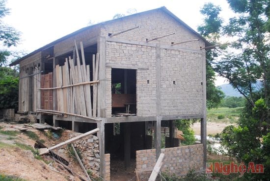 |
| Houses built on concrete piles continue to spring up right along the banks of the Hieu River. |
During the annual rainy season, the Hieu River rises, its waters churning up like muddy red, sweeping away many bamboo groves and large trees along the riverbank. Some families have to seek refuge elsewhere, but others risk staying put. It is known that the erosion along the Hieu River bank passing through Minh Tien village is approximately 1 km long, with the lowest point of erosion being 4-5 meters and the highest over 10 meters. In the last 5 years, Minh Tien village has lost nearly 1 hectare of residential land to the river. Currently, the riverbank has encroached right up to the houses of the residents, threatening their lives during the rainy season. When asked why they haven't moved to a safer place, some residents said they haven't wanted to leave because they have lived there for decades, along National Highway 48, near the Hang Bua tourist spot, making it easy to do business.
Mr. Nguyen Thanh Hoai, Head of the Finance Department of Quy Chau District, added: “In Minh Tien village, over 40 households living along the Hieu River are in a dangerous situation due to riverbank erosion. For many years, the District People's Committee has not issued land ownership certificates ("red books") to these households; at the same time, the district and commune have been campaigning and strictly prohibiting people from building or expanding their houses... The current solution is to plan and resettle over 40 households to a safe place. However, the difficulty is that the commune has limited land resources and lacks the funds to build infrastructure for resettlement.”
The Dinh River, in the Tam Hop commune (Quy Hop district), specifically in the hamlets of Quyet Tien, Tan My, Tan Mung, Dinh, and Dong Chao, is also severely eroded. Ms. Ho Thi Hai's house in Tan Mung hamlet is less than 10 meters from the riverbank; she expressed her concern: “My garden land used to be very large, but in recent years the river has been eroding it very quickly, now it's almost right next to my house. I hope the government will find a solution to reinforce the riverbank so we can have a stable life.”
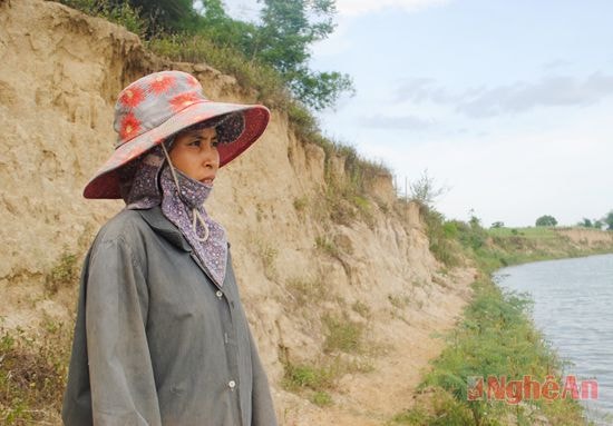 |
| Ms. Ho Thi Hai from Tan Mung village (Tam Hop, Quy Hop) at the landslide site along the Dinh River. |
In Tan Mung hamlet alone, over 130 households (mostly of the Tho ethnic group) are facing the highest risk of landslides. The hamlet has lost over 20 hectares of cultivated land and 10 hectares of residential land due to landslides, with over 30 households under relocation warning. Mr. Hoang Xuan Ngu, Chairman of the Tam Hop Commune People's Committee, stated: Landslides have occurred along the Dinh River for over 3 km, affecting approximately 150 households in the entire commune. Of these, over 50 households are located in particularly dangerous areas requiring relocation, including the villages of Quyet Tien, Tan My, Tan Mung, Dinh hamlet, Dong Chao, etc.
From 2011 to the present, the commune has only managed to relocate nearly 10 households to safe areas, while most households remain clinging to the riverbanks because life is too difficult and they lack the money to buy land. Besides the damage to people's land and property, the Dinh River has wiped out the old Highway 532, which was over 2 km long. The newly built commune People's Committee headquarters is also only about 50 meters from the Dinh River bank. To cope with the erosion, in recent years the commune People's Committee has mobilized the people to plant bamboo and drive bamboo stakes in some severely eroded areas, but it has been ineffective; every flood season everything is swept away into the river. "From 2013 to the present, provincial and district officials have surveyed the area many times and planned to reinforce the Dinh River banks, however, nothing has materialized yet," Mr. Ngu said.
According to frustrated residents, the reason rivers become so ferocious during the rainy season, gradually eroding riverbanks, is due to rampant and indiscriminate deforestation and mining upstream and along the riverbeds... But that's a fait accompli... The problem is that another rainy season is approaching, and officials and people in the aforementioned localities are overwhelmed with worry about landslides.
Van Truong

