The shocking disappearance of the world's fourth largest lake
The US National Aeronautics and Space Administration (NASA) has just announced evidence that the world's fourth largest lake, located in the middle of the Kyzylkum desert in Central Asia, has disappeared.
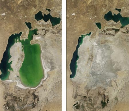 |
| This photo shows the dramatic changes in the Aral Sea from August 2001 (left) to September 2014 (right). Photo: NASA |
A series of images taken by NASA's Terra satellite has revealed the astonishing changes to the Aral Sea from 2000 to 2014. Once the world's fourth largest lake, a massive water diversion project initiated by the Soviet Union in the 1960s has caused the Aral Sea to shrink significantly, and this year it has completely dried up for the first time.
According to NASA, in the 1960s, the Soviet Union undertook a major water diversion project across the parched plains of Kazakhstan, Uzbekistan, and Turkmenistan. The region’s two major rivers, enriched by snowmelt and deposits in remote mountains, were used to turn the desert into farms for cotton and other crops.
Before the project, the Syr Darya and Amu Darya rivers flowed from the mountains, snaked northwest, through the Kyzylkum Desert, and eventually converged in the lowest part of the basin, forming the Aral Sea.
While the irrigation project helped the desert grow greener, it also damaged the Aral Sea. NASA satellite images have documented these changes. In 2000, the sea was still a small fraction of its massive size in 1960 (black line). The North Aral Sea (sometimes called the Little Aral Sea) had split from the South Aral Sea (the Great Aral Sea). And the South Aral Sea had split into two branches, an eastern and a western, barely connected at both ends.
By 2001, the southern connection had been severed, and the shallower eastern section retreated rapidly over the following years. In particular, major retreats in the eastern arm of the South Aral Sea appear to have occurred between 2005 and 2009, when drought limited and then cut off the flow of the Amu Darya.
The lake’s water levels then fluctuated annually, alternating between wet and dry seasons from 2009 to 2014. The 2014 drought caused the eastern arm of the South Aral Sea to dry up completely for the first time in modern times. As the lake dried up, so did the fisheries and communities that depended on them.
The increasingly salty waters are polluted by fertilizers and pesticides. Dust blown up from the dried-up lake bed, contaminated with agricultural chemicals, has become a public health hazard.
The loss of the water’s moderating influence also leads to more extreme temperatures in the region, making winters colder and summers hotter and drier. Salt dust blown off the lake floor and covering the fields erodes the soil, according to NASA. The soil also requires more and more watering.
In a last-ditch effort to save part of the lake, Kazakhstan built a dam between the northern and southern Aral Seas. Completed in 2005, the dam essentially spells death for the South Aral Sea, which was considered beyond saving. All the water that flows into the desert basin from the Syr Darya River now flows into the North Aral Sea.
From 2005 to 2006, the water level in that part of the lake rose significantly again and has increased by a very small, but noticeable amount since then.
Differences in water color are due to sediment changes.
According to Vietnamnet


