Thanh Hoa, Nghe An have heavy rain, beware of tornadoes in thunderstorms
(Baonghean.vn) - Warning, from July 27, heavy rain tends to spread to the entire North and North Central regions and is likely to last until early August.
According to the National Center for Hydro-Meteorological Forecasting, as of 1:00 a.m. on July 26,dDue to the influence of the tropical convergence zone, in the North and Thanh Hoa, there has been rain, moderate rain, heavy rain in some places with common rainfall of 20-40mm, in some places over 50mm such as Sin Ho (Lai Chau) 54mm, Van Yen (Son La) 59mm, Yen Chau (Hoa Binh) 54mm, Bao Ha (Lao Cai) and Ha Nam 87mm,...
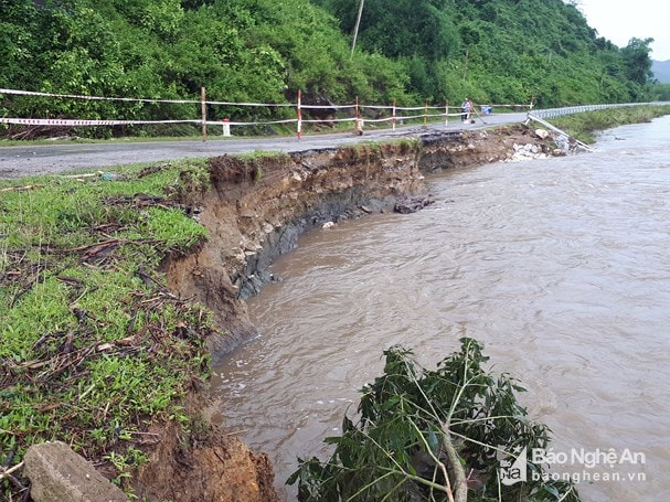 |
| National Highway 48D at km 112 + 400, through Muong Ham village, Chau Cuong commune, Quy Hop district (Nghe An) was damaged by nearly 50m of road and railings due to floods from Muong river during storm No. 3. Photo: Ho Phuong |
Currently (July 26): The tropical convergence zone has an axis passing through the Northern region. It is forecasted that due to the influence of the tropical convergence zone, today and tonight (July 26) in the Northern region and the provinces of Thanh Hoa and Nghe An, there will be rain, some places will have moderate rain, heavy rain and scattered thunderstorms; especially in the Northwest region (Lai Chau, Dien Bien, Son La, Hoa Binh) and Viet Bac (Lao Cai, Yen Bai, Phu Tho, Tuyen Quang) there will be heavy to very heavy rain (50-120mm/24 hours). There is a possibility of tornadoes and strong gusts of wind during the storm.
Level of natural disaster risk due to heavy rain: level 1; in the provinces of Lai Chau, Dien Bien, Son La, Hoa Binh, Lao Cai, Yen Bai, Phu Tho: level 2.
Warning: From July 27, heavy rain tends to spread to the entire North and North Central regions and is likely to last until early August.
Besides, due to the influence of the tropical convergence zone combined with the strong southwest monsoon, during the day and tonight, in the South East Sea area (including the sea area of Truong Sa archipelago) and the sea area from Binh Thuan to Ca Mau, there will continue to be strong southwest winds at level 5, sometimes level 6, gusting to level 8, waves 2-3m high; rough seas.Disaster risk level: level 1.
FLASH FLOOD, LANDSLIDE WARNING
TUYEN QUANG, THAI NGUYEN:
Through monitoring rain products, currently in Tuyen Quang and Thai Nguyen provinces there is heavy rain, rainfall in the past 3 hours (from 03-05/26/07) at Lang Quan station: 41mm, Kien Thiet: 15.6mm (Yen Son district, Tuyen Quang), Thai Hoa: 40.8mm (Ham Yen district, Tuyen Quang); Phu Dinh station: 20.4mm (Dinh Hoa district, Thai Nguyen)
Comments:In the next 1-3 hours, this area will continue to have heavy rain with total rainfall likely to reach 30-50mm.
Warning: In the next 3-6 hours, flash floods and landslides are at risk in Tuyen Quang and Thai Nguyen provinces, with a particularly high risk in the districts of Yen Son, Ham Yen (Tuyen Quang), and Dinh Hoa (Thai Nguyen). Disaster risk warning level: level 1.
LAI CHAU, DIEN BIEN:
Through monitoring rain products, in Lai Chau province, Dien Bien has heavy rain, rainfall in the past 2 hours (from 22:00/25/07-0:00/26/07) at Nam Cuoi station: 46mm, Nam Tam: 39mm, Can Co: 20mm (Lai Chau province), Ta Phin 42mm (Dien Bien province).
Comments:In the next 1-3 hours, this area will continue to have rain, with total rainfall reaching 10-20 mm, in some places over 40 mm.
Warning: In the next 3-6 hours, there is a risk of flash floods and landslides occurring in Lai Chau and Dien Bien provinces, especially in Sin Ho (Lai Chau) and Tua Chua (Dien Bien) districts. Disaster risk warning level: level 2


.jpg "Gia cố ao hồ nuôi trồng thuỷ sản phòng ngập do mưa to")
 đến hết ngày 26/8, dự báo Nghệ An có mưa to đến rất to, với lượng mưa phổ biến 200-400mm, cục bộ có nơi trên 600mm")

-0c4b6727bd7cc728c4884fd2ba48c9e9.jpg "Thời tiết Nghệ An ngày 18/8: Ngày nắng yếu, chiều và đêm có mưa to và dông")