News on TROPICAL LOW PRESSURE ON LAND (weakened from storm No. 5): Nghe An has heavy rain from early morning of August 26 to the end of August 26
According to the news released at 5am on August 26 by the National Center for Hydro-Meteorological Forecasting, early this morning, storm No. 5 weakened into a tropical depression in the Central Laos region.
Current status of tropical depression
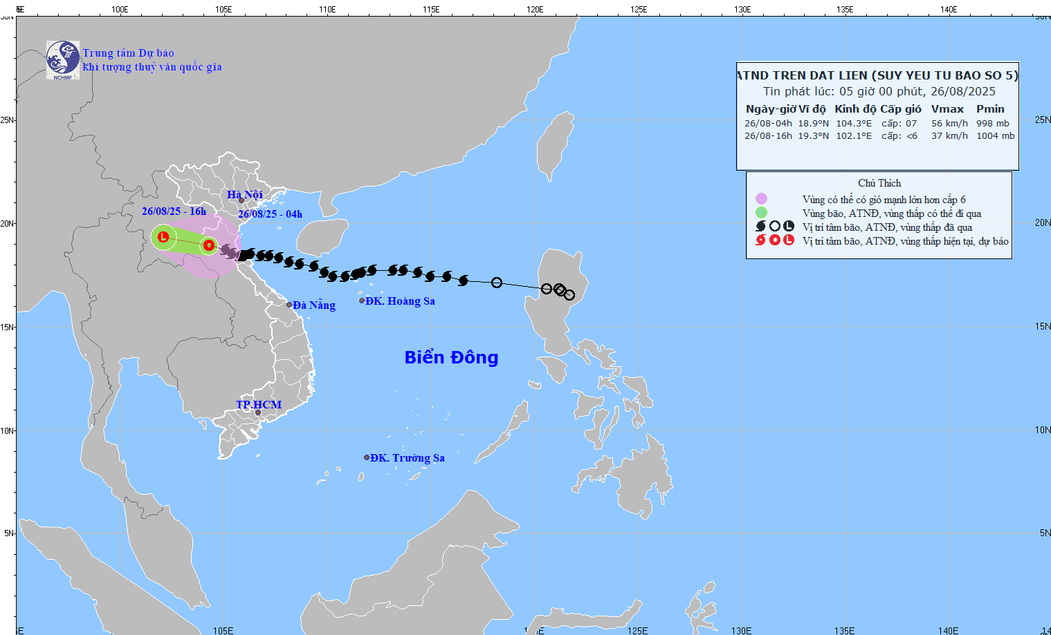
04:00 August 26: Center at18.9°N - 104.5°E (Central Laos).
Strongest windlevel 7 (50–61km/h), level 9 jerks; moveWest Northwest 15–20km/h.
Previously, many coastal stations in Nghe An - Ha Tinh recorded strong winds.level 8–10, jerk 12–15; water level rose at Hon Ngu 1.66m, Sam Son 1.01m.
In the Northern Delta provinces, from Thanh Hoa to Quang Tri, there has been moderate to heavy rain, and in some places very heavy rain over 600mm.
Forecast:
4:00 p.m. August 26:Location 19.3°N – 102.1°E (Central Laos),weaken into a low pressure area < level 6.
Danger zone: 17.0 - 20.5°N; West 108.5°E.
Risk: Level 3 (Gulf of Tonkin).
Impact forecast:
At sea:This morning (August 26), in the Gulf of Tonkin (Bach Long Vi, Cat Hai, Co To, Van Don, Hon Ngu): windlevel 6-7, jerk 8, waves 2-5m, rough sea.
On land:Thanh Hoa - Nghe An, Ninh Binh coast: windlevel 6-7, jerk 9.
Heavy rain:From early morning of August 26 to the end of August 26: Northern Midlands & Delta, Lao Cai, Son La, Thanh Hoa - Ha Tinh:50-100mm, some places >200mm, risk of heavy rain intensity >100mm/3h.
Hanoi: heavy rain with thunderstorms; Da Nang: no rain; Ho Chi Minh City: showers and thunderstorms in the evening.
From early morning of August 26-27: Upper & Central Laos:100–250mm, locally >500mm.
.jpeg "Kịp thời cứu người đàn ông mắc kẹt trong căn nhà bị tốc mái giữa bão số 5")


