URGENT STORM NEWS (Storm No. 13) has entered the eastern sea area of the central East Sea.
Early this morning (November 5), storm Kalmaegi entered the eastern sea area of the central East Sea, the 13th storm in the East Sea in 2025.
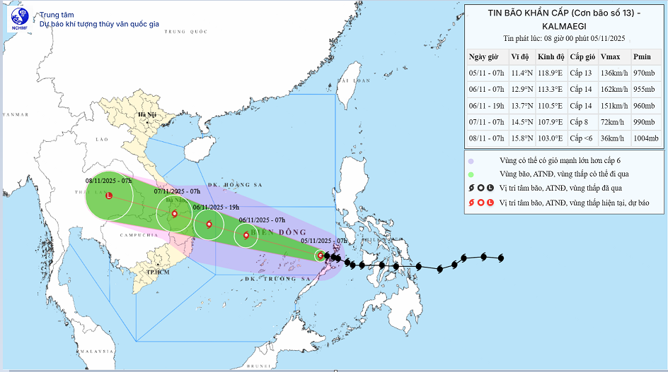
At 7:00 a.m., the center of the storm was at about 11.4 degrees North latitude; 118.9 degrees East longitude, about 500km east of Song Tu Tay island. The strongest wind near the center of the storm was level 13 (134-149 km/h), gusting to level 16. Moving in the West Northwest direction at a speed of about 20km/h.
Forecast of storm impact:
On the sea:
- The central East Sea area (including the sea area north of Truong Sa special zone) has strong winds of level 8-11; the area near the storm's eye has strong winds of level 12-14, gusts of level 17, waves 5.0-7.0m high, the area near the storm's eye has waves of 8.0-10.0m high; the sea is very rough.
- From early morning of November 6, the sea area from Da Nang City to Khanh Hoa (including Ly Son special zone) will have strong winds of level 6-7, then increase to level 8-11, the area near the storm center will have strong winds of level 12-14, gusting to level 17; the coastal area from Hue City to Dak Lak will have waves 4.0-6.0m high, the area near the storm center will have waves 6.0-8.0m high; the sea will be very rough.
Storm surge and coastal flood warnings:
Coastal areas from Hue City to Dak Lak have storm surges of 0.3-0.6m high.
Warning:From the evening of November 6, coastal areas from Hue City to Dak Lak are on guard against rising sea levels accompanied by large waves causing flooding in low-lying areas, waves overflowing dikes, coastal roads, coastal erosion, slowing down flood drainage in the area. All ships, boats, and aquaculture areas in the above-mentioned dangerous areas are strongly affected by storms, whirlwinds, strong winds, large waves, and rising sea levels.
On land:
- From the evening of November 6, on the mainland along the coast from South Quang Tri to Da Nang City, the eastern part of the provinces from Quang Ngai to Dak Lak, the wind will gradually increase to level 6-7, then increase to level 8-9, the area near the storm's center will be strong at level 10-12 (focusing on the eastern part of Quang Ngai-Dak Lak provinces), gusting to level 14-15.
- From the evening and night of November 6, in the West of the provinces from Quang Ngai to Dak Lak, the wind will gradually increase to level 6-7, near the storm's eye, it will be level 8, gusting to level 10.
Heavy rain:
- From November 6-7, the area from Da Nang City to Dak Lak will have very heavy rain with common rainfall of 200-400mm/period, locally over 600mm/period; the area from South Quang Tri to Hue City, Khanh Hoa and Lam Dong will have heavy rain with common rainfall of 150-300mm/period, locally over 450mm/period. From November 8, heavy rain in the above areas will tend to decrease.
- From November 7-8, the area from North Quang Tri to Thanh Hoa will have moderate to heavy rain with common rainfall of 50-150mm/period, locally very heavy rain over 200mm/period.
Warning of risk of heavy rain (>200mm/3h).
Thunderstorms, tornadoes:
Due to the influence of the wide storm circulation, it is necessary to guard against the risk of thunderstorms, tornadoes and strong gusts of wind both before and during the storm's landfall.


