Storm news number 3 storm WIPHA, when will the storm move to Ha Long Bay?
Update information on the development of storm number 3 - storm WIPHA. At about 19:00 on July 21, the storm will enter the northern sea area of the Gulf of Tonkin including Co To, Ha Long Bay, Cat Ba
Forecast of storm No. 3 - storm WIPHA (in the next 24 to 72 hours):
Current status (at 4:00 p.m. on July 19): At 7:00 p.m., the center of storm No. 3, storm WIPHA, was at about 21.1 degrees North latitude; 117.7 degrees East longitude, in the northeastern sea area of the North East Sea.
The strongest wind near the storm center is level 10-11 (89-117km/h), gusting to level 14; moving in the West Northwest direction at a speed of about 20-25km/h.
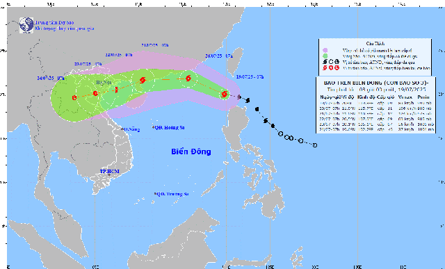
| Forecast time | Direction, speed | Location | Intensity | Danger zone | Disaster Risk Level (Affected Area) |
| 7:00 p.m., July 20 | West Northwest, then West 20-25km/h and likely to strengthen | 21.5N-112.2E; in the northwest sea of the North East Sea; about 220 km east of Leizhou Peninsula (China) | Level 11-12, level 15 jerk | Latitude 19.0N-23.0N; longitude 110.5E-120.0E | Level 3: Northern sea area of the North East Sea |
| 7:00 p.m., July 21 | West Southwest, about 15km/h | 20.9N-108.5E; in the northern sea of Tonkin Gulf | Level 10-11, level 13 jerk | North of latitude 19.5N; West of longitude 114.0E | Level 3: Northwest sea area of the North East Sea, Gulf of Tonkin |
| 7:00 p.m., July 22 | West Southwest, 10-15km/h and weakening | 20.3N-105.7E; on the mainland of the Northern Delta and Thanh Hoa | Level 8, level 10 | North of latitude 19.0N; West of longitude 110.5E | Level 3: Gulf of Tonkin waters |
Warning of storm No. 3 - storm WIPHA (from next 72 to 96 hours)
From the next 72 to 96 hours, the storm will move mainly in the West Southwest direction, traveling 5-10km per hour and continue to weaken.
From July 21, the northern Gulf of Tonkin (including the special zones of Bach Long Vi, Co To, Cat Hai, Cat Ba) will have winds gradually increasing to level 6-7, then increasing to level 8-9, the area near the storm's center will have winds of level 10-11, gusting to level 14; waves 2.0-4.0m high, the area near the center will be 3.0-5.0m. The sea will be very rough.
From the afternoon of July 21, the sea in the southern Gulf of Tonkin will have winds gradually increasing to level 6-7, near the storm center level 8-9, gusting to level 11, waves 2.0-4.0m high. The sea will be very rough.
Vessels operating in the above mentioned dangerous areas are susceptible to the impact of storms, whirlwinds, strong winds and large waves.
Heavy rain warning, level 1 natural disaster
From the afternoon of July 21 to July 23: The North and North Central regions will experience widespread heavy rain. Rainfall will be generally 100-200mm, locally over 300mm.
The Northeast region, the Northern Delta, Thanh Hoa, and Nghe An have heavy to very heavy rain: 200-350mm, in some places over 600mm.
Risk: Local heavy rain with intensity >150mm/3 hours at some locations
High risk: Flash floods on small rivers and streams; landslides on steep slopes; flooding in low-lying areas, urban areas, and industrial zones
Warning: Beware of tornadoes, lightning, hail and strong winds during thunderstorms.
People in mountainous areas, along rivers and steep slopes need to closely monitor warnings, especially from the flash flood and landslide warning system at: 👉https://luquetsatlo.nchmf.gov.vn
Natural disaster risk level: Level 1 (due to heavy rain, tornado, lightning, hail)


