Nghe An issues a dispatch to respond to storms and the risk of heavy rain, floods, inundation, flash floods, and landslides due to the impact of storm No. 3 WIPHA
At 3:30 p.m. on July 19, the Steering Committee for Natural Disaster Prevention, Search and Rescue and Civil Defense of Nghe An province issued Official Dispatch No. 05, directing proactive response to storms and risks of heavy rain, floods, inundation, flash floods, and landslides.
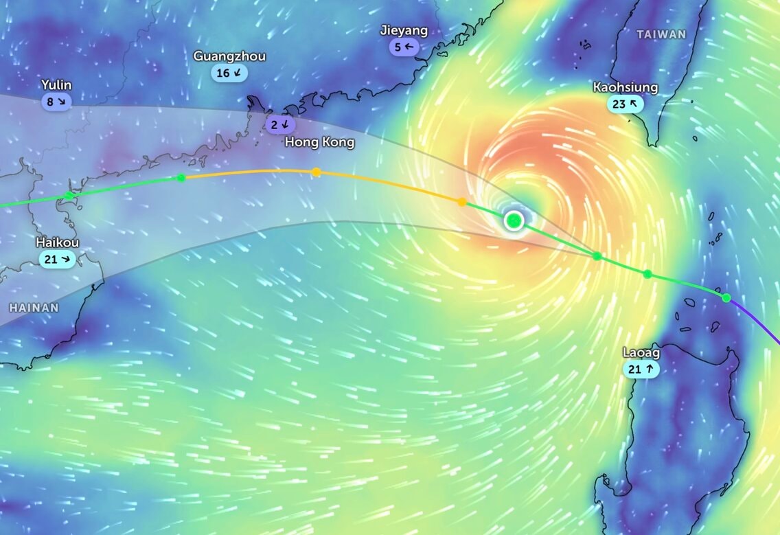
The dispatch stated: On the morning of July 19, storm WIPHA entered the East Sea and became storm number 3 with a level 9 intensity, gusting to level 12; the storm is forecast to continue to strengthen and potentially affect and cause heavy rain in the Northern and North Central regions in the coming days.
According to the bulletin from the Nghe An Province Hydrometeorological Station, at 1 p.m., the center of the storm was at about 20.5 degrees North latitude; 119.0 degrees East longitude, in the northeastern sea area of the North East Sea. The strongest wind near the center of the storm was level 9-10 (75-102 km/h), gusting to level 12; moving northwest at a speed of about 20 km/h.
Pursuant to Official Dispatch No. 4594 dated July 19, 2025 of the Ministry of Agriculture and Environment on responding to storms in the East Sea, to proactively respond to storms and the risk of heavy rain, floods, inundation, flash floods, landslides, the Provincial Steering Committee for Natural Disaster Prevention, Search and Rescue and Civil Defense requests the Steering Committees for Natural Disaster Prevention, Search and Rescue and Civil Defense of wards, communes and related departments and branches to direct the implementation of the following contents:
For sea routes:
Closely monitor the storm's developments; strictly manage vessels at sea; organize counting and notify owners of vessels and captains of ships and boats operating at sea of the location, direction of movement and developments of the storm to proactively avoid, escape, not move into dangerous areas or return to safe shelters. Dangerous areas in the next 24 hours: Latitude 18.5N - 23.0N; East of longitude 112.0E (dangerous areas are adjusted in forecast bulletins).
Implement work to ensure safety of people, vehicles, and property, especially at tourist sites, aquaculture, fishing, and constructions at sea, on islands, and in coastal areas.
Based on the specific situation, proactively decide to evacuate people in cages, aquaculture huts along the coast, at sea, and on islands to ensure safety.
The Provincial Military Command directed the Provincial Border Guard Command to base on storm developments and forecasts to promptly advise the Provincial People's Committee to issue a sea ban order.
For plains and coastal areas:
Check and be ready to evacuate people from unsafe houses, areas at risk of deep flooding, river mouths, and coastal areas.
Directing the work of ensuring safety of sea dykes and river dykes, especially at vulnerable locations or locations under construction.
Actively drain water, prevent flooding to protect agricultural production, urban areas and industrial zones at risk of flooding.
Organize tree trimming; brace and reinforce signs, houses, public works, industrial zones, factories, warehouses, and projects under construction. Check, review, and take measures to ensure the safety of telecommunications systems and power grid systems to maintain operations without interruption before, during, and after storms.
Proactively organize the harvesting of agricultural products and aquaculture areas according to the motto "green house is better than old field".
For mountainous areas:
Deploy shock forces to inspect and review residential areas along rivers, streams, low-lying areas, areas at risk of flooding, flash floods, and landslides to proactively organize the relocation and evacuation of people when situations arise, and clear the flow of blocked and obstructed areas; commune-level authorities notify each household living in areas at risk of landslides and flash floods to inspect and review the area around their residence to promptly detect unusual and dangerous signs and proactively evacuate them from dangerous areas.
Direct the inspection, review, and preparation of plans to ensure the safety of reservoirs and downstream areas, especially small hydropower reservoirs and important irrigation reservoirs; arrange permanent forces to operate and regulate and be ready to handle possible situations.
Prepare plans to organize forces to guard, control, support, and guide to ensure safe traffic for people and vehicles, especially at culverts, spillways, deep flooded areas, areas with strong currents, areas where landslides have occurred or are at risk of landslides; resolutely not allow people and vehicles to pass if safety is not ensured; arrange forces, materials, and means to overcome incidents, ensuring smooth traffic on main traffic axes when landslides occur;
People are strictly forbidden to collect firewood, fish, etc. on rivers, streams, and downstream of dams during floods to avoid human casualties.
Agencies:Nghe An Newspaper, Radio and Television, Ben Thuy Coastal Information Station and other mass media increase information on storm and flood developments to authorities at all levels, especially commune level, owners of vessels operating at sea and people to proactively prevent and respond.
Departments and branches, according to their functions, state management tasks and assigned tasks, proactively direct and coordinate with localities to respond to storms and widespread heavy rain.
Organize on-duty seriously, regularly report to the Provincial Steering Committee for Natural Disaster Prevention, Search and Rescue and Civil Defense (through the Standing Office)./.


.jpg "Cảnh báo ngập lụt tại các địa phương trên địa bàn Nghệ An")