News of exceptionally large floods on the Thao River
Flood on Thao River (Lao Cai) at Yen Bai station is rising rapidly due to heavy rain combined with discharge operation of Dong Sung Hydropower Plant (Discharge at 2:00 a.m. on September 30 was 2,613 m3/s).
In Lao Cai and Yen Bai, heavy rain combined with the Dong Sung hydropower plant releasing floodwaters (flow rate of 2,613 m³/s at 2 a.m. on September 30) caused the water level of Thao River at Yen Bai station to rise rapidly.
In the next 6-24 hours, water on Ngoi Thia River tends to recede, but Thao River continues to rise due to heavy rain and flood discharge regulation from upstream reservoirs.
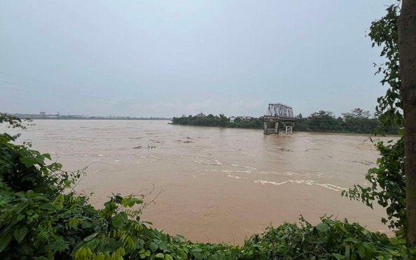
The flood peak on the Thao River at Yen Bai station is forecast to reach 34.30 m, about 2.30 m higher than alert level 3. This water level poses a risk of serious flooding in low-lying areas along the river.
Continuous heavy rain increases the risk of localized flooding in wards of Yen Bai city, Au Lau, Van Phu, Lao Cai, Cam Duong, Nam Cuong and many communes in Muong Khuong, Luc Yen, Yen Binh, Tran Yen districts... Flood depth can be from 0.3-0.5 m, even in some places it can exceed 1 m.
Not only flooding, heavy rain also increases the risk of flash floods on small rivers and streams. Steep hilly areas and road slopes are prone to landslides. Areas with weak ground in the province may experience subsidence, seriously affecting people's lives and travel.

-3b0672fed9b9276f8d02c910e92a6626.jpeg "Toàn cảnh thiệt hại bão số 10 trên địa bàn tỉnh Nghệ An")

-2620a890ce94f6bbc9a207f42b445e93.jpg "Công ty Điện lực Nghệ An huy động lực lượng khắc phục sự cố, cấp điện trở lại sớm nhất sau bão số 10")