Exhibition of maps and documents about the Paracel and Spratly Islands.
On the morning of August 22nd, at the Thong Nhat Hall in Ho Chi Minh City, the Ministry of Information and Communications and the People's Committee of Ho Chi Minh City officially opened the exhibition "Hoang Sa and Truong Sa of Vietnam – Historical Evidence".
This exhibition, held for the first time in the South, presents the latest documents on Vietnam's undeniable sovereignty over the Hoang Sa and Truong Sa archipelagos.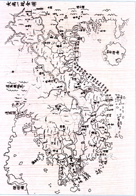
A copy of the Đại Nam nhất thống toàn đồ map from the Nguyễn dynasty, drawn around 1834-1840, shows "Hoàng Sa - Vạn Lý Trường Sa" as belonging to Vietnamese territory.
(Photo: Sports & Culture)
Nearly 200 maps and documents presented in the exhibition in Ho Chi Minh City represent only a small fraction of the historical and legal evidence. Just considering maps published by Vietnam, Western countries, and China throughout history, the number reaches nearly 300.
However, with its systematic display method, it is easy to compare, supplement, and verify the evidence to confirm that the Spratly Islands and the Paracel Islands belong to Vietnam. Therefore, even though this is the third exhibition held after those in Ha Tinh and Hanoi in June and July 2013, it has presented new evidence, introduced to the public for the first time, such as the 1917 Complete Atlas of China.
All the valuable materials in the exhibition will be handed over by the Ministry of Information and Communications to Ho Chi Minh City to continue introducing them not only to people in remote areas but also to localities in the South. In particular, these materials will be the theme of the Spring Book Fair in Ho Chi Minh City in the Year of the Horse 2014.
According to VTV - TH

