The Spratly and Paracel Islands belong to Vietnam.
(Baonghean) –Recently, the issue of sovereignty disputes in the South China Sea has negatively impacted relations among countries in the region, including the relationship between Vietnam and China. To help readers better understand Vietnam's sovereignty over the Spratly and Paracel Islands, Nghe An Online Newspaper presents this article to provide information on this issue.
Historical evidence
Over five centuries ago, the Vietnamese people established and exercised sovereignty over the Truong Sa and Hoang Sa archipelagos.
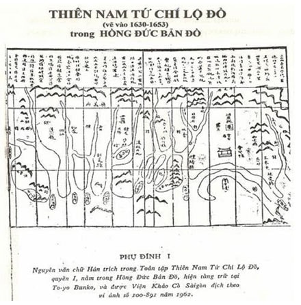
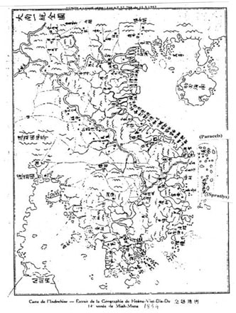
From the time of Emperor Lê Thánh Tông (1460-1497), in the "Complete Collection of Maps of the Four Branches of Thiên Nam," our ancestors drew maps of the Spratly and Paracel Islands, at which time the Paracel Islands were called "Golden Sandbank" and the Spratly Islands "Ten Thousand Miles of Sandbank" (the original is currently preserved in Tokyo, Japan). From the beginning of the 17th century, ancient Vietnamese geographical maps recorded "Golden Sandbank" to indicate that both the Paracel and Spratly Islands were Vietnamese territory. In the book "Phủ Biên Tạp Lục" by scholar Lê Quý Đôn, the Paracel and Spratly Islands were located in Quảng Ngãi province. The books "Lịch triều hiến chương loại chí" and "Hoàng Việt địa dư chí" by Phan Huy Chú (1782-1840) describe the administration of the Paracel and Spratly Islands by the Vietnamese feudal state. In the national history book "Đại Nam thực lục" of the Nguyễn dynasty, it is recorded that from 1711, Lord Nguyễn Phúc Chu sent people to measure the length, width, and depth of the Spratly Islands. In the Đại Nam nhất thống toàn đồ (a map of Vietnam completed in 1838), the Spratly Islands are depicted as part of Vietnamese territory. Vietnamese feudal dynasties conducted numerous geographical and resource surveys of the archipelago, the results of which have been documented in Vietnamese literature and history, published since the 17th century.
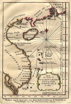
Western documents confirming Vietnam's sovereignty over the Paracel and Spratly Islands include: the Amphitrite ship's diary (1701) confirming that the Paracels were an archipelago belonging to Annam; Jean Baptiste Chaigneau's (1769-1825) *Le mémoire sur la Cochinchine*, written in the late years of Gia Long's reign (completed in 1820), affirming that in 1816, King Gia Long established Vietnamese sovereignty over the Paracels; Bishop Taberd's *An Nam Dai Quoc Hoa Do*, published in 1838; and Gutzlaff's *A of the Geographical Society of London* (1849) recording that the Annam government established tax collection boats and a small military camp to collect taxes in the Paracels... Even the *Hai Ngoai Ky Su* (Overseas Chronicle) by the Chinese author Thich Dai San states that Lord Nguyen sent ships to exploit resources from sunken ships in the Great Wall of the Spratly Islands.
The source material on the Paracel Islands from the Trinh dynasty in Northern Vietnam is primarily the Thien Nam Tu Chi Lo Do Thu or Toan Tap An Nam Lo, dated 1686, which contains maps and is the oldest document, clearly stating that the Nguyen dynasty sent 18 warships annually to exploit resources at Bai Cat Vang (Golden Sandbank). In Le Quy Don's Phu Bien Tap Luc (Miscellaneous Records of the Border Region), an ancient document that describes the Paracel Islands in detail, there is a passage mentioning that the Nguyen Lords established Dai Viet's sovereignty over the Paracel Islands through the activities of the Hoang Sa and Bac Hai fleets. The Nguyen Dynasty's imperial archives (19th century) are valuable documents currently stored at the Central Archives No. 1 in Hanoi. Through them, we find petitions and reports from court officials, ministries, and other agencies, as well as edicts from various emperors concerning the establishment of Vietnam's sovereignty over the Paracel Islands under the Nguyen Dynasty, such as exploration, surveying, mapping, and the placement of boundary markers. In the 5th year of the Thieu Tri reign (1845), an edict was issued to postpone the exploration, but it was later resumed. The Dai Nam Nhat Thong Chi, completed in 1882 (revised for the second time and printed in 1910), identifies the Paracel Islands as belonging to Quang Ngai province and further affirms the activities of the Hoang Sa and Bac Hai teams, which were under the joint management of the Hoang Sa team. Furthermore, ancient maps of Vietnam from the 17th to 19th centuries all depict the Golden Sandbanks, or Hoang Sa and the Great Wall of Vietnam, within Vietnam's territory.
Surveys of all ancient Chinese maps drawn by the Chinese themselves from 1909 onwards all identify Hainan Island as the southernmost point of China's southern border. After January 19, 1974, when China used force to occupy the Paracel Islands, they sent many archaeological teams to the islands of this archipelago and "discovered" many ancient artifacts such as ancient coins, porcelain, and carved stone objects on these islands, etc. However, these "discoveries" are not valuable in proving their sovereignty, while they themselves discovered on the northern side of the "Hoang Sa Temple" on Vinh Hung Island, also known as Phu Lam Island (Ile Boisée), clear evidence of Vietnam's establishment of sovereignty.
In summary, Vietnam possesses a very clear system of historical documents to affirm its sovereignty over the Paracel and Spratly Islands. These documents all demonstrate that Vietnam's sovereignty has been continuously asserted throughout the Dai Viet period, from the North-South conflict to the Tay Son dynasty, and then through the Nguyen dynasty (from 1802-1945). With so many official historical documents, it is sufficient to affirm that the Paracel and Spratly Islands belong to Vietnam's sovereignty.

Exercising sovereignty through Vietnamese dynasties
The Paracel Islands (comprising over 30 islands) are located between 15°45' and 17°15' North latitude and 111° and 113° East longitude, approximately 120 nautical miles from Ly Son Island, Quang Ngai province; their area is about 15,000 km². The Spratly Islands (comprising over 100 rocky islands, coral reefs, shoals, and submerged reefs scattered across the sea) are located between 6°50' and 12° North latitude and 111°3' and 117°2' East longitude, approximately 350 nautical miles from West to East and 360 nautical miles from North to South; their area is about 180,000 km², with a permanent surface area of about 10 km².2, located 248 nautical miles off the coast of Khanh Hoa province.
After the Nguyen Dynasty signed the treaty with France, the French administration in Indochina, acting as the protectorate, represented Vietnam's interests in international affairs and exercised sovereignty over the archipelago on behalf of Vietnam.
In 1887, France and the Qing Dynasty signed a convention delineating the land and sea borders between Vietnam and China, with the Paracel and Spratly Islands belonging to Vietnam.
On June 15, 1938, the Governor-General of Indochina, I. Brévie, signed Decree No. 156-SC, deciding on the administrative organization of the Paracel Islands, placing them under the jurisdiction of Thừa Thiên Province.
On December 21, 1933, Governor Krautheimer signed Decree No. 4702-CP, annexing the Spratly Islands to Ba Ria province.
On October 14, 1950, the French government officially handed over the Paracel and Spratly Islands to the Bảo Đại government for administration. On that day, the Chief Minister of Central Vietnam, General Phan Văn Giáo, personally presided over the handover ceremony held on the Paracel Islands.
In September 1951, at the San Francisco Conference, Prime Minister Bao Dai, Tran Van Huu, head of the Vietnamese delegation, declared Vietnam's sovereignty over the Paracel and Spratly Islands after Japan returned all the territories it occupied during World War II. At the conference, none of the 51 participating countries raised any objections.
Since July 20, 1954, when the Geneva Accords came into effect, Vietnam was divided in two by the 17th parallel, and the Spratly Islands, located south of the 17th parallel, came under the sovereignty of the Government of the Republic of Vietnam (RVN).
When the French expeditionary forces disembarked in Hai Phong in 1956, shortly after the French handed over the Paracel and Spratly Islands to the South Vietnamese government in Saigon, China, taking advantage of the ambiguity, invaded Phu Lam Island east of the Paracel Islands, forcing the Saigon army to retreat to the western part of the Paracel Islands. On August 22, 1956, the South Vietnamese Navy took over the Spratly Islands, held a flag-raising ceremony, and erected a stone pillar to mark its sovereignty.
On October 22, 1956, the Government of the Republic of Vietnam declared the Spratly Islands to be under the jurisdiction of Phuoc Tuy province (currently, the Spratly Islands are a district of Khanh Hoa province).
The Paracel Islands and the Spratly Islands are territories of Vietnam. In order to protect national sovereignty and territorial integrity in general, and maritime territories in particular, the State and people of Vietnam are doing and will continue to do their utmost in the legal struggle at all international legal forums, resolutely defending the territorial integrity of our sacred Fatherland.
Mai Thuan Ngon

