MH370 case: Australia releases sonar map of Indian Ocean bottom
More than nine months after the disappearance of Malaysia Airlines flight MH370, the Australian Transport Safety Bureau (ATSB) has released a stunning sonar map of the southern Indian Ocean seabed.
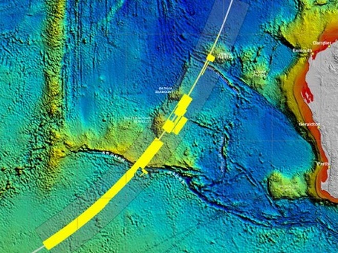 |
| Sonar image. Source: flightsearch.fugro.com |
| RELATED NEWS |
|---|
In addition to locating the aircraft, the underwater search aims to map the MH370 wreckage area to identify and prioritize the collection of specific parts of the aircraft, including the flight recorder, to assist Malaysia's investigation into the disappearance of the plane.
The ATSB said it had used data from the bathymetry survey to prepare an initial plan for continuing the underwater search for the missing aircraft.
This plan includes search timing, methods, procedures, safety precautions and initial search areas for various vessels...
The ATSB, which is coordinating the search operations, said it had searched more than 9,000 square kilometres of ocean floor and surveyed a search area of about 200,000 square kilometres.
On December 12, the ATSB released a video showing an animation of the seabed terrain and said it had mapped a search area roughly the size of Victoria. The Australian Geoscience Agency has provided advice, expertise and support to the ATSB.
Malaysia's Director-General of Civil Aviation Abdul Rahman Azharuddin said the video showed the difficulties faced by authorities.
"We want to show everyone that this is not an easy task. But we are determined to conduct a thorough survey to locate MH370. There is still a long way to go. We will continue our search efforts," Mr Azharuddin stressed.
Flight MH370, carrying 239 passengers and crew, lost contact on March 8 while en route from Kuala Lumpur to Beijing. It is believed to have crashed in the southern Indian Ocean, but no wreckage has yet been found.
According to Vietnam+


