Affected by tropical depression, Nghe An has heavy rain
(Baonghean.vn) - According to the assessment, on August 9, the tropical depression is likely to strengthen into a storm. The storm is forecast to head out to sea, moving in a northeast direction, then gradually change direction and enter the Gulf of Tonkin. In Nghe An, due to the influence of the tropical depression, there will be moderate rain, heavy rain and thunderstorms in some places.
On the night of August 8 and early morning of August 9, in the North Central region, there will be rain, moderate rain, heavy rain to very heavy rain and thunderstorms.
According toNorth Central Hydrometeorological Center, rainfall from 7pm to 7am on August 9 was generally 20-40mm, some places over 50mm such as: Hon Ngu 71mm, Cua Hoi 63.4mm, Mai Lam (Thanh Hoa) 67.2mm, Lang Chanh (Thanh Hoa) 64.6mm,...
Forecast on August 9, in the North Central region, there will be rain, moderate rain, heavy rain and thunderstorms in some places, with common rainfall of 10 - 30mm/24h, in some places over 40mm/24h;
Rainfall in Nghe An is commonly 10 - 30mm/24h, some places haverainfallhigher than 30mm/24h such as Vinh City, Cua Lo, Dien Chau, Quynh Luu, Yen Thanh, Thanh Chuong,...
During thunderstorms, there is a high possibility of tornadoes, lightning and strong gusts of wind; Heavy rain concentrated in a short period of time has a high risk of flash floods and landslides in the midlands and mountainous areas, and flooding in low-lying areas.
Warning level of natural disaster risk due to heavy rain, tornadoes, lightning and strong winds:Level 1.
NEWS ON TROPICAL LOW PRESSURE IN THE EAST SEA
According to the North Central Hydrometeorological Center, at 7:00 a.m. on August 9, the center of the tropical depression was at about 16.1 degrees North latitude; 112.3 degrees East longitude, in the Hoang Sa archipelago. The strongest wind near the center of the tropical depression was level 6 (39-49 km/h), gusting to level 8. The radius of strong winds of level 6, gusting to level 8 was about 80 km from the center of the tropical depression.
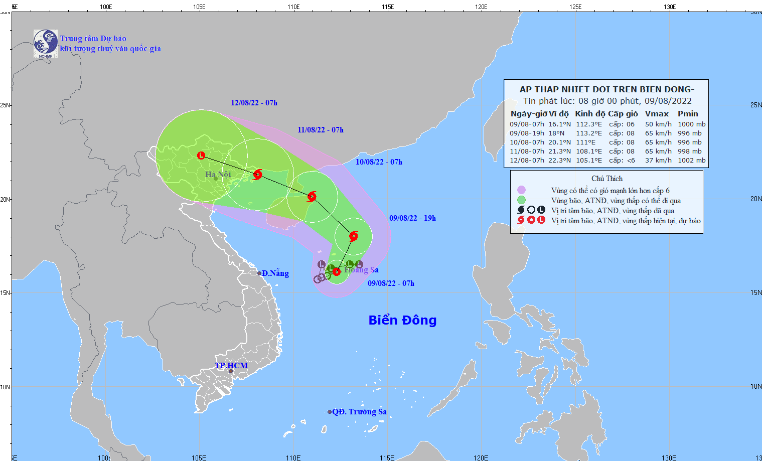 |
Position and direction of tropical depression at 7:00 a.m. August 9. |
It is forecasted that in the next 24 hours, the tropical depression will move in the direction of North-Northeast, then possibly change direction to North-Northwest, traveling about 15km per hour and possibly strengthening into a storm. At 7:00 a.m. on August 10, the center of the storm will be at about 20.1 degrees North latitude; 111.0 degrees East longitude, in the area northeast of Hainan Island (China). The strongest wind in the area neareye of the stormlevel 8 wind (62-74km/h), level 10 gust.
Dangerous areas in the East Sea in the next 24 hours (strong winds of level 6 or higher, gusts of level 8 or higher): North of latitude 14.5 degrees North; from longitude 109.0 to 115.0 degrees East. All vessels operating in the dangerous area are at high risk of being affected by strong gusts of wind and big waves. Disaster risk level:level 3
In the next 24 to 48 hours, the storm will move in a West-Northwest direction, traveling 10-15km per hour. At 7:00 a.m. on August 11, the center of the storm was at about 21.3 degrees North latitude; 108.1 degrees East longitude, in the northern area of Bac Bo Gulf, about 80km southeast of Mong Cai (Quang Ninh). The strongest wind near the center of the storm is level 8 (62-74km/h), gusting to level 10.
During the next 48 to 72 hours, the storm will move in the West-Northwest direction at 10-15km per hour and is likely to gradually weaken.
Warning of strong winds and high waves at sea: Due to the influence of a tropical depression, which may later strengthen into a storm, the North East Sea area (including the waters of the Hoang Sa archipelago) will have strong winds of level 6-7, near the storm center strong winds of level 8, gusts of level 10, waves from 4.0-6.0m high, rough seas.