Tropical depression in the East Sea is likely to strengthen into a storm
(Baonghean.vn) - According to the National Center for Hydro-Meteorological Forecasting, in the next 24 to 48 hours, the storm is forecast to continue moving rapidly in a westerly direction, traveling 30-35km per hour, directly affecting the coastal provinces of the Northeast, the Northern Delta and the North Central region.
1. Tropical depression near the coast
4 o'clock, the center of the tropical depression is located at about 18.4 degrees North latitude; 106.3 degrees East longitude, right on the coast of the provinces from Nghe An to Ha Tinh. The strongest wind near the center of the tropical depression is level 6 (40-50km/hour),level 8 jerk. The range of strong winds of level 6, gusting to level 8 is about 50km from the center of the tropical depression.
Forecast for the next 12 hours,The tropical depression moved slowly in the West-Southwest direction at about 5km per hour and gradually weakened into a low-pressure area. By 4pm on July 18, the center of the low-pressure area was at about 18.3 degrees North latitude; 105.9 degrees East longitude, right on the coast of Nghe An-Ha Tinh provinces. The strongest wind near the center of the low-pressure area decreased to below level 6 (below 40km/h).
Due to the influence of the tropical depression, this morning and afternoon (July 17) in the Gulf of Tonkin, there will continue to be showers and thunderstorms, with strong winds of level 6.level 8 jerk, waves 2-3m high. Rough sea.Disaster risk level due to near-shore tropical depression: level 3
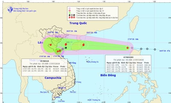 |
| Location and path of the storm. Photo: National Center for Hydro-Meteorological Forecasting |
2. Tropical depression in the East Sea
Early this morning (July 17), a tropical depression near the East Sea has crossed the north of Luzon Island (Philippines) and entered the north of the East Sea.
4 o'clock, the center of the tropical depression is located at about 19.0 degrees North latitude; 119.7 degrees East longitude, about 100km northwest of Luzon Island (Philippines). The strongest wind near the center of the tropical depression is level 7 (50-60km/hour).level 9.
Forecast for the next 24 hours,The tropical depression is moving rapidly in the West Northwest direction, traveling 30-35km per hour and has the potential to strengthen into a storm.At 4:00 a.m. on July 18, the center of the storm was located at about 19.6 degrees North latitude; 111.0 degrees East longitude, just east of Hainan Island, about 550km east of the coast of the provinces from Hai Phong to Ha Tinh. The strongest wind near the center of the storm was level 8 (60-75km/h).level 10. The range of strong winds of level 6, gusting to level 8 or higher is about 100km from the center of the storm.
Due to the influence of a tropical depression, which is likely to strengthen into a storm, there will be strong thunderstorms in the North East Sea; winds will gradually increase to level 7, then increase to level 8.level 10; rough seas.
Dangerous areas in the East Sea in the next 24 hours: (strong wind level 6 or higher) from latitude 17.5 to 21.5 degrees North; east of longitude 109.0 degrees East.
Forecast for the next 24 to 48 hours, the storm continued to move rapidly in the West direction, traveling 30-35km per hour, directly affecting the coastal provinces of the Northeast, the Northern Delta and the North Central region, then weakened into a tropical depression. At 04:00 on July 19, the center of the tropical depression was at about 19.6 degrees North latitude; 104.5 degrees East longitude, on the mainland of the North Central region. The strongest wind near the center of the tropical depression was level 7 (50-60km/hour),level 9. The range of strong winds of level 6, gusting to level 8 or higher is about 100km from the center of the storm.
Forecast for the next 48 to 72 hours, the tropical depression continued to move rapidly to the West, weakening and gradually dissipating.Disaster risk level due to tropical depression in the East Sea: level 3.
Besides, due to the influence of the tropical convergence zone combined with the strong southwest monsoon, during today and tonight, in the East Sea (including the waters of Hoang Sa and Truong Sa archipelagos), the waters from Binh Thuan to Ca Mau, Ca Mau to Kien Giang and the Gulf of Thailand will continue to have heavy thunderstorms. During the thunderstorms, there is a possibility of tornadoes and strong gusts of wind.
The South China Sea area (including the Truong Sa archipelago), the sea area from Binh Thuan to Ca Mau during the day and tonight will continue to have strong southwest winds of level 6, sometimes level 7, gusting to level 9, waves from 2-4m high; rough seas.Disaster risk level due to strong winds and big waves: level 1.
WARNING OF FLASH FLOODS, LANDSCAPES AND FLOODING IN THANH HOA - NGHE AN - HA TINH
In the past 3 hours, in the provinces from Thanh Hoa to Ha Tinh, there has been moderate rain, heavy rain, and in some places very heavy rain such as Hoa Duyet 95mm, Linh Cam 66mm, Cho Trang 76mm, Huong Quang 60mm, Huong Dien 70mm.
It is forecasted that in the next 3-6 hours, the above provinces will continue to have moderate to heavy rain, especially in Ha Tinh, some places will have very heavy rain.
Warning:In the next 3-6 hours, there is a high risk of flash floods, landslides and inundation in low-lying areas in the provinces from Thanh Hoa to Ha Tinh.Especially the districts: Huong Son, Vu Quang, Huong Khe, Duc Tho.Disaster risk level: Level 2.

.jpeg "Công ty TNHH MTV Lâm Nông nghiệp Sông Hiếu thiệt hại lớn sau mưa bão")


