The North and North Central regions continue to have heavy rain, some places have very heavy rain.
(Baonghean.vn) - According to the National Center for Hydro-Meteorological Forecasting, the heavy rain in the North and North Central regions is likely to last until around August 1 with the natural disaster risk level at level 1.
Currently (July 29):The tropical convergence zone with its axis passing through the area between the Southern Delta and the North Central region continues to be active. Due to the influence of the tropical convergence zone, last night (July 28), in the Northern and North Central provinces, there was rain, moderate rain, and heavy rain in some places (rainfall as of 1:00 a.m. on July 29) such as in Bac Me (Ha Giang) 27mm, Vinh Yen (Vinh Phuc) 28mm, Minh Dai (Phu Tho) 23mm, Bai Chay (Quang Ninh) 29mm, Quynh Luu (Nghe An) 27mm, ...
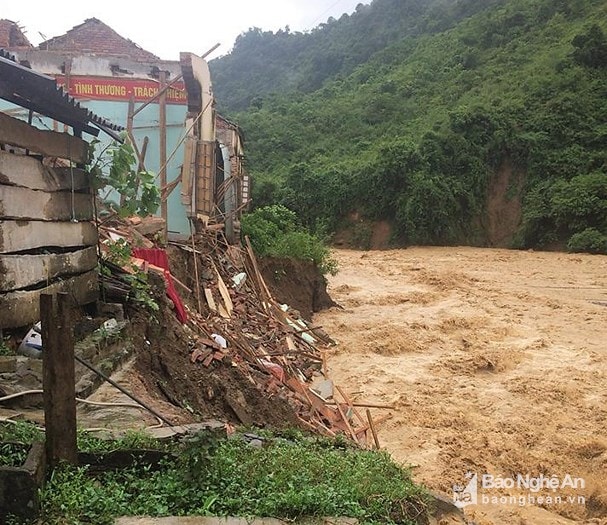 |
| Muong Ai Primary School, Ky Son District (Nghe An) was collapsed and swept away by floods. Photo: Hung Phong |
Forecast:Due to the influence of the tropical convergence zone, today and tonight (July 29), in the Northern and North Central provinces, there will be rain, some places will have moderate rain, heavy rain and scattered thunderstorms; in the Northern Delta and coastal areas, the provinces of Son La, Hoa Binh, Phu Tho, Quang Ninh, Hai Phong, Thanh Hoa will have moderate to heavy rain, some places will have very heavy rain. During the thunderstorm, there is a possibility of tornadoes, whirlwinds and strong gusts of wind.
Warning:Heavy rains in the North and Thanh Hoa are likely to last until around August 1st, and will gradually decrease after August 1st. Disaster risk level due to heavy rains: level 1.
Chernh baholu:From July 29-31, a flood will occur in the upper reaches of the Red River-Thai Binh River system with the following flood amplitudes on the following rivers: on the upper reaches of the Da River and Thao River from 2-3m, on the upper reaches of the Thai Binh River from 3-4m, on the lower reaches of the Thai Binh River from 1-2m, on the upper reaches of the Lo River from 3-4m, on the Hoang Long River from 1-2m. During this flood, the flood peak on the upper reaches of the Thao River will be at level BĐ1-BĐ2, on the upper reaches of the Lo River at level BĐ1, on the Hoang Long River at level BĐ1-BĐ2, on the upper reaches of the rivers in Thanh Hoa will be at level BĐ1-BĐ2, with some places above alert level 2.
Chernh baholutheyest, syestllivelandt:There is a very high risk of flash floods and landslides in the northern mountainous areas, especially in provinces such as Lai Chau, Son La, Dien Bien, Hoa Binh, Lao Cai, Ha Giang, Yen Bai, Tuyen Quang, Lang Son, Cao Bang, Quang Ninh, Thanh Hoa.(It is necessary to pay attention to detailed flash flood and landslide warning information to the district level in flash flood and landslide warning bulletins).
Besides, due to the influence of the tropical convergence zone combined with the strong southwest monsoon, during the day and tonight (July 29), in the South East Sea area (including the sea area of Truong Sa archipelago) and the sea area from Binh Thuan to Ca Mau, there will continue to be strong southwest winds at level 5, sometimes level 6, gusting to level 8, waves 2-3m high; rough seas.Disaster risk level: level 1-2.
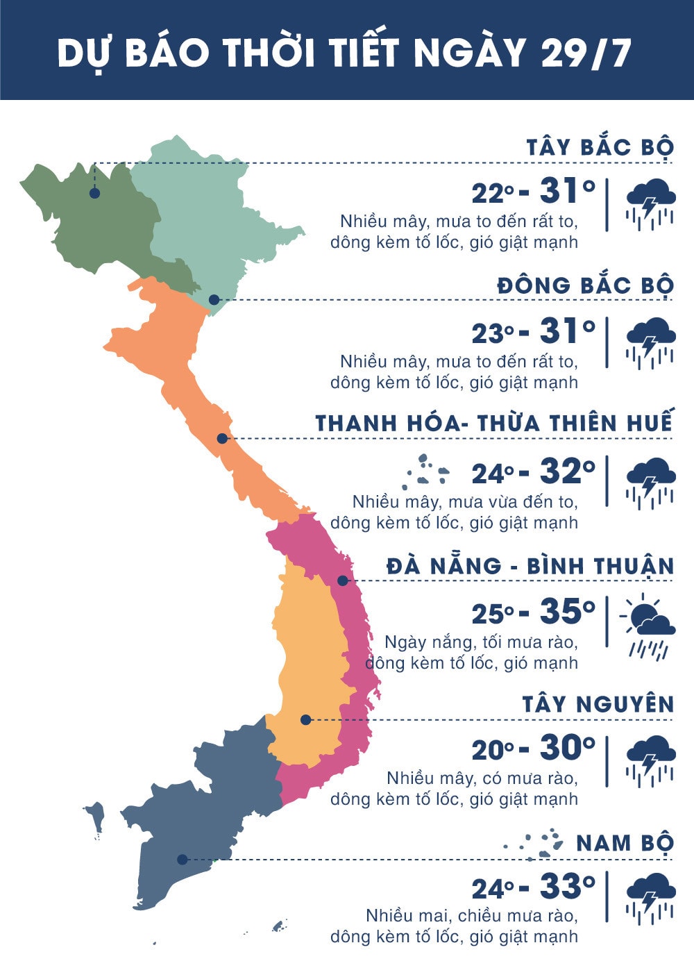 |
| Temperature forecast for regions across the country on July 29, 2018. Photo: news.zing.vn |
.jpg "Oằn mình dọn rác lòng hồ thủy điện Bản Vẽ sau nhiều trận mưa lũ liên tiếp")

")


