A powerful storm of level 8 is approaching the East Sea.
On the morning of October 6th, the tropical depression strengthened into Typhoon Aere and is likely to affect the northern and central regions of Vietnam.
According to the National Center for Hydro-Meteorological Forecasting, at 2 AM, the typhoon was approximately 200 km north-northeast of Luzon Island, with maximum wind speeds of 75 km/h, equivalent to level 8. Moving at a speed of 20-25 km/h in a west-northwest direction, on October 7th, Aere will be approximately 680 km northeast of the Paracel Islands, with wind intensity increasing by one level, reaching a maximum of 90 km/h.
 |
The storm's path at 2 AM, as predicted by the National Center for Hydrometeorology. Photo: NCHMF. |
Subsequently, the storm continued to intensify, and by October 8th, it was approximately 550 km northeast of the Hoang Sa archipelago, with maximum wind speeds of 100 km/h (level 10).
The storm's circulation is causing strong winds of force 8 in the northern part of the South China Sea. Additionally, due to the southwest monsoon, the central and southern parts of the South China Sea (including the waters around the Spratly Islands), the sea area from Binh Thuan to Ca Mau, Ca Mau to Kien Giang, and the Gulf of Thailand are experiencing thunderstorms with strong gusts of wind and waves of 1.5 to 2.5 meters.
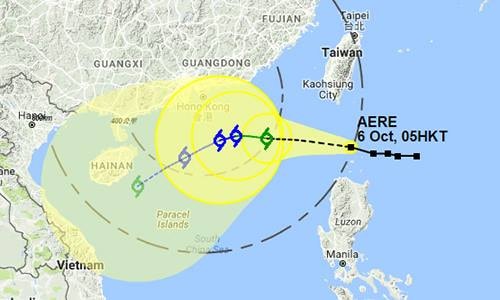 |
Hong Kong Television forecasts the storm's path. Photo: HKO |
This is the fifth storm to appear in the East Sea this year. Experts predict that from now until the end of the year, there will be about 2-3 more storms and tropical depressions affecting Vietnam, with the affected area being from the central region southward.
According to VNE
| RELATED NEWS |
|---|

