Storm Noru increases to level 14 as it approaches Hoang Sa
At 4:00 a.m. on September 27, storm Noru in the sea southeast of Hoang Sa archipelago, strongest wind speed 166 km/h, level 14, gusting up two levels.
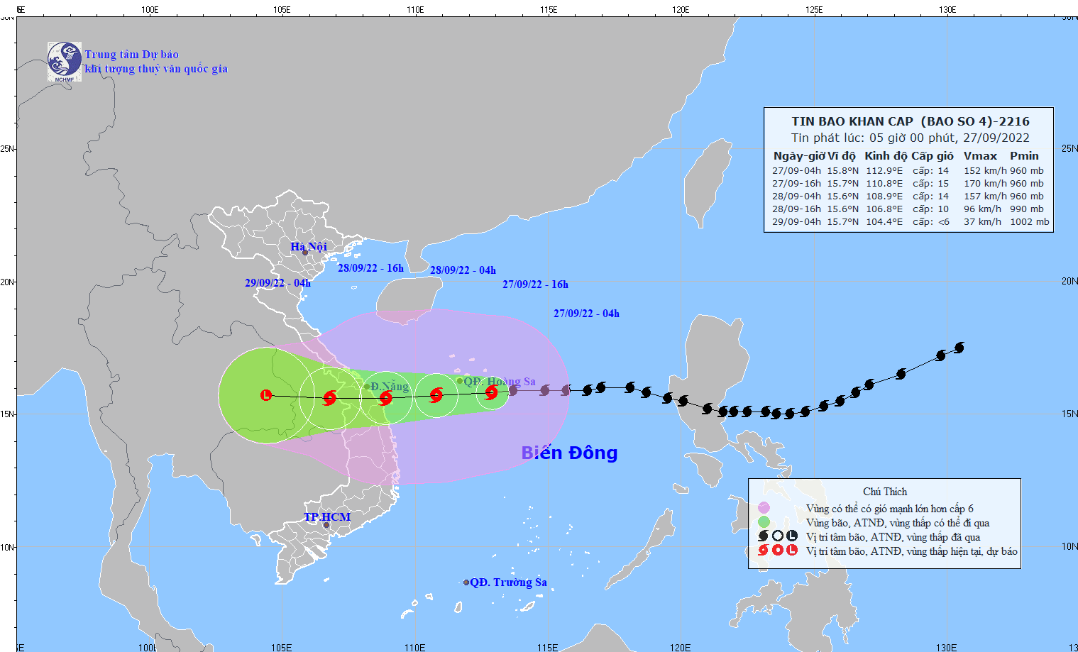 |
Path of storm No. 4. Source: National Center for Hydro-Meteorological Forecasting. |
At 4:00 a.m. on September 27, the storm center is located at about 15.8 degrees North latitude; 112.9 degrees East longitude, in the sea southeast of Hoang Sa archipelago. The strongest wind near the storm center is level 14 (150-166km/hour),level 16. The radius of strong winds from level 6, gusting from level 8 or higher is about 250km from the center of the storm; the radius of strong winds from level 10, gusting from level 12 or higher is about 150km from the center of the storm.
Forecast for the next 12 hours,The storm is moving mainly in a westerly direction, traveling 20-25km per hour and is likely to strengthen. At 4:00 p.m. on September 27, the center of the storm was at about 15.7 degrees North latitude; 110.8 degrees East longitude, about 300km from Da Nang, about 250km from Quang Nam, and about 240km from Quang Ngai to the East. The strongest wind near the center of the storm is level 14-15 (150-183km/hour).level 17.
Forecast for the next 12 to 24 hours,The storm is moving mainly in a westerly direction, traveling 20-25km per hour. At 4:00 a.m. on September 28, the storm's center was at about 15.7 degrees North latitude; 108.9 degrees East longitude, on the coastal areas of Quang Tri-Binh Dinh provinces. The strongest wind near the storm's center is level 14 (150-166km/hour).level 16.Dangerous areas in the East Sea in the next 24 hours (strong winds from level 6 or higher, gusts from level 8 or higher):from latitude 12.5 to 19.5 degrees North; west of longitude 116.0 degrees East. All vessels operating in the danger zone are at high risk of being affected by strong winds, large waves and whirlwinds.Disaster risk level: level 4.
In the next 24 to 48 hours,The storm moved mainly westward, traveling about 20km per hour, entering the mainland of the Central Central region, gradually weakening into a tropical depression, then continuing to weaken into a low pressure area over the Thailand region. The strongest wind in the center of the low pressure area decreased to below level 6 (below 39km/h).
Dangerous areas at sea in the next 24 to 48 hours (strong winds from level 6 or higher, gusts from level 8 or higher):from latitude 12.5 to 19.5 degrees North; west of longitude 112.5 degrees East. All ships, dykes, seawalls, aquaculture areas and other activities in the above sea areas are at high risk of being affected by strong winds, big waves, whirlwinds and storm surges.Disaster risk level: level 4.
Warning of strong winds, big waves at sea, storm surge in coastal areas:The southwestern sea area of the North East Sea (including the sea area of the Hoang Sa archipelago), the northwestern sea area of the Central East Sea has storms and rain, strong winds of level 8-10, then increasing to level 11-12, the area near the storm center level 14-15,level 17Waves 9-11m high, rough seas. The South East Sea area (including the Truong Sa archipelago), the area from Binh Thuan to Ca Mau and the Gulf of Tonkin have strong winds of level 6-7, gusts of level 8-9, waves 3-4m high, rough seas.
From the morning of September 27, the sea off the coast of the area from Quang Binh to Ninh Thuan (including Con Co, Cu Lao Cham, and Ly Son island districts) had strong winds of level 8-9, then increasing to level 10-11, near the storm center strong winds of level 13-14, gusting to level 16; waves 8-10m high, rough seas.
From the afternoon of September 27, coastal waters from Thua Thien Hue to Binh Dinh will have strong winds of level 9-10, then increasing to level 11-12, near the storm center will have strong winds of level 13-14, gusting to level 16; waves 3-5m high, near the storm center 6-8m. In the area from Quang Binh to Quang Ngai, storm surge is 1.0-1.5m high; total water level (storm surge combined with tide) is 2.0-2.5m high, with a high risk of flooding in low-lying coastal areas and river mouths due to storm surge and big waves.
Strong wind warning on land:From the evening and night of September 27, coastal areas of Thua Thien Hue, Da Nang, Quang Nam, Quang Ngai, Binh Dinh will have strong winds of level 9-10, areas near the storm center will have strong winds of level 12-13, gusts of level 14-15, areas further inland will have strong winds of level 8-9, gusts of level 12-13; areas of Quang Binh, Quang Tri, Phu Yen will have strong winds of level 6, then increasing to level 7-8, gusts of level 9-10. From early morning of September 28, areas of Kon Tum, Gia Lai will have winds gradually increasing to level 6, then increasing to level 7-8, in some places level 9, gusts of level 11.
Heavy rain warning:From September 27 to September 28, Quang Tri, Thua Thien Hue, Da Nang, Quang Nam, Quang Ngai, Kon Tum will have very heavy rain with average rainfall of 250-350mm/period, some places over 450mm/period; Quang Binh, Binh Dinh, Gia Lai will have heavy to very heavy rain with average rainfall of 100-200mm/period, some places over 300mm/period. From September 28, heavy rain tends to spread to the North Central region and the Southern Red River Delta.
Disaster risk level:Thua Thien Hue, Da Nang, Quang Nam, Quang Ngai, Binh Dinh:level 4;Quang Tri, Phu Yen, Kon Tum, Gia Lai:level 3
News broadcast at: 05:00
.jpg "Trong tâm bão số 5: Nơi ấm áp nghĩa đồng bào, chỗ kiếm tiền khó hiểu")


