Typhoon No. 2 reached level 8 in strength, with gusts up to level 10.
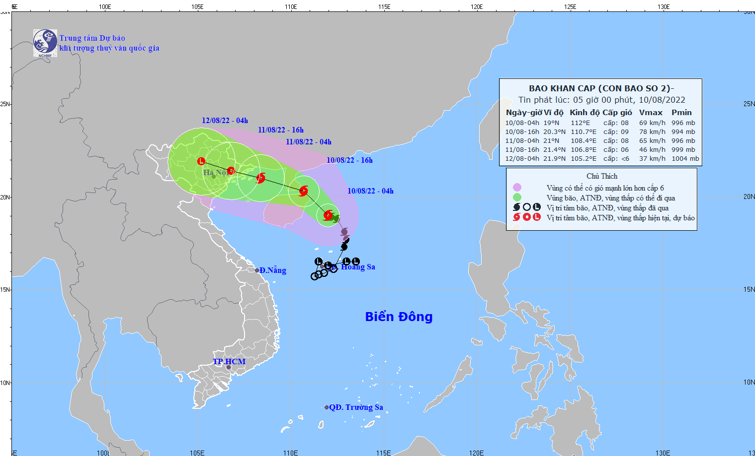
According to the National Center for Meteorological and Hydrological Forecasting, at 4:00 AM this morning, August 10th, Typhoon No. 2 was located approximately 160km east of Hainan Island (China), with maximum wind speeds near the center of the typhoon reaching level 8, gusting to level 10.
 |
The location of Typhoon No. 2 at 4:00 AM this morning, August 10th. Photo: National Center for Hydro-Meteorological Forecasting. |
At 4:00 AM on August 10th,location of the storm's centerLocated at approximately 19.0 degrees North latitude and 112.0 degrees East longitude, about 160km east of Hainan Island (China). The strongest winds near the center of the storm are at level 8 (62-74 km/h), with gusts up to level 10. The radius of strong winds at level 6, with gusts up to level 8, is about 110km from the storm's center.
Forecast for the next 12 hoursThe storm is moving mainly in a North-Northwest direction at a speed of 15-20 km/h and is likely to intensify. By 4 PM on August 10th, the storm's center was located at approximately 20.3 degrees North latitude; 110.7 degrees East longitude, over the sea southeast of the Leizhou Peninsula (China). The strongest winds near the storm's center were at force 8-9 (62-88 km/h), with gusts up to force 11.
Forecast for the next 12 to 24 hoursThe storm is moving in a west-northwest direction at a speed of 15-20 km/h. By 04:00 on August 11th, the storm's center was located at approximately 21.0 degrees North latitude and 108.4 degrees East longitude, in the northern part of the Gulf of Tonkin, about 80 km southeast of Mong Cai (Quang Ninh). The strongest winds near the storm's center were at level 8 (62-74 km/h), with gusts up to level 10.
Dangerous area at sea over the next 24 hours(Strong winds of level 6 or higher, gusts of level 8 or higher)North of latitude 17.5 degrees North; from longitude 106.5 to 113.5 degrees East. All vessels operating in this dangerous zone are at high risk of being affected by strong gusts of wind and high waves. Disaster risk level: level 3.
Over the next 24 to 48 hours,The storm moved in a west-northwest direction at approximately 15 km per hour, gradually weakening into a tropical depression and then a low-pressure area over the Viet Bac region of Northern Vietnam. The strongest winds at the center of the low-pressure area decreased to below level 6 (below 39 km/hour).
Hazardous area due to storm at sea over the next 24-36 hours.(Strong winds of level 6 or higher, gusts of level 8 or higher)Located north of 18.5 degrees North latitude and west of 111.0 degrees East longitude. All vessels operating in the hazardous zone and aquaculture areas are at high risk of being affected by strong gusts of wind and large waves. Disaster risk level: level 3.
Warning of strong winds and high waves at sea:In the northern South China Sea (including the waters around the Paracel Islands), winds will be strong at force 6-7, reaching force 8-9 near the storm's center, with gusts up to force 11. Sea waves will be 4.0-6.0 meters high, resulting in very rough seas. In the northern Gulf of Tonkin (including Co To and Bach Long Vi island districts), winds will gradually strengthen from tonight (August 10th) to force 6, then increase to force 7, reaching force 8 near the storm's center, with gusts up to force 10. Sea waves will be 2.0-4.0 meters high, resulting in rough seas.
Due to the strong southwest monsoon, the sea area from Binh Dinh to Ca Mau, the central and southern parts of the East Sea (including the sea area around the Truong Sa archipelago) will experience strong winds of level 6, sometimes level 7, gusting to level 9, with waves 2.0-4.0m high and rough seas.
Strong wind warning on land:On the night of August 10th and the day of August 11th, the coastal areas of Quang Ninh and Hai Phong are likely to experience strong winds of level 6-7, gusting to level 9.
Heavy rain warning:From this evening (August 10th) until around August 12th, the Northern region, Thanh Hoa and Nghe An will experience moderate to heavy rain and thunderstorms, with some areas experiencing very heavy rain. The rainfall amount will generally be 100-200mm/period, with some areas exceeding 250mm/period.

