Risk of heavy rain, flooding, and landslides in Nghe An due to the impact of Typhoon No. 2.
The General Department of Meteorology and Hydrology held two online meetings on July 22nd to warn about the impact of Typhoon No. 2. For Nghe An province, heavy rain, rising water levels, and landslides are predicted in many districts and towns. Mr. Le Duc Cuong, Deputy Director of the North Central Region Meteorological and Hydrological Station, provided further clarification on this matter.

PV: Could you please provide an update on the forecast and response to Typhoon Prapiroon (Typhoon No. 2)?
Mr. Le Duc Cuong:Forecasts regarding the development and trajectory of Typhoon No. 2, internationally named Prapiroon, are updated hourly and promptly disseminated to localities nationwide. On July 22nd, the General Department of Meteorology and Hydrology held two online meetings with meteorological and hydrological agencies and stations in the Northern and North Central regions to discuss the development of Typhoon No. 2. This included warnings for affected localities, including Nghe An province.
In summary, over the past 24 hours, the North Central region experienced showers and scattered thunderstorms, with some areas receiving heavy rain. Specifically, the western mountainous areas of Nghe An province experienced heavy to very heavy rain and thunderstorms, with rainfall measured from 7:00 AM on July 21st to 7:00 AM on July 22nd generally ranging from 60 to 120 mm. Some areas received even higher amounts, such as Chau Khe (Con Cuong) with 162 mm and Cam Lam with 149.8 mm; and Yen Na 1 in Tuong Duong with 167.8 mm.
PV:So, what are the notable weather developments in localities across Nghe An province in the coming days?
Mr. Le Duc Cuong:The developments of Typhoon No. 2 are basically consistent with the warnings of the National Center for Meteorological and Hydrological Forecasting.
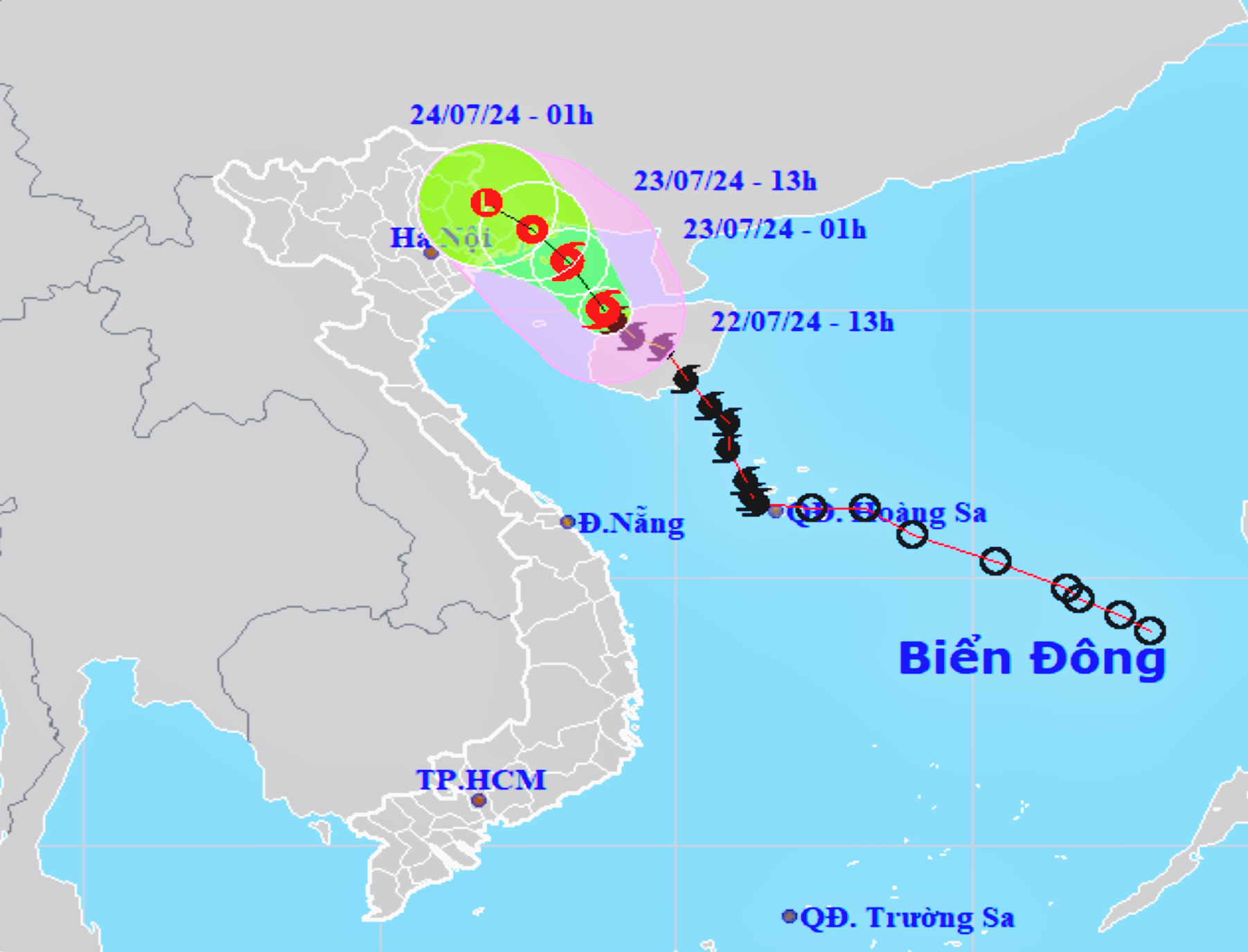
Specifically, regarding the upcoming developments of Typhoon No. 2 and detailed assessments for the North Central region, due to the influence of a tropical convergence zone with its axis passing through the area between the southern part of the Northern Delta and the North Central region, connected to the center of Typhoon No. 2 in the East Sea, shifting its axis northward, from the night of July 22nd to 23rd, Thanh Hoa and northern Nghe An will experience moderate to heavy rain, with some areas experiencing very heavy rain and thunderstorms. Southern Nghe An and Ha Tinh are forecast to have showers, with some areas experiencing moderate to heavy rain and thunderstorms. Note that during thunderstorms, there is a high possibility of tornadoes, strong gusts of wind, hail, and lightning.
The forecast indicates that the total rainfall in Thanh Hoa, Nghe An, and Ha Tinh provinces is likely to reach 40-80 mm. Specifically: Thanh Hoa: Generally 40-70 mm, with some areas exceeding 100 mm. Nghe An: Generally 20-50 mm, with some areas exceeding 80 mm. Ha Tinh: Generally 10-30 mm, with some areas exceeding 50 mm. In Nghe An, widespread rain is forecast from the night of July 22nd to July 24th. During thunderstorms, be wary of strong winds, hail, and gusts. The forecast for rainfall in the coastal plains is 40-70 mm, with some areas exceeding 80 mm. The forecast for the midland and mountainous areas is 30-80 mm, with some areas exceeding 100 mm.
We also have assessments of the flood situation on the rivers through hourly updated monitoring data. During this storm, from July 23-25, water levels in the upper reaches of rivers in Thanh Hoa and Nghe An provinces fluctuated upwards. Water levels on the rivers are close to alarm level 1. Water inflow into reservoirs in the area is gradually increasing, but currently, water levels in the reservoirs are still lower than normal levels.

However, the unpredictable nature of storms, rain, and wind can cause serious consequences, especially in areas along rivers and streams, and in mountainous regions where flash floods and landslides may occur. In particular, there is a high risk of flash floods and landslides in the western mountainous districts of Thanh Hoa and Nghe An provinces from July 23rd to 25th. This is accompanied by a forecast of widespread heavy rain in Nghe An from July 23rd to 24th; during thunderstorms, be wary of strong winds, hail, and gusts. The predicted rainfall is generally 40-70 mm in coastal plains, with some areas exceeding 80 mm. Mid-hill and mountainous areas are expected to receive 30-80 mm, with some areas exceeding 100 mm.

PV:Thank you, sir!

