Bão số 5 đổ bộ Quảng Bình đến Thừa Thiên Huế, Nghệ An có mưa đến 200mm
(Baonghean.vn) - At 10:00 a.m. on September 18, storm No. 5 made landfall in the provinces of Quang Binh and Thua Thien Hue and weakened into a tropical depression.
Due to the influence of cold air, combined with the circulation north of storm No. 5, coastal areas in the North Central region have observed strong winds of level 4 and level 5, with some places having gusts of level 8 and level 9.
Rainfall from 7pm yesterday to 10am this morning (September 18), in Nghe An and Ha Tinh generally: 50 - 130mm, some places more like Vinh 126mm.
10 o'clock, the center of the tropical depression is located at about 16.6 degrees North latitude; 107.2 degrees East longitude on the mainland of Quang Tri and Thua Thien Hue provinces. The strongest wind near the center of the tropical depression is level 6-7 (40-60km/hour),level 8 jerk.
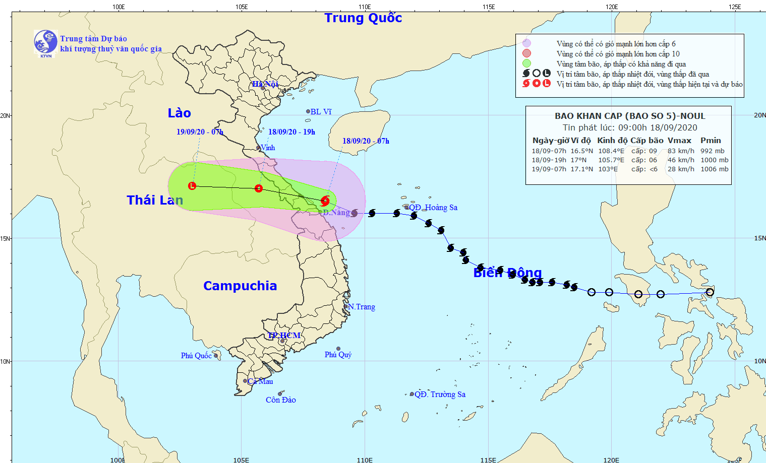 |
| The path of storm No. 5 at 8:00 a.m. on September 18. Photo: North Central Hydrometeorological Station |
Forecast for the next 12 hours,The tropical depression moved westward at about 25km per hour and weakened into a low pressure area over central Laos.Disaster risk level: Level 3
Regarding the weather situation in the North Central region, this afternoon (September 18), the sea area from Thanh Hoa to Ha Tinh has strong winds of level 6, level 7. Coastal waves in the Nghe An - Ha Tinh area are from 3.0 - 5.0m high, offshore areas are 4.0 - 6.0m high.
On land, coastal districts in the south of Ha Tinh have strong winds of level 5 - level 6, gusting to level 7.
From now until the end of September 19, due to the influence of the strengthening of the continental cold high pressure and the northern edge of the circulation of storm No. 5, the North Central region will have moderate rain, heavy rain, and in some places very heavy rain and thunderstorms. The total rainfall for the entire period (from September 18 to the end of September 19) in Nghe An is likely to be from 100 - 200mm.
Thunderstorms may cause tornadoes, lightning, hail and strong gusts of wind; Localized heavy rain in a short period of time causes a high risk of flash floods and landslides in midlands and mountainous areas.
Due to the impact of the storm, on the night of September 17 and early morning of September 18, the coastal plains of Nghe An province experienced heavy to very heavy rain. Some roads in Vinh city were flooded. The heavy rain during rush hour caused many roads to be partially blocked.
To cope with storm No. 5, the People's Committee of Nghe An province has continuously issued urgent dispatches, requesting localities to proactively deploy storm prevention plans. The Nghe An Provincial Military Command and the Provincial Border Guard have also deployed plans to prevent and combat storm No. 5.
 |
| Le Hong Phong Street was deeply flooded in the rain on the morning of September 18. Photo: Duc Thang |
Accordingly, border guards and boat owners must inform vessels operating at sea of the storm's direction so they can proactively avoid and escape from dangerous areas; maintain regular contact with boat and ship owners to promptly handle bad situations that may arise...
 |
| Nghe An fishermen's boats come ashore to avoid the storm. |
As of 5am on September 18, 3,299 vessels had returned to safe anchorage. There were still 84 vessels operating at sea. All of the above vessels had received notice of the location and direction of storm No. 5 and were proactively taking precautions.
Forecast, tThis afternoon and evening (September 18), the sea area from Thanh Hoa to Ha Tinh has strong winds of level 6, level 7; The sea area in the South has strong winds of level 8 - level 9, gusts of level 10. The sea is rough. The waves along the coast of Nghe An - Ha Tinh are 3.0 - 5.0m high, offshore are 4.0 - 6.0m. The coastal districts in the South of Ha Tinh have strong winds of level 5 - level 6, gusts of level 7.
From now until the end of September 19, due to the influence of the strengthening of the continental cold high pressure and the northern edge of the circulation of storm No. 5, in the North Central region there will be moderate rain, heavy rain, and in some places very heavy rain and thunderstorms. The total rainfall for the whole period (from September 18 to the end of September 19) is likely to reach: Thanh Hoa: 70 - 150mm;Nghe An: 100 - 200mm;Ha Tinh: 200 - 300mm; locally over 300mm.
Thunderstorms may cause tornadoes, lightning, hail and strong gusts of wind; Localized heavy rain in a short period of time causes a high risk of flash floods and landslides in midlands and mountainous areas.


