Storm No. 5 with level 10 gusts approaches Quang Ninh, super storm MANGKHUT with gusts above level 17
(Baonghean.vn) - According to the National Center for Hydro-Meteorological Forecasting, from tonight (September 13) to September 14, there will be rain, moderate rain in the Northeast; in particular, there will be moderate rain, heavy rain in the Northeast and Viet Bac regions.
1. Emergency Storm (Storm No. 5)
At 4:00 a.m. on September 13,The center of the storm is located at about 21.0 degrees North latitude; 111.5 degrees East longitude, about 400km east of Mong Cai (Quang Ninh). The strongest wind near the center of the storm is level 8 (60-75km/hour).level 10. The range of strong winds of level 6, gusting to level 8 or higher is about 80km from the center of the storm.
Forecast for the next 12 hours,The storm moved in a West Northwest direction, about 15-20km per hour, entered the northern area of Bac Bo Gulf and gradually weakened into a tropical depression.
At 4:00 p.m. on September 13, the center of the tropical depression was at about 21.2 degrees North latitude; 109.3 degrees East longitude, about 150km east of Mong Cai (Quang Ninh). The strongest wind near the center of the tropical depression was level 7 (50-60km/hour).level 9. The range of strong winds of level 6, gusting to level 8 or higher is about 70km from the center of the tropical depression.
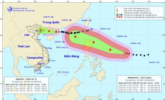 |
| The path and location of storm No. 5 and super typhoon MANGKHUT. Photo: National Center for Hydro-Meteorological Forecasting |
Forecast for the next 12 to 24 hours,The tropical depression moved in the West Northwest direction, traveling about 15-20km per hour, weakening into a low pressure area and entering the mainland from Quang Ninh to Hai Phong provinces.
At 4:00 a.m. on September 14, the center of the low pressure area was at about 21.5 degrees North latitude; 106.7 degrees East longitude, on the mainland of the Northeast region of the North. The strongest wind in the center of the low pressure area decreased to below level 6 (below 40km/h).
Due to the influence of the storm, the Northwestern sea area of the North East Sea today (September 13) will have stormy rain, strong winds of level 6-7, the area near the storm's eye will have level 8.level 10; rough seas. In the northern part of the Gulf of Tonkin, there will be showers and thunderstorms, strong winds of level 6-7, gusting to level 9. In Bach Long Vi and Co To island districts, from this afternoon, winds will gradually increase to level 6, then increase to level 7.level 9Waves in the Gulf of Tonkin are 2-3m high. The sea is rough.
Dangerous areas in the East Sea in the next 24 hours (strong wind level 6 or higher): North of latitude 19.0 degrees North.
Over the next 24 to 48 hours,The low pressure area continues to move in the West Northwest direction, about 20km per hour, going deep inland, weakening and gradually dissipating.
From tonight (September 13) to September 14, there will be rain, moderate rain in the Northeast; in particular, there will be moderate rain, heavy rain in the Northeast and Viet Bac. Total rainfall for the entire period is commonly from 50-100mm/period.Disaster risk level: level 3.
2. Super typhoon MANGKHUT
1:00 a.m. September 13, the center of storm MANGKHUT is located at about 14.4 degrees North latitude; 132.5 degrees East longitude. The strongest wind near the center of the storm is level 17 (200-220km/hour),jerk above level 17.
Forecast for the next 24 hours,The storm is moving in a West-Northwest direction, traveling about 20km per hour. At 1:00 a.m. on September 14, the center of the storm was at about 15.5 degrees North latitude; 128.1 degrees East longitude, about 690km east of Luzon Island (Philippines). The strongest wind near the center of the storm is level 17.jerk above level 17.
Over the next 24 to 48 hours,The storm is moving northwest at a speed of 20-25km per hour. At 1:00 a.m. on September 15, the center of the storm was at about 17.8 degrees North latitude; 123.0 degrees East longitude, about 110km east of Luzon Island. The strongest wind near the center of the storm is level 17.jerk above level 17.
Over the next 48 to 72 hours,The storm is moving in a West-Northwest direction, traveling about 25km per hour and entering the Northeast of the East Sea. At 1:00 a.m. on September 16, the center of the storm was at about 19.5 degrees North latitude; 117.4 degrees East longitude, about 690km east of Hainan Island (China). The strongest wind near the center of the storm is level 15.jerk above level 17.


