Warning: Storm No. 10 will make landfall in Nghe An
(Baonghean.vn)- According to the latest information received from the North Central Hydrometeorological Station, it is expected that by 1:00 p.m. on September 15, the center of the storm will be at about 18.0 degrees North latitude; 107.4 degrees East longitude, right on the sea of Nghe An - Quang Tri provinces.
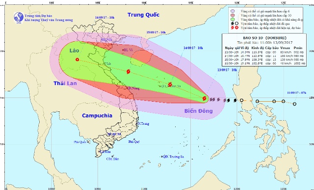 |
| Storm path. Photo: NCHMF |
Accordingly, currently, the Tropical Convergence Zone has an axis through the Central Central region connecting with storm No. 10 in the central East Sea area.
Storm No. 10 is moving mainly in the West-Northwest direction and is likely to affect the North Central region.
From the night of September 14, due to the influence of storm No. 10's circulation, the wind in the North Central Coast gradually increased to level 8, then increased to level 9-11, the area near the storm's center level 12-13, gusting to level 15; the sea was very rough. Disaster risk level: Level 4.
From the night of September 14 to 16, there will be a widespread heavy rain in the North Central region. The total rainfall for the period is likely to reach: 250 - 400mm, in some places over 400mm.
Beware of tornadoes, whirlwinds and strong winds; Heavy rain in a short period of time is likely to cause flash floods and landslides in the midlands and mountainous areas, and flooding in low-lying areas.
13:00 September 13, the eye of the storm is located at about 15.2 degrees North latitude; 116.0 degrees East longitude, about 450km East Southeast of Hoang Sa archipelago. The strongest wind near the eye of the storm is level 9 (75 to 90 km/h), gusting to level 12. Forecast for the next 24 hours, the storm is moving in the West Northwest direction, traveling 15-20km per hour and getting stronger. At 13:00 on September 14, the center of the storm is at about 16.6 degrees North latitude; 112.0 degrees East longitude, in the Hoang Sa archipelago area. The strongest wind near the center of the storm is level 12 (115-135km/hour), gusting to level 15. Due to the influence of the storm, the North and Central East Sea (including the waters of Hoang Sa archipelago) will have stormy rain; strong storm winds of level 8-9, then increasing to level 10-11, the area near the storm's center will be level 12, gusting to level 15; the sea will be rough. In the next 24 hours, the dangerous area (strong winds from level 6 or higher): between 13.0 degrees North latitude and 19.0 degrees North latitude; east of 109.5 degrees East longitude.Disaster risk level: level 3. InNext 24 to 48 hours, the storm is moving in the West Northwest direction, about 20km per hour and continues to strengthen. At 13:00 on September 15, the center of the storm is at about 18.0 degrees North latitude; 107.4 degrees East longitude, right on the sea of Nghe An - Quang Tri provinces. |
Ha Chi
| RELATED NEWS |
|---|
.jpeg "Công ty TNHH MTV Lâm Nông nghiệp Sông Hiếu thiệt hại lớn sau mưa bão")


