Ragasa Typhoon Update: When will it make landfall? How strong will the winds be?
According to the National Center for Meteorological and Hydrological Forecasting, Super Typhoon Ragasa is currently very strong and is expected to soon enter the East Sea, directly affecting Vietnam's coastal and inland areas in the coming days.
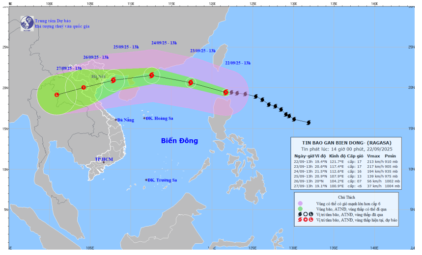
Current status of Super Typhoon Ragasa
At 1 PM today (September 22nd), the center of the super typhoon was located at approximately 19.4 degrees North latitude and 121.7 degrees East longitude, just above the sea north of Luzon Island (Philippines).
The strongest winds near the center of the storm reached level 17 (202-221 km/h), with gusts exceeding level 17. The storm is moving in a west-northwest direction at a speed of 20-25 km/h.
Predict path and intensity
Over the next 24 to 72 hours, the super typhoon will continuously move westward and gradually weaken, but will retain very strong intensity as it enters the Gulf of Tonkin.
Tonight and tomorrow night (September 23): The storm will enter the South China Sea, maintaining its strength at level 17.
September 24th: The storm was active in the northern South China Sea, approximately 230km from the Leizhou Peninsula (China). Wind speeds decreased to level 15-16, with gusts exceeding level 17.
September 25th: The storm entered the sea off the coast of provinces from Quang Ninh to Ninh Binh. Wind speeds decreased to level 12-13, with gusts up to level 16.
After September 25th, the storm is likely to move inland and weaken into a tropical depression.
Warning of hazardous effects
At sea:
Northern South China Sea area: Sea waves over 10.0m high, extremely rough seas. Winds near the storm's center are strong, reaching levels 15-17.
Gulf of Tonkin (from September 24th): Sea waves 5.0-7.0m high. Winds near the storm's center strong at level 11-13, gusting above level 16.
Warning:All vessels operating in the danger zone are at risk of being affected by strong gusts of wind, high waves, and tornadoes.
This is a very strong storm with complex developments. Information will be continuously updated by Nghe An Newspaper and Television.

