Storm No. 5 forecast to cause heavy to very heavy rain in Nghe An
(Baonghean.vn) - According to forecasts, the dangerous area in the East Sea in the next 24-48 hours will have strong winds from level 6, gusting from level 8 or higher. All ships operating in the dangerous area are at high risk of being affected by strong winds, big waves and whirlwinds.
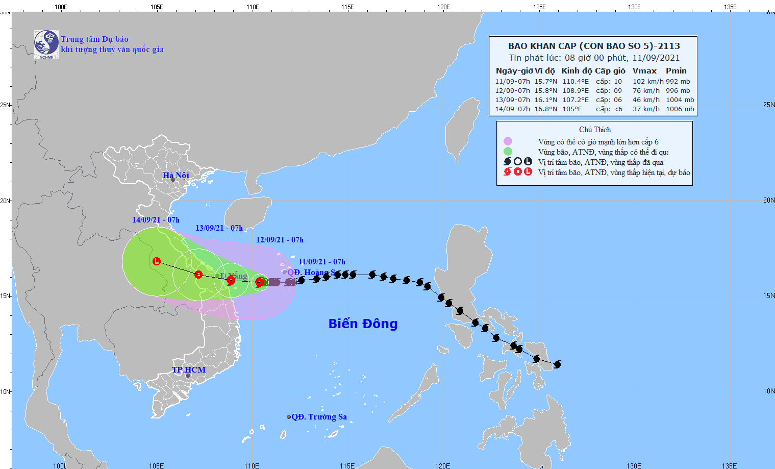
According toNorth Central Hydrometeorological Station:At 7:00 a.m. on September 11,The eye of the storm is located at about 15.7 degrees North latitude; 110.4 degrees East longitude, about 210 km east of the coast of Quang Tri - Quang Ngai. The strongest wind near the eye of the storm is level 9-10 (75 - 100 km/h), gusting to level 12. The radius of strong winds from level 6, gusting to level 8 or higher is about 160 km from the eye of the storm.
Forecast for the next 24 hours,The storm moved slowly to the West, about 5 km per hour. At 7:00 a.m. on September 12, the locationeye of the stormat about 15.8 degrees North latitude; 108.9 degrees East longitude, on the sea area from Quang Tri - Quang Nam. The strongest wind near the storm center is level 8-9 (60-90 km/h), gusting to level 11.
Dangerous areas in the East Sea in the next 24 hours (strong winds from level 6, gusts from level 8 or higher):From latitude 14.0 to 18.5 degrees North; west of longitude 112.0 degrees East. All vessels operating in the danger zone are at high risk of being affected by strong winds, large waves and whirlwinds.
 |
| Direction of storm No. 5. Photo: North Central Hydrometeorological Station |
Over the next 24 to 48 hours,The storm moved westward at 5-10 km per hour, weakening into a tropical depression and making landfall. At 7:00 a.m. on September 13, the center of the tropical depression was at about 16.1 degrees North latitude; 107.2 degrees East longitude, on the Vietnam - Laos border area. The strongest wind near the center of the tropical depression was level 6 (40-50 km/h), gusting to level 8.
Dangerous areas in the East Sea in the next 24 - 48 hours (strong winds from level 6, gusts from level 8 or higher):From latitude 14.5 to 18.5 degrees North; west of longitude 110.5 degrees East. All vessels operating in the danger zone are at high risk of being affected by strong winds, large waves and whirlwinds.
Over the next 48 to 72 hours,tropical depressionMoving in the West Northwest direction, traveling 10 km per hour and weakening into a low pressure area. At 07:00 on September 14, the center of the low pressure area was at about 16.8 degrees North latitude; 105.0 degrees East longitude, on the mainland of Central Laos. The strongest wind in the center of the low pressure area decreased to below level 6 (below 40 km/h).
 |
| Officers of Quynh Phuong Border Guard Station help vehicle owners anchor ships and boats at wharves and yards to avoid storm Conson. Photo courtesy of Hung Phong |
Warning of strong winds and high waves at sea:
Today and tonight (September 11), in the western sea area of the North and Central East Sea (including the sea area southwest of Hoang Sa archipelago), there will be storms, strong whirlwinds of level 8-9, near the storm center level 10, gusts of level 12; waves from 4.0-6.0m high; very rough seas.
In the sea area from Quang Tri to Quang Ngai (including Ly Son and Con Co island districts), the wind will gradually increase to level 6-7, then increase to level 8-9, gusting to level 11; waves will be 4.0-5.0m high; the sea will be very rough.
In the sea area of Nghe An - Ha Tinh, there are strong winds of level 6, gusts of level 8, waves from 2.0-3.0m high; rough sea.
On the sea of Nghe An: In the next 24 hours, the sea area of Nghe An province will have strong winds of level 6, gusting to level 7. Coastal waters (including Hon Ngu island) will have waves from 1.0-2.0m high, offshore (including Hon Mat island) from 2.0-3.0m; rough sea.
Heavy rain warning on land:
From September 12-14, in the provinces inNorth Central regionThere will be moderate to heavy rain, some places will have very heavy rain with rainfall in the North generally 50-100mm/period, some places over 100mm/period; in the South generally 100-200mm/period, some places over 200mm/period.


