Deep and widespread flooding continues in the North Central provinces.
(Baonghean.vn) - NThere is a high risk of landslides and riverbank subsidence on the rivers in the North Central region and widespread flooding continues in the North Central provinces. That is the assessment of theWeather expert - Mr. Nguyen Xuan Tien, Deputy Director of the North Central Region Hydrometeorological Station.
PV:Sir, could you please assess the current hydrometeorological situation and risks caused by weather?
Mr. Nguyen Xuan Tien:Currently, the flood on the lower reaches of the Ca River is on a slow rising trend; on other rivers in the North Central region, it is on a downtrend. Water levels at 07:00 on October 13 on the rivers are as follows:
- On Ma River at Ly Nhan: 8.27m, below level 1: 1.23m; at Giang: 4.10m, below level 1: 0.10m.
- On Buoi River at Kim Tan: 13.34m, above level BD3: 1.34m.
- On Ca River at Dua: 21.86m above level 1: 0.36m; at Do Luong: 15.01m above level 1: 0.50m; at Nam Dan: 6.37m above level 1: 0.97m.
It is forecasted that in the next 12 hours, the flood on Ca River in Nam Dan will peak at 6.45m, on BĐ1 1.05m and then fluctuate at the peak level; on rivers in the area, the trend will continue to decrease.
Water levels on rivers are likely to be as follows:
- Buoi River at Kim Tan at 12.6m (above BĐ3: 0.60m);
- Ma River at Ly Nhan is at 6.80m, below level 1: 2.70m; at Giang: 3.40, below level 1: 0.60m;
- Ca River at Dua is at 21.50 m, above level 1: 1.00 m; at Nam Dan is at 6.35 m, above level 1: 0.95 m.
 |
| A residential area in Hung Nhan commune, Hung Nguyen is surrounded by water. Photo: SN |
PV:What do you think about storm number 11 that is forming and gradually strengthening now?
Mr. Nguyen Xuan Tien:This morning, storm Khanun passed the North of Luzon Island (Philippines) and entered the East Sea, storm number 11.
At 7:00 a.m. on October 13, the center of the storm was at about 17.9 degrees North latitude; 120.1 degrees East longitude, in the sea northwest of Luzon Island (Philippines), about 880km East Northeast of the Paracel Islands. The strongest wind near the center of the storm was level 8 (60-75km/h), gusting to level 10.
It is forecasted that in the next 24 hours, the storm will move in a West-Southwest direction, traveling 10-15km per hour and intensifying. At 7:00 a.m. on October 14, the center of the storm will be at about 17.3 degrees North latitude; 117.3 degrees East longitude, about 540km East-Northeast of Hoang Sa archipelago. The strongest wind near the center of the storm is level 10 (90-100km/h), gusting to level 13.
Due to the influence of the storm, the eastern sea area of the North East Sea has stormy rain; strong winds of level 7-8, then increasing to level 9-10, gusting to level 13. The sea is very rough. The dangerous area in the next 24 hours (strong winds of level 6 or higher) is from latitude 14.0 to 21.0 degrees North; east of longitude 113.0 degrees East. Natural disaster risk level: level 3.
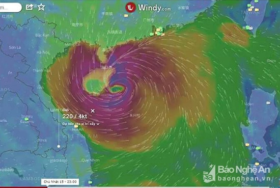 |
| Storm No. 11 named KHANUN is forming and gradually strengthening to level 12. Photo: VP |
It is forecasted that in the next 24 to 48 hours, the storm will move in a West-Northwest direction, traveling about 15km per hour and may continue to strengthen. At 7:00 a.m. on October 15, the center of the storm was at about 18.7 degrees North latitude; 113.8 degrees East longitude, about 220km northeast of Hoang Sa archipelago. The strongest wind near the center of the storm is level 12 (115-135km/h), gusting to level 15.
Forecast in the next 48 to 72 hours, the storm moves in the West Northwest direction, about 20km per hour.
PV:So what is the weather situation in the North Central region today and tonight (October 13)?
Mr. Nguyen Xuan Tien:Due to the influence of the continental cold high pressure tongue, combined with the northern edge of the Tropical Convergence Zone with an axis at about 13 - 15 degrees north latitude, the sky in the area is cloudy. There is rain, scattered showers and thunderstorms. East to Northeast wind level 3, coastal areas have places level 4.
Warning: High risk of landslides and riverbank subsidence on rivers in the North Central region and widespread flooding continues in the North Central provinces.
PV:Is this an unusual weather pattern? Has this happened in the past?
Mr. Nguyen Xuan Tien:September and October are the main flood season in the North Central region, so this flood in Nghe An is not unusual. However, it is rare for this rain to spread to the North and Northwest. In the past, there have been major floods during this period on rivers in Nghe An such as in 1988, 2010, 2013.
PV:What is your forecast for weather phenomena in the coming time?
Climate change has had, is having and will have many major impacts on Vietnam in general and Nghe An in particular. Climate change will increase the number of storms of high intensity, increase other hydrometeorological phenomena such as storms, tornadoes, hail, heavy rain, floods, flash floods, inundation, drought, severe cold...
Thank you!
Viet Phuong
| RELATED NEWS |
|---|


.jpg "Thời tiết Nghệ An ngày 25/9: Có mưa vừa đến mưa to, có nơi mưa rất to và dông")


