Super typhoon Ragasa, with gusts exceeding level 17, is entering the East Sea, and heavy rain is forecast across a wide area of Nghe An province.
According to the National Center for Hydro-Meteorological Forecasting, at 5 PM on September 22nd, Typhoon Ragasa was located approximately 120km north of Luzon Island (Philippines), maintaining its intensity at level 17 (202-221 km/h), with gusts exceeding level 17, and was still moving in a west-northwest direction at a speed of 20-25 km/h as it entered the East Sea.
According to the National Center for Meteorological and Hydrological Forecasting, at 5 PM on September 22nd, Typhoon Ragasa was still moving in a west-northwest direction at a speed of 20-25 km/h.
Accordingly, the forecast indicates that in the northern part of the North East Sea, winds will gradually strengthen to level 8-9, then increase to level 10-14, reaching level 15-17 in the area near the center of the super typhoon, with gusts exceeding level 17, and sea waves higher than 10.0m; the sea will be extremely rough.
From September 24th, the forecast indicates that winds in the Gulf of Tonkin will gradually strengthen to level 6-7, then increase to level 8-10, reaching level 11-12 in areas near the storm's center, with gusts up to level 15, and sea waves reaching 5.0-7.0m; the sea will be extremely rough. Vessels operating in the aforementioned dangerous areas are likely to be affected by thunderstorms, tornadoes, very strong winds, and very large waves.
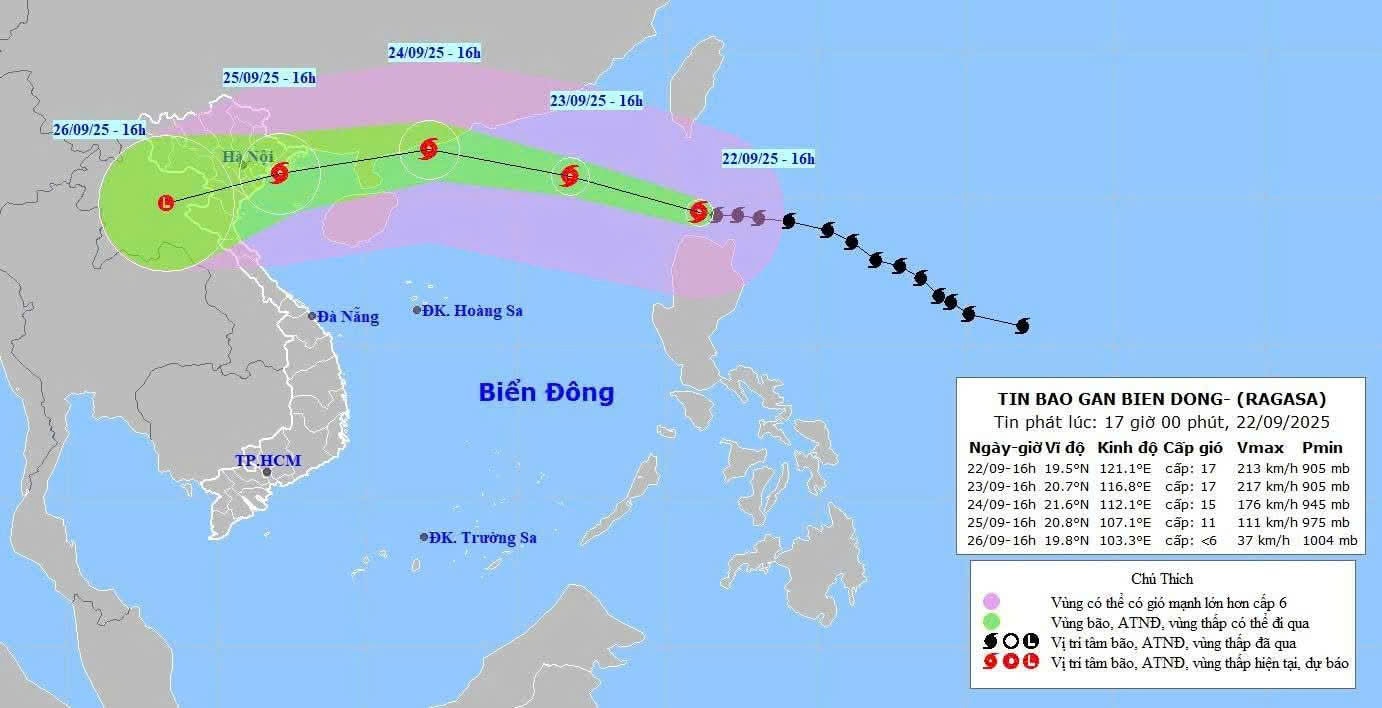
In the northern part of the South China Sea, winds will gradually strengthen to level 8-9, then increase to level 10-14, reaching level 15-17 near the center of the super typhoon, with gusts exceeding level 17, and sea waves over 10.0m high; the sea will be extremely rough.
From September 24th, strong winds in the Gulf of Tonkin will gradually increase to level 6-7, then to level 8-10, reaching level 11-12 in areas near the storm's center, with gusts up to level 15, and sea waves reaching 5.0-7.0m; the sea will be extremely rough. Vessels operating in the aforementioned dangerous areas are likely to be affected by thunderstorms, tornadoes, very strong winds, and very large waves.
Over the next 72 to 96 hours, the storm will move in a west-southwest direction at approximately 20 km per hour, continuing to weaken in intensity.
In Nghe An province, according to the Nghe An Meteorological and Hydrological Station, the tropical convergence zone connected to Typhoon Ragasa is forecast to gradually shift northward from the night of September 22nd to 24th. On September 25th and 26th, under the influence of the southern circulation of Typhoon Ragasa, combined with a weak strengthening of the continental high-pressure system, widespread rain is expected.
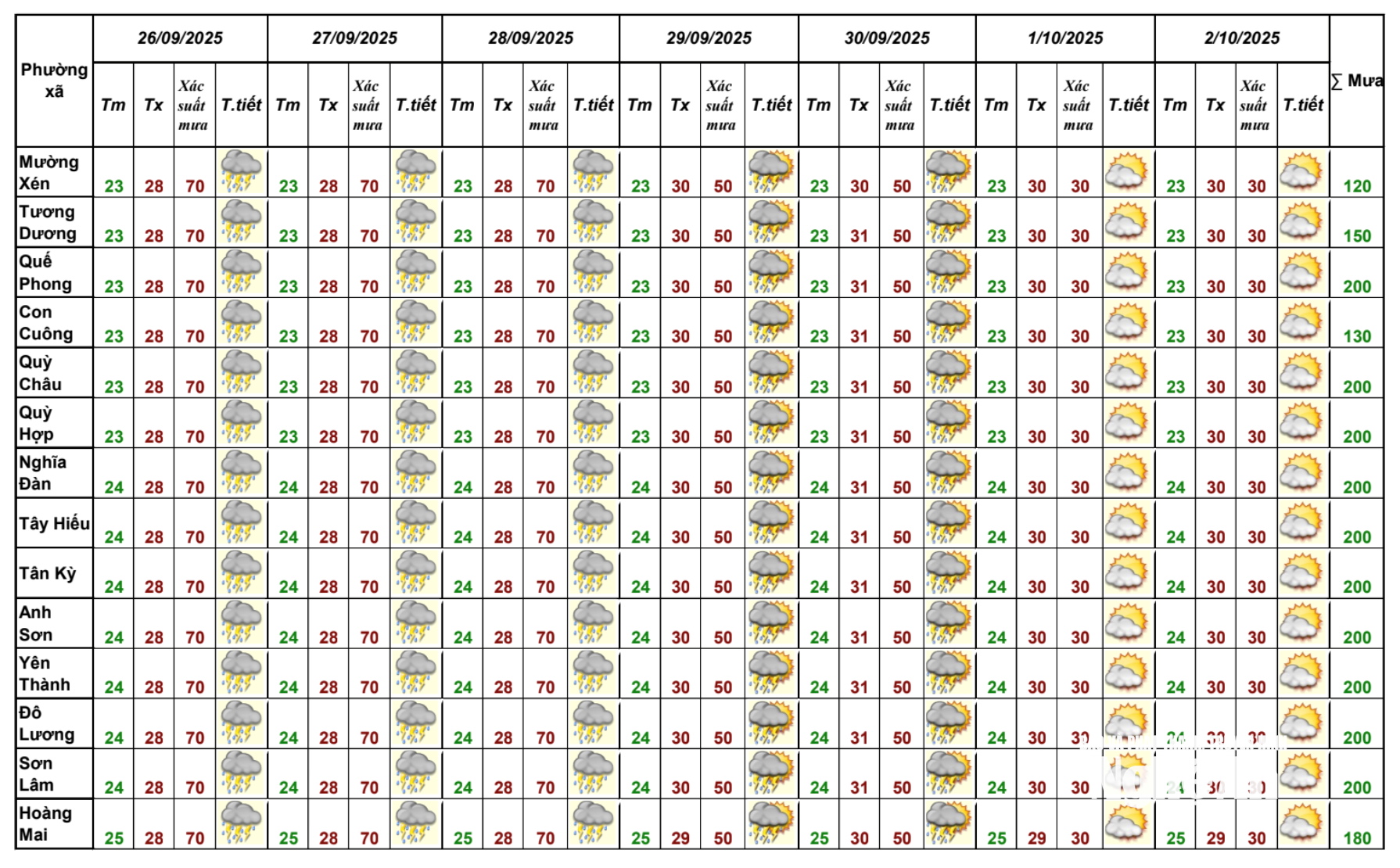
From September 27th to October 2nd, a tropical convergence zone is likely to re-form in Nghe An province, with its axis passing through the South Central coastal region. At higher altitudes, the subtropical high-pressure system is strongly encroaching westward; wind convergence is tending to become increasingly active. Therefore, there is a potential impact on the environment, living conditions, infrastructure, and socio-economic activities: Thunderstorms accompanied by tornadoes, lightning, and strong gusts of wind could affect agricultural production, cause trees to fall, damage houses, transportation infrastructure, and other facilities.
Heavy rainfall and localized heavy rain are likely to cause flooding in low-lying areas; flash floods on small rivers and streams, and landslides on slopes.

