Super typhoon Yutu with wind gusts of level 15 causes rain and rough seas
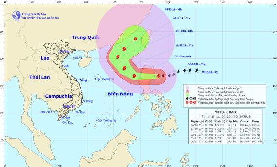
(Baonghean.vn) - According to the National Center for Hydro-Meteorological Forecasting, at 1:00 a.m. on October 30, the center of the storm was at about 16.7 degrees North latitude; 123.2 degrees East longitude, right on the sea east of Luzon Island (Philippines).
The strongest wind near the storm center is level 14 (150-165km/h).level 16. The range of strong winds of level 6, gusting to level 8 or higher is about 320km from the center of the storm; The range of strong winds of level 10 or higher is about 120km from the center of the storm.
 |
| Location and path of the storm. Photo: National Center for Hydro-Meteorological Forecasting |
Forecast for the next 24 hours,The storm is moving west at a speed of 15-20km per hour. At 1:00 a.m. on October 31, the center of the storm was at approximately 16.8 degrees North latitude; 118.8 degrees East longitude, approximately 700km east of the Paracel Islands.
The strongest wind near the storm center is level 12 (115-135km/hour).level 1 shock5. The range of strong winds of level 6, gusting to level 8 or higher is about 270km from the center of the storm; The range of strong winds of level 10 or higher is about 90km from the center of the storm.
Due to the influence of the storm, in the Northeast Sea of the East Sea from this morning (October 30) there will be stormy rain, strong winds of level 7-9, from this afternoon gradually increasing to level 10-11, near the eye of the storm level 12-13,level 15; rough seas.
Dangerous areas in the East Sea in the next 24 hours (strong wind level 6 or higher): North of latitude 14.0 degrees North; East of longitude 115.5 degrees East.Disaster risk levelliveNortheast East Sea area: Level 3.
Over the next 24 to 48 hours,The storm is moving northwest at about 15km per hour. At 1:00 a.m. on November 1, the center of the storm was at about 18.2 degrees North latitude; 117.0 degrees East longitude, about 450km East Northeast of the Hoang Sa archipelago. The strongest wind near the center of the storm is level 11 (100-115km/hour).jerky14.
Over the next 48 to 72 hours,The storm is moving in a northwesterly direction, traveling about 15km per hour. At 1:00 a.m. on November 2, the center of the storm was at about 20.3 degrees North latitude; 115.8 degrees East longitude, about 460km North-Northeast of the Hoang Sa archipelago. The strongest wind near the center of the storm is level 10 (90-100km/hour).level 13.
 |
| Temperature on October 30 in regions across the country. Photo: news.zing.vn |


 với tinh thần quyết liệt nhất")

