The underground river beneath the Bản Mồng irrigation dam is a karst cave.
(Baonghean.vn) - The unusual water flow in the Chau Binh auxiliary dam drainage canal is not an underground river but a karst cave phenomenon, which was detected previously and is under the control of the authorities.
On September 8th, Nghe An Online Newspaper published an article."Underground river discovered beneath the largest irrigation dam in North Central Vietnam"The Chau Binh auxiliary dam and drainage canal project, part of the larger Ban Mong irrigation and hydropower project, is showing many unusual signs. Locals believe there is an underground river and strong currents. Nghe An Newspaper contacted relevant authorities to clarify this issue.
 |
| Mr. Dinh Tri Lam, Deputy Head of the Ban Mong Reservoir Project Management Board. |
Mr. Dinh Tri Lam, Deputy Head of the Ban Mong Reservoir Project Management Board, said: The Ban Mong Reservoir is a key irrigation project of the province, built in two communes: Chau Binh (Quy Chau) and Yen Hop (Quy Hop), with a total investment of nearly 4,500 billion VND. This project provides irrigation water for 18,871 hectares along the Hieu River, including 2,713 hectares of gravity irrigation, and supplies water to the Ca River during the dry season at a rate of approximately 22 m³/s.
Explaining the issue of water flowing through the drainage ditch, Mr. Dinh Tri Lam stated: During the survey and design process, several locations with karst caves were discovered. According to the design, water from the drainage canal should flow into the Hieu River; however, the water flows through the karst caves instead of into the Hieu River.
This is just a geological phenomenon that does not affect the construction; we anticipated and prepared for these events during the survey and design process.
Furthermore, since this is a drainage canal, there's no need to fix the karst caves. If the Chau Binh drainage canal is later dammed to serve irrigation purposes, the leaks leading down to the karst caves can be filled. The claim that there's an underground river beneath is unfounded and requires the involvement of scientists.
Mr. Nguyen Nhu Dung, a technical officer of the Infrastructure Design and Consulting Joint Stock Company - the project manager for the Ban Mong irrigation project, added: During the geological survey for the design of the Chau Binh drainage canal, no karst caves were detected because the boreholes were not deep enough (according to the design, they were only drilled 2-3 meters deeper than the canal bed). 40 boreholes were drilled along the 8.1 km Chau Binh drainage canal.
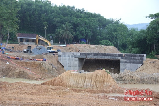 |
| Three karst cave locations have been discovered at three bridge construction sites on the Chau Binh drainage canal. |
Subsequently, during the geological survey for the design of six bridges over the Chau Binh drainage canal, the consulting unit discovered three locations with karst caves, two of which were dry and one contained water. To address this situation, the following solutions are necessary: Firstly, the inlet of the karst caves is now known to be the water outlets. The problem is to find the cave entrance. In reality, finding the entrance to a karst cave is very difficult; the cave may meander, discharging water into a stream or the Hieu River, or it may run back into a cave in a mountain and then flow into the river. Therefore, deeper exploratory drilling is needed to conduct a comprehensive assessment and locate the karst cave's outlet for remediation.
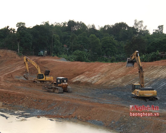 |
| Some locations in the Chau Binh drainage canal have revealed sand caves. |
Mr. Nguyen Quang Hoa, Director of the Center for Application of Science and Technology in Irrigation in Nghe An, shared: Before constructing the Ban Mong irrigation project, the Ministry of Agriculture assigned the University of Irrigation to be responsible for surveying and assessing the geological conditions of the project's routes, paying particular attention to karst caves, given the mountainous terrain. Any karst caves discovered during the construction of this project are under the control of the relevant authorities.
Mr. Hoang Nghia Hieu, Director of the Department of Agriculture and Rural Development, said: "Regarding the construction of the Chau Binh drainage canal, we are aware that the geological strata contain localized karst caves. Therefore, during the construction of the bridges, including three bridges located in karst cave areas, we instructed the construction unit to drive concrete piles to ensure the quality of the project. Currently, we are continuing to survey and inspect to find safe solutions for this project."
| Karst CavelThis is a characteristic weathering phenomenon of limestone mountainous areas eroded by flowing water. The erosion is not due to mechanical forces, but mainly due to carbon dioxide (CO2) in the air dissolving in water, combined with positive hydrogen ions (H+) to form carbonic acid. Carbonic acid is the main culprit in the erosion of limestone. The natural products of karst weathering are caves with stalactites, stalagmites, underground rivers and streams, etc. |
Van Truong
| RELATED NEWS |
|---|

