Latest information on super typhoon Mangkhut and storm No. 5 (Barijat) near the coast
(Baonghean.vn) - It is forecasted that in the next 24 hours, storm No. 5 will move westward, traveling about 15-20km per hour and is likely to strengthen. Meanwhile, super typhoon Mangkhut will move toward the North East Sea in the next 3 days.
This morning, super typhoon Mangkhut in the Northwest Pacific Ocean maintained its strongest wind near the center of the storm at level 16 (185-200km/h). Super typhoon Mangkhut will move towards the North East Sea in the next 3 days.
According to the National Center for Hydro-Meteorological Forecasting,at 4:00 a.m. on September 12, the center of the storm is located at about 20.6 degrees North latitude; 116.1 degrees East longitude, about 570km East Northeast of Hainan Island (China). The strongest wind near the center of the storm is level 8 (60-75km/hour),level 10. The range of strong winds of level 6, gusting to level 8 or higher is about 80km from the center of the storm.
Forecast for the next 24 hours,The storm is moving westward at a speed of 15-20km per hour and is likely to strengthen. At 4am on September 13, the storm's center was at approximately 20.6 degrees North latitude; 112.5 degrees East longitude, approximately 180km East Northeast of Hainan Island. The strongest wind near the storm's center is at level 8-9 (60-90km/hour).level 11The range of strong winds of level 6, gusting to level 8 or higher is about 110km from the center of the storm.
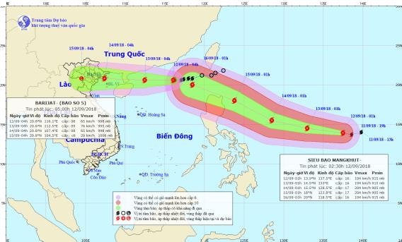 |
| Storm path and location. Photo: National Center for Hydro-Meteorological Forecasting |
Due to the influence of the storm, the northern sea area of the North East Sea has stormy rain, strong winds of level 6-7, the area near the storm's eye has level 8-9.level 11; rough seas.
Dangerous areas in the East Sea in the next 24 hours (strong wind level 6 or higher): North of latitude 18.5 degrees North; East of longitude 111.5 degrees East.
Over the next 24 to 48 hours,The storm is moving westward at a speed of about 20km per hour. At 4am on September 14, the storm's eye was at about 20.8 degrees North latitude; 107.4 degrees East longitude, right on the coast of the provinces from Quang Ninh to Nam Dinh. The strongest wind near the storm's eye is level 8 (60-75km/hour).level 10. The range of strong winds of level 6, gusting to level 8 or higher is about 80km from the center of the storm.
Over the next 48 to 60 hours,The storm weakened into a tropical depression and moved into the provinces from Quang Ninh to Nam Dinh, traveling about 25km per hour. After that, the tropical depression continued to weaken rapidly into a low pressure area on the Vietnam-Laos border area.
At 4:00 p.m. on September 14, the center of the low pressure area was at about 20.8 degrees North latitude; 104.5 degrees East longitude. The strongest wind near the center of the low pressure area decreased to below level 6 (below 40km/h).Disaster risk level: level 3.


