Storm News Near Shore: Storm No. 2
(Baonghean.vn) - Due to the influence of storm No. 2, tonight (June 5) and tomorrow, the North Central region will have moderate to heavy rain and thunderstorms. During thunderstorms, beware of tornadoes and strong gusts of wind.
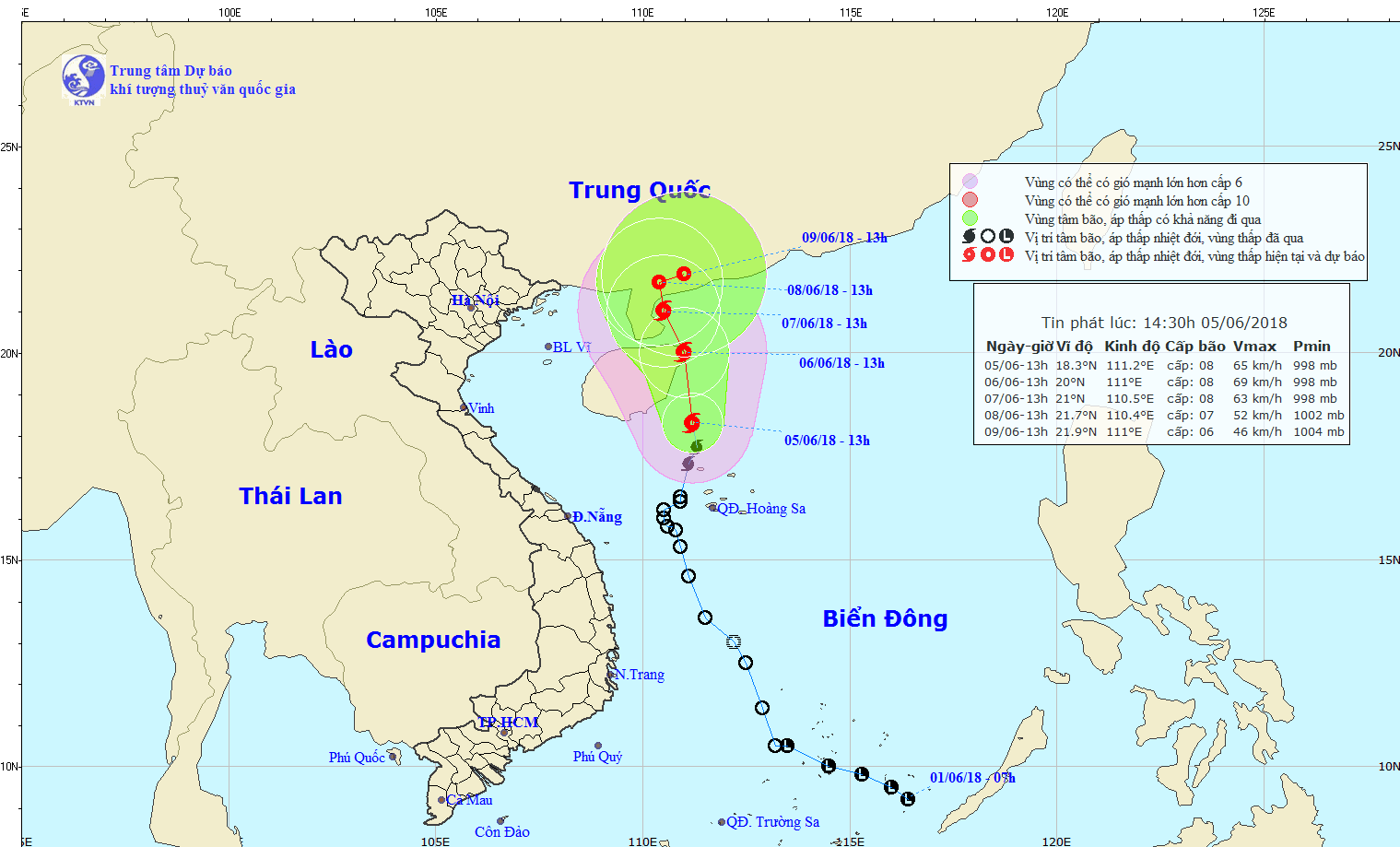
According to the latest news received from the North Central Hydrometeorological Station, at 1:00 p.m. on June 5, the center of the storm is located at about 18.3 degrees North latitude; 111.2 degrees East longitude, about 120km southeast of Hainan Island. The strongest wind near the center of the storm is level 8 (60-75km/hour),level 10.
 |
| Path of storm No. 2. Photo: Provided by the Central Highlands Hydrometeorological Station. |
Forecast for the next 24 hoursThe storm is moving mainly in a northerly direction, traveling 5-10km per hour. At 1pm on June 6, the storm's eye was at about 20.0 degrees North latitude; 111.0 degrees East longitude, right on the sea northeast of Hainan Island. The strongest wind near the storm's eye is level 8 (60-75km/h).level 11. The range of strong winds of level 6, gusting to level 8 or higher is about 100km from the center of the storm.
Due to the influence of the storm, in the West of the North East Sea (including the waters of Hoang Sa archipelago), there will be strong thunderstorms; strong winds level 6-7, near the storm center level 8,level 11; very rough seas. Offshore waters of Central Vietnam and the Gulf of Tonkin have showers and thunderstorms with tornadoes and strong gusts of wind.
Dangerous areas in the East Sea in the next 24 hours: (strong wind level 6 or higher) from latitude 16.5 to 21.0 degrees North; from longitude 108.0 to 113.0 degrees East.
Disaster risk level: level 3.
In the next 24 to 48 hours, the storm is moving in the North-Northwest direction, traveling 5km per hour. At 13:00 on June 7, the center of the storm is at about 21.0 degrees North latitude, 110.5 degrees East longitude, in the area east of Leizhou peninsula (China). The strongest wind near the center of the storm is level 8 (60-75km/hour),level 10. The range of strong winds of level 6, gusting to level 8 or higher is about 80km from the center of the storm.
Disaster risk level: level 3.
In the next 48 to 72 hours, the storm moved mainly to the North, traveling about 5km per hour and gradually weakened into a tropical depression. At 13:00 on June 8, the center of the tropical depression was at about 21.7 degrees North latitude, 110.4 degrees East longitude. The strongest wind near the center of the tropical depression was level 7 (50 - 60km/hour),level 9.
In the next 72 to 96 hours, the tropical depression moved northeast and weakened further.
Weather in the North Central region(Night of June 5th to June 6th):
At sea:There is moderate to heavy rain and thunderstorms (During thunderstorms, watch out for tornadoes and strong winds.). Coastal waters have strong winds of level 4 - level 5; Offshore waters have strong winds of level 6 - level 7, gusting above level 7. Common wave height in coastal waters: 0.5 - 1.5m and offshore waters: 1.5 - 2.5m. Rough seas.Level 3 natural disaster risk.
On land: Clouds change to cloudy, rain, showers at night and early morning, some places have moderate to heavy rain and scattered thunderstorms. During the day, less rain. Northeast to North wind level 3.


.jpg)
