URGENT STORM NEWS: Storm No. 10 with level 15 gusts, making landfall in Nghe An - Quang Tri, warning of causing extremely dangerous natural disaster complex
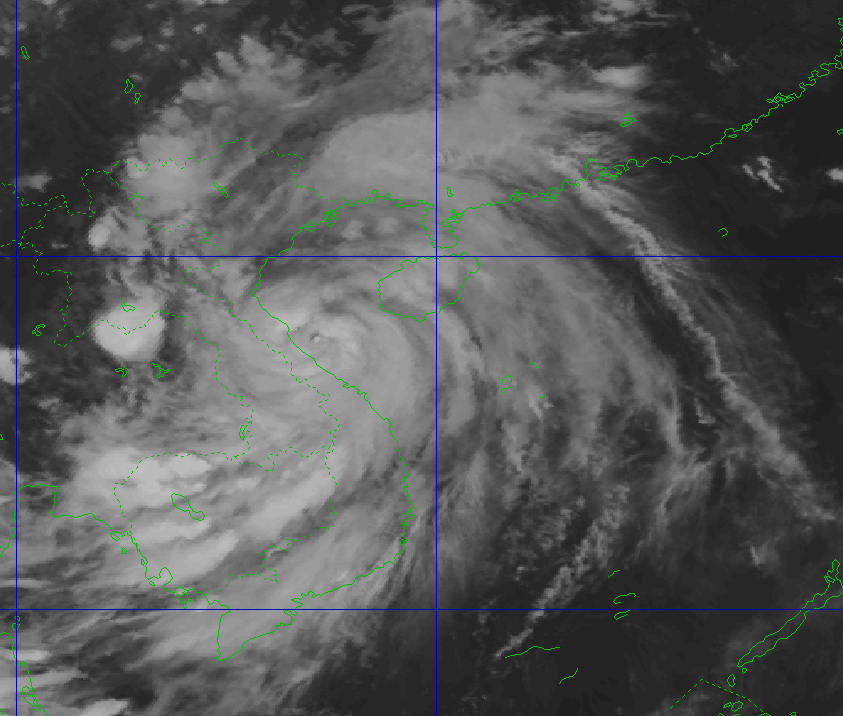
The center of storm No. 10 is located on the coastal area of Nghe An - Northern Quang Tri with extremely strong winds of level 12, gusts of level 15. This is a fast-moving storm, strong intensity, wide range of influence, warning of causing extremely dangerous natural disasters such as strong winds, big waves, storm surge, coastal flooding and widespread rain and flash floods.
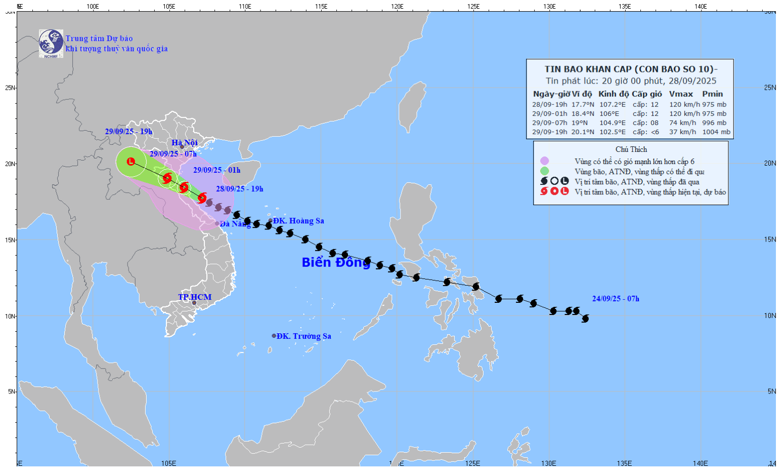
Current location and intensity of the storm
According to the bulletin issued at 8:00 p.m. on September 28 from the National Center for Hydro-Meteorological Forecasting, the center of storm No. 10 is at about 17.7 degrees North latitude; 107.0 degrees East longitude, on the coastal area of Nghe An - North Quang Tri.
Storm No. 10 currently has the strongest wind near the storm center reaching level 12 (118-133km/h), gusting up to level 15. The storm is moving in the West Northwest direction, at a speed of about 20-25km/h.
This storm is considered very dangerous due to its fast speed, strong intensity, and ability to cause combined impacts of many types of natural disasters: strong winds, big waves, storm surge, heavy rain, floods, flash floods, landslides and coastal flooding.
As of 7 p.m. on September 28, many measuring stations recorded strong winds: Level 10, gusting to level 11 at Con Co (Quang Tri); level 8, gusting to level 9 at Bach Long Vi (Hai Phong); level 7, gusting to level 9 at Co To (Quang Ninh). On the mainland, coastal provinces from Quang Ninh to North Quang Tri had strong winds of level 6-8, gusting to level 9-10.
Forecasting developments and emergency risks
At sea:
The sea area from Thanh Hoa to Quang Tri has strong winds of level 8-10, near the storm center reaching level 11-12, gusting to level 15. Waves are 6.0-8.0m high, the sea is very rough. Warning of extreme danger for large vessels, there is a possibility of sinking the ship.
The Northern Gulf of Tonkin has strong winds of level 6-9, gusts of level 11, waves 3.0-5.0m high, very rough seas.
Storm surge and coastal flooding risk:
Coastal areas and islands from Hung Yen to Ha Tinh have storm surges of 0.5-1.5m. Thanh Hoa and Nghe An in particular have surges of 1.0-1.5m.
High flood warning in the early morning of September 29 in low-lying areas, coastal roads, and river estuaries due to a combination of rising sea levels, big waves, and storms.
On land:
From Thanh Hoa to Northern Quang Tri: Strong winds level 7-9, near the storm center level 10-12, gusting to level 14. Wind force is capable of knocking down trees, houses, and electric poles, causing very heavy damage.
From Quang Ninh to Ninh Binh: Strong wind level 6-7, gust level 8-10.
Heavy rain and flooding forecast
Storm No. 10 will cause widespread heavy rain:
From the night of September 28 to September 30: The Northern Delta region, Phu Tho, Southern Son La, Lao Cai and the provinces from Thanh Hoa to Northern Quang Tri will have heavy to very heavy rain with a total rainfall of 200-350mm, locally over 500mm.
Warning of risk of heavy rain (>200mm/3h).
Other places in the North also have heavy rain, some places very heavy with total rainfall of 100-250mm, locally over 400mm.
Weakening forecast
7am September 29: The storm makes landfall in Nghe An-Ha Tinh provinces, weakening to level 8-9, gusting to level 11.
7:00 p.m. September 29: The storm gradually weakened into a tropical depression in the Upper Laos region.
URGENT NOTE:
The weather at sea and in coastal areas during the storm is extremely dangerous, unsafe for any vehicles or structures operating in the danger zone such as cruise ships, transport ships, aquaculture cages, dykes, embankments, coastal routes. Vehicles are at high risk of capsize, destruction or flooding due to strong winds, big waves and rising sea levels.


