URGENT STORM NEWS (Storm No. 10): At 4:00 a.m. on September 27, the center of the storm was about 580km from Hoang Sa special zone.
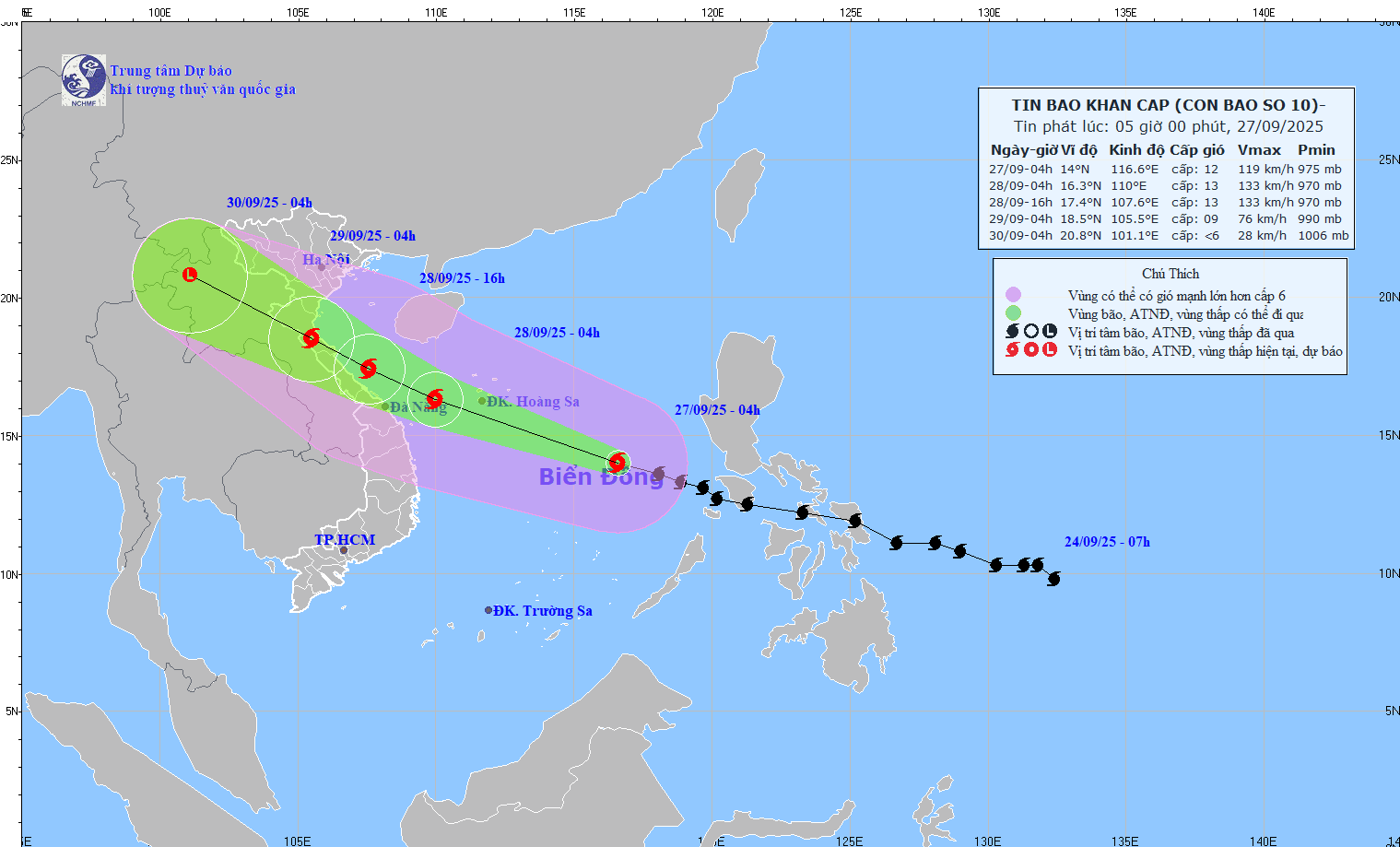
At 4:00 a.m. on September 27, the center of the storm was at about 14.0°N; 116.6°E, about 580km East Southeast of Hoang Sa special zone. The strongest wind near the center of the storm was level 11-12 (103-133km/h), gusting to level 15. Moving in the West Northwest direction at a speed of 35-40km/h.
This is a very fast moving storm (nearly twice the average speed), strong intensity, wide range of influence, can cause combined impacts: strong winds, heavy rain, floods, flash floods, landslides and coastal flooding.
Storm forecast (next 24–72 hours):
04:00 September 28:
• Location: 16.3°N – 110.0°E, on the sea west of Hoang Sa special zone, about 180km east of Da Nang.
• Movement: West Northwest, 30-35km/h, with the possibility of strengthening.
• Intensity: Level 12-13, jerk level 16.
• Danger zone: 11.5°N–18.5°N; east of longitude 108.0°E.
• Disaster risk level: Level 3.
• Affected areas: North and Central East Sea (including Hoang Sa); sea area from Ha Tinh to Quang Ngai.
4:00 p.m. September 28:
• Location: 17.4°N – 107.6°E, on the sea from Ha Tinh – Thua Thien Hue, about 160km East Southeast of North Quang Tri.
• Movement: West Northwest, ~25km/h.
• Intensity: Level 12-13, jerk level 16.
• Danger zone: North of latitude 13.5°N; West of longitude 113.0°E.
• Disaster risk level: Level 3.
• Affected areas: the northwest sea of the East Sea (including Hoang Sa), the northwest of the central East Sea; from Thanh Hoa to Quang Ngai (Hon Ngu, Con Co, Ly Son) and the northern Gulf of Tonkin (Bach Long Vy, Van Don, Co To, Cat Hai, Hon Dau); mainland from Ninh Binh to Thua Thien Hue.
04:00 September 29:
• Location: 18.5°N – 105.5°E, on land from Nghe An to North Quang Tri.
• Movement: West Northwest, 20-25km/h.
• Intensity: Level 8-9, jerk level 11.
• Danger zone: North of latitude 15.0°N; West of longitude 110.5°E.
• Disaster risk level: Level 3.
• Affected areas: the Northwestern sea of the East Sea (including Hoang Sa), from Thanh Hoa to Quang Ngai (Hon Ngu, Con Co, Ly Son), Northern Gulf of Tonkin (Bach Long Vy, Van Don, Co To, Cat Hai, Hon Dau); mainland from Ninh Binh to Thua Thien Hue.
04:00 September 30:
• Location: 20.8°N – 101.1°E, in the Upper Laos region.
• Moving: West Northwest, 20-25km/h, weakening into a low pressure area.
• Intensity: below level 6.
• Danger zone: North of latitude 17.0°N; West of longitude 108.0°E.
• Disaster risk level: Level 3.
• Affected areas: sea areas from Thanh Hoa to North Quang Tri (Hon Ngu, Con Co) and North Gulf of Tonkin (Bach Long Vy, Van Don, Co To, Cat Hai, Hon Dau); mainland from Ninh Binh to North Quang Tri.
Forecasting the impact of storms:
At sea:
• North and Central East Sea (including Hoang Sa): wind level 8-9, near storm center 10-13, gust 16; waves 6.0-10.0m; rough sea.
• From the evening of September 27, Thanh Hoa - Quang Ngai sea area (Hon Ngu, Con Co, Ly Son): wind increased to 6-7, gusts 8-9; near the morning of September 28 increased to 8-9, near the storm center 10-13, gusts 16; waves 5.0-7.0m; rough sea.
• From early morning of September 28, Northern Gulf of Tonkin (Bach Long Vy, Van Don, Co To, Cat Hai, Hon Dau): wind increases to 6-7, then strong 8-9, gust 11; waves 3.0-5.0m; very rough seas.
• Storm surge: 1.0–2.0m along the coast from Ninh Binh – Ha Tinh, 1.5–2.0m in Thanh Hoa – Nghe An; risk of flooding dikes, coastal roads, and destruction of aquaculture.
On land:
• From the afternoon of September 28, Thanh Hoa - Northern Quang Tri wind 6-7, increasing to 8-9, near the storm center 10-12, gust 14 (dangerous, can cause trees, electric poles, houses to fall).
• Quang Ninh – Ninh Binh and South Quang Tri – Thua Thien Hue: wind 6-7, gust 8-9.
Heavy rain:
• From September 28–30: Northern region and Thanh Hoa – Hue rain 100–300mm, locally >400mm.
• Northern Delta and Thanh Hoa - Ha Tinh: 200–400mm, locally >600mm.


