Urgent storm news, storm number 7
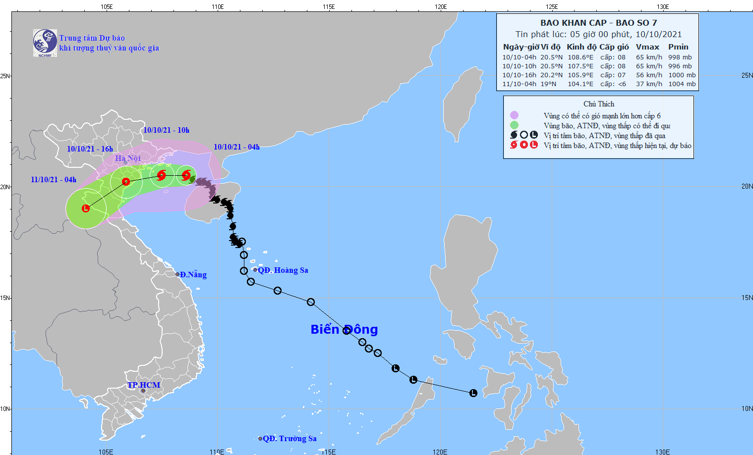
At 4:00 a.m. on October 10, the center of storm No. 7 was at about 20.5 degrees North latitude; 108.6 degrees East longitude, about 100km northeast of Bach Long Vi island. The strongest wind near the center of the storm was level 8.
According to the National Center for Hydro-Meteorological Forecasting, at 4:00 a.m. on October 10, the locationeye of the stormNo. 7 is located at about 20.5 degrees North latitude; 108.6 degrees East longitude, about 100km northeast of Bach Long Vi island. The strongest wind near the storm center is level 8 (60-75km/hour),level 10.Radius of strong winds from level 6, gusting from level 8 about 120km from the center of the storm.
 |
| Direction of movement of storm number 7. |
Forecast for the next 6 hours,The storm is moving mainly in a westerly direction, traveling about 15km per hour. At 10:00 on October 10, the center of the storm was at about 20.5 degrees North latitude; 107.5 degrees East longitude, about 100km from Hai Phong, about 130km from Nam Dinh, and about 180km from Thanh Hoa. The strongest wind near the center of the storm is level 8 (60-75km/hour),level 10.
Forecast for the next 12-24 hours,The tropical depression moved mainly in the West-Southwest direction, traveling about 20km per hour, moving deep inland and weakening into a low-pressure area over Central Laos. At 4:00 a.m. on October 11, the center of the low-pressure area was at about 19.0 degrees North latitude; 104.1 degrees East longitude, over Central Laos. The strongest wind in the center of the low-pressure area decreased to below level 6 (below 40km/hour).
Dangerous areas in the East Sea in the next 24 hours(strong wind level 6 or higher, gusting from level 8 or higher): North of latitude 18.5 degrees North; West of longitude 110.0 degrees East. All vessels operating in the danger zone are at high risk of being affected by strong winds and large waves.Disaster risk warning level: level 3.
Warning of strong winds and high waves at sea:
Due to the combined influence of the circulation of storm No. 7 with the strengthening cold air, in the Gulf of Tonkin (including Bach Long Vi and Co To island districts), there are strong winds of level 6-7, near the storm center, strong winds of level 8, gusting to level 10; waves from 3.0-4.0m high, very rough seas.
Strong Wind Warning on Land:
Today (October 10), coastal areas from Quang Ninh toNghe AnStrong winds level 6-7, in the North some places level 8, gusting to level 10.
From this afternoon to tonight (October 10), in Lang Son, Bac Giang, Bac Ninh, Hai Duong, Hung Yen, Hanoi there will be strong gusts of wind level 6-7.
Heavy Rain Warning:
- From today (October 10) to October 11, in the Northeast, there will be heavy to very heavy rain, with total rainfall of 150-200mm, in some places over 250mm; in the Northwest, there will be heavy rain, with total rainfall of 50-100mm, in some places over 150mm;
- From today (October 10) to October 12, in the North Central region, there will be heavy to very heavy rain, with total rainfall ranging from 100-250mm, with some places over 250mm.
Warning of high risk of flash floods,landslidein mountainous areas and localized flooding in low-lying areas and riverside areas.
Warning:Currently, in the East Sea of the Philippines, a storm with the international name KOMPASU is active. At 4:00 a.m. this morning (October 10), storm KOMPASU was located at about 15.1 degrees North latitude; 130.1 degrees East longitude with a strong intensity of level 8-9, gusting to level 11. It is forecasted that around the night of October 11 to the morning of October 12, storm KOMPASU is likely to enter the East Sea./.


