Live storm number 13 tonight, November 6: Has made landfall in Dak Lak - Gia Lai provinces
Live storm No. 13: At 8:00 p.m. tonight, the center of storm No. 13 will be at about 13.8 degrees North latitude; 109.0 degrees East longitude, on the mainland of Dak Lak - Gia Lai provinces. The strongest wind is level 12 (118-133km/h), gusting to level 15.
BREAKING NEWS ABOUT STORM NO. 13 (at 8:00 p.m. on November 6)
(Source: National Center for Hydro-Meteorological Forecasting)
Storm center location: About 13.8 degrees North latitude; 109.0 degrees East longitude, on the mainland of Dak Lak - Gia Lai provinces.
Strongest wind: Level 12 (118-133km/h), gust level 15.
Forecast: In the next 3 hours, the storm will move mainly in the West Northwest direction, at a speed of about 25-30km/h.
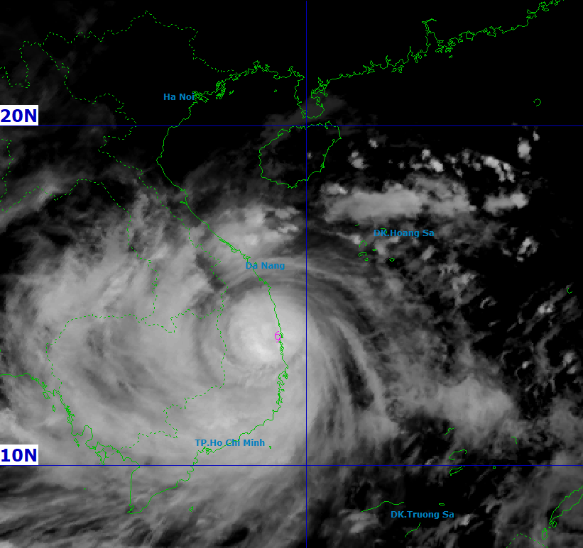
According to the National Center for Hydro-Meteorological Forecasting, at 8:00 p.m. on November 6, the center of storm No. 13 was at about 13.8 degrees North latitude and 109.0 degrees East longitude, located on the mainland of Dak Lak - Gia Lai provinces.
Storm No. 13 has the strongest wind speed of level 12 (118-133 km/h), gusting to level 15, causing serious impacts on the Central and Central Highlands regions. The strong wind range is widespread, causing many localities to record extremely strong gusts of wind and prolonged heavy rain.
Due to the impact of storm No. 13, strong winds were recorded at many meteorological stations: Ly Son (Quang Ngai) had winds of level 8, gusts of level 10; Hoi An (Da Nang) had winds of level 8, gusts of level 10; Dung Quat (Quang Ngai) had winds of level 8, gusts of level 9.
In the Central Highlands, stations such as Hoa Nhon Dong (Gia Lai) have wind level 8, gusts level 10; Phu Cat (Gia Lai) have wind level 9, gusts level 13; An Nhon (Gia Lai) have wind level 10, gusts level 14.
Several other places such as Hoai Nhon, Quy Nhon, Canh Thuan and Son Hoa were also heavily affected by storm No. 13, with winds ranging from level 7 to level 9, gusting to level 10-11. Rainfall recorded at stations from Thua Thien Hue to Khanh Hoa ranged from 170-243mm, of which Xuan Son Nam (Dak Lak) reached 243mm, Tra Thanh (Quang Ngai) 203mm.
From the evening of November 6 to 7, due to the influence of storm No. 13, the area from Da Nang to Dak Lak continued to have very heavy rain, with common rainfall of 150-300mm, in some places exceeding 450mm.
Areas from South Quang Tri to Thua Thien Hue, Khanh Hoa and Lam Dong have common rain of 100-250mm, in some places over 400mm.
It is expected that from November 8, rain caused by storm No. 13 will gradually decrease but there is still a potential risk of landslides and localized flooding.
From November 7-8, the impact of storm No. 13 spread to the area from Thanh Hoa to Northern Quang Tri, causing moderate to heavy rain with common rainfall of 50-150mm, in some places exceeding 200mm.
The National Center for Hydro-Meteorological Forecasting has warned of the possibility of heavy rain of over 200mm in 3 hours, especially in mountainous and midland areas. People need to be especially vigilant against storm No. 13, because concentrated rain in a short period of time can cause flash floods, landslides and deep flooding in low-lying areas.
Storm No. 13 is currently at level 14-15, gusting to level 17, and is only about 90 km from Quy Nhon. It is forecasted that from this evening to tonight (November 6), the eye of storm No. 13 will make landfall on the mainland from Quang Ngai to Gia Lai.
The most dangerous time is forecast to last from 8pm to 8am tomorrow. At many stations such as Ly Son, Dung Quat, Phu Cat or Hoi An, the wind has gradually increased from level 7 to level 9, with gusts of level 10-11 in many places, showing that the direct impact of storm No. 13 is spreading.
On the morning of November 6, Deputy Prime Minister Tran Hong Ha chaired an urgent online meeting to direct response to storm No. 13 in Gia Lai province. Localities in the affected area such as Quang Tri, Hue, Da Nang, Quang Ngai, Gia Lai, Dak Lak and Khanh Hoa were required to complete all prevention work before 1:00 p.m.
From 6 p.m., areas within the eye of storm No. 13 or at risk of rising sea levels must limit travel and maintain 24/7 patrols. Local leaders are required to remain at their command posts during the storm's landing.
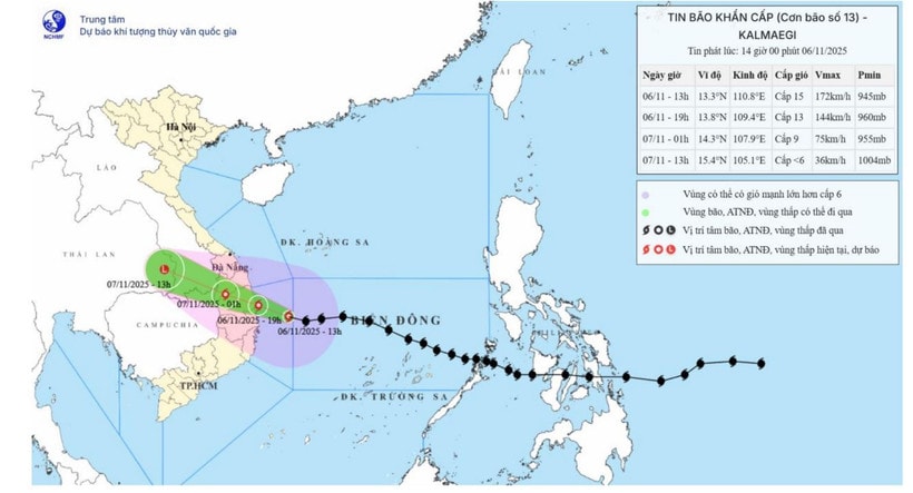
According to the National Center for Hydro-Meteorological Forecasting, at 2:00 p.m. on November 6, the center of storm No. 13 was at 13.3°N - 110.5°E, 150 km east-southeast of Quy Nhon.
The strongest wind near the storm center reached 183 km/h, moving west-northwest at 25-30 km/h. By 7 pm, storm No. 13 will approach the coastal area of Quang Ngai - Dak Lak, maintaining wind speed of level 13, gusting to level 17.
Natural disaster risk is warned at level 4 in the coastal area from Quang Ngai to Gia Lai and level 3 in neighboring areas such as Quang Tri, Da Nang and Khanh Hoa.
At sea, storm No. 13 brought strong winds of level 15 and waves of up to 11m high, causing the sea from Quang Ngai to Khanh Hoa to shake violently. Sea levels in many coastal areas such as Dung Quat, Hoi An, Quy Nhon and Tuy Hoa rose by 1-1.5m.
Central provinces have been warned of the risk of flooding, coastal erosion and waves inundating low-lying residential areas. Boats and coastal aquaculture areas have been ordered to suspend operations until storm No. 13 weakens.
On land, winds from storm No. 13 have increased sharply in provinces from Da Nang to Dak Lak. Many places recorded winds of level 9-13, especially the eastern areas of Quang Ngai and Gia Lai, which are directly affected, with winds capable of destroying fragile houses.
It is forecasted that from November 6 to 7, rainfall in the Central Highlands will reach 200-400mm, with some places exceeding 600mm. Hue, Khanh Hoa and Lam Dong areas may also receive up to 300mm of rain.
Heavy rains caused by storm No. 13 will gradually decrease from November 8, but there is still a risk of flash floods and landslides in mountainous areas.
Around dawn on November 7, storm No. 13 is forecast to weaken into a tropical depression as it moves further inland. However, the storm's circulation is still causing heavy rain in many provinces in the Central and North Central regions.
Experts warn people not to be complacent, because the circulation after storm No. 13 can cause thunderstorms, tornadoes and strong gusts of wind even after the storm's eye has left the area.
 mạnh cấp 15, giật trên cấp 17, tâm bão hướng vào Quảng Ngãi - Đắk Lắk")

 đã đi vào vùng biển phía Đông khu vực giữa Biển Đông")

