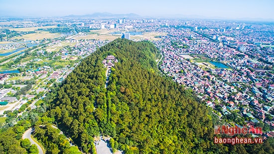
Spring arrives on Quyết Mountain.
(Baonghean) - Mount Quyet is situated in a unique location that the ancients called "flat land creating mountains." To the north, Vinh city resembles five outstretched fingers; to the southwest, vast fields and villages stretch out; and to the east, the emerald green Lam River flows into the Hoi Thong estuary. The mountain embodies the shapes of a dragon, a unicorn, a tortoise, and a phoenix, formerly known as the Four Sacred Animals. It is this poetic yet majestic, strong yet gentle beauty of the mountain that has captivated the attention of countless poets and military strategists throughout history.
 |
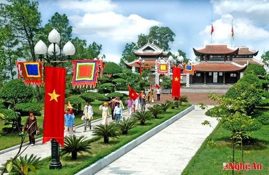
| The temple dedicated to King Quang Trung on Quyết Mountain. Photo: PV |
Reading Bui Huy Bich's poem in classical Chinese, "Spring View of Dung Quyet Mountain," my heart resonates with enchanting sounds and images: The mountain emerges through the misty rain, sails glide gently into the shadows of trees at the mountain's edge, the royal pavilion sits amidst the smooth, flower-strewn stone steps, the birdsong echoes from the cave through the grassy village—truly, "A single glance at the verdant scenery is incomparable to painting." The author not only gazes from afar but also ascends to the summit to admire the view, letting his soul wander in the vast expanse of sea and sky. Raising the vantage point simultaneously elevates the beauty of the mountain, merging it into the swirling, boundless expanse of the earth and sky, creating a unique poetic painting.
Enjoy the tranquil scenery and the sea creatures.
Long Xuyen full of Pisces
(Silently gazing at the beautiful scenery of the sky and sea, a sight that never ends)
The Lam River flows turbulently, merging with the Pisces River.
In the book "Genealogy of the Hung Kings," an ancient Vietnamese-language book still preserved at the National Library, there is a passage that reads: "Loc Tuc was the son of Emperor Nghi and the grandson of Emperor Minh. When he ascended the throne, he took the title Kinh Duong Vuong, named the country Xich Quy, and established his capital at Thu Linh." Thu Linh, also known as Ngan Hong in Vietnamese, is located on the southern bank of the Lam River. Kinh Duong Vuong had fortresses and ramparts built on the mountain on the northern bank of the river, observing a vast area from Cau Cam to Cua Lo and Cua Hoi, and able to detect both land and naval forces from afar. That mountain is none other than Quyet Mountain...
To protect the capital of Van An, in 722 Mai Thuc Loan (Mai Hac De) ordered the construction of a defensive line along the Hong Linh mountain range and on Quyet mountain to fight the invading Tang dynasty army. Many fierce battles took place here… In 1003, King Le Dai Hành personally led troops into Nghe An to supervise the continued digging of the Da Cai canal connecting the Ke Gai river with the Lam river. To facilitate the command of canal digging and the construction of Chinh Duc port (Cau Duoc area, Vinh city today), the king established his headquarters at the foot of Quyet mountain, after which this area developed and prospered…
In 1039, King Ly appointed Crown Prince Ly Nhat Quang as the governor of Nghe An province. He stopped in the Quyet mountain region and had the Vong Hai Dai (Sea View Tower) built on the highest peak of the mountain to observe the East Sea, detect enemy ships entering the Hoi Thong estuary, and established a Thuy (Water) fort near Con Rua (Turtle) islet at the foot of the mountain to control the waterway on the Lam River. A strong standing army named Dung Quyet was stationed on the Canh Phuong peak, hence the mountain's name, Dung Quyet Son (Dung Quyet Mountain).
During the Tran and Le dynasties, Grand Tutor Tran Quang Khai established a defensive line to block the Mongol invaders. General Nguyen Xi (awarded the title of Founding Hero by King Le Loi, and changing his surname to Le Xi) established his headquarters in the Quyet mountain region. Nguyen Xi also relied on the mountainous terrain to build fortifications, digging tunnels in the mountains to serve as weapons depots and stockpiles of military supplies in case the Ming invaders returned… Notably, in 1788, King Quang Trung chose this place to establish his imperial capital, calling it Phuong Hoang Trung Do. The King clearly saw that this area (Yen Truong commune, Chan Loc district - formerly known as Thanh Vinh) had "spacious terrain and bright atmosphere... truly a beautiful place to establish a capital." Establishing the capital here meant "a balanced distance, capable of controlling both the North and South" (Edict sent to La Son scholar Nguyen Thiep). The imperial palace had two layers of walls, called the outer and inner walls. The outer wall was a quadrilateral with a circumference of 2,820 m, while the inner wall, built of laterite stone, had a circumference of 1,680 m, with a three-story dragon tower in the center.
Along with building the capital at Quyết Mountain, Quang Trung also ordered the construction of the Imperial Examination Hall and the Sùng Chính Library. The work was nearing completion, and the relocation of the capital was imminent, when in 1792 the King suddenly passed away. The Tây Sơn dynasty was destroyed by Gia Long, along with its fortifications and everything it had built. But Phượng Hoàng Trung Đô (Phoenix Central Capital) will forever go down in history, affirming the cultural vision and brilliant strategic eye of this national hero.
 |
| Landscape of the Quang Trung King's temple (Dung Quyet mountain, Vinh City). Archival photo. |
During the two sacred wars of resistance against the French and the Americans, Mount Quyet served both as a protective fortress and a launching pad for the soldiers and people of the Red City to achieve glorious victories. This is where the Phuc Viet Association – the first revolutionary organization in Nghe Tinh – was founded. The Association contacted the youth organization in Guangzhou, changed its name to the Vietnam Revolutionary Comrades Association, and later to the Tan Viet Revolutionary Party, abbreviated as the Tan Viet Party. Active members of this organization spread out to factories and workers' neighborhoods, forming the core of the movement to establish the Indochinese Communist Party in 1930 and the Nghe Tinh Soviet Uprising.
The US launched a war of destruction against North Vietnam, and Vinh - Ben Thuy was a strategically important area for supporting the battlefield in the South. It was a key target for enemy air attacks. To protect the important structures of Vinh city, a large air defense force, including anti-aircraft artillery, missiles, naval forces, and self-defense militia, was deployed in high density on both banks of the river and in several nearby locations. Mount Quyet became a steel wall, a strategically important position for the city's defense line.
The workers of the Vinh Power Plant dismantled the turbine and moved it into a natural cave with a wide entrance and a height of over 3 meters, installing and operating it for many years. Even when the plant was attacked, electricity continued to shine, serving production and the war effort. This cave also served as a living and working place for hundreds of workers and self-defense forces at the Ben Thuy ferry crossing, who stayed day and night transporting troops, vehicles, artillery, weapons, food, and supplies to support the Southern battlefield. The 4th Military Region Command directed the engineering corps to dig several more tunnels on the eastern and southeastern slopes of the mountain to place ground-based artillery capable of firing at enemy ships in the East Sea. A 37mm anti-aircraft company of the 280th Regiment dragged the artillery to the mountaintop to set up a position, and in the very first battle on August 5, 1964, coordinated operations to shoot down one F4D and damage two others. This was the first jet aircraft shot down over North Vietnam. At the end of the war, in the Ben Thuy - Nui Quyet area alone, 6 collectives and 5 individuals were honored as Heroes of the Armed Forces…
Perhaps the sacred spirit of the mountains and rivers, the indomitable spirit of our ancestors, has gathered here, so that Mount Quyet, after being devastated by thousands of tons of bombs and reduced to barren rocks, now rises up lush with pine trees? This species of tree, with its enduring roots that never move (Nguyen Trai), spreads its shade ever more abundantly, making Dung Quyet even more poetic and majestic; allowing us to rediscover the echoing birdsong and the verdant scenery, difficult to depict in the poetry of the scholar Bui Duong Lich. The parking area near the mountainside of the former logistics company of the 280th Regiment, now leveled to become a volleyball court, still bears the marks of the overhanging craters carved into the mountain for vehicles to hide in, and the cracked trenches left by American bombs. The chimney of the power plant still stands tall, and the iron pillars of the old ferry landing remain. They are not just relics, but witnesses to a glorious historical era of this land that "rose up first."
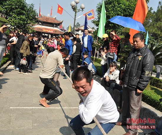 |
| Tug-of-war at the King Quang Trung Temple Festival. Photo: PV |
Looking at these examples, one can truly appreciate the immense efforts of the people of Vinh City, rising from deep wounds and starting from nothing. Building on the traditions of their ancestors, rekindling pride in their land of outstanding people and resilience in the struggle for national construction and defense, and with the support of the province and the central government, the city has focused its efforts and intellect on formulating a development strategy for Vinh, both present and future. Large-scale projects are continuously being built. At the foot of the mountain in the southeast, the Ben Thuy Bridge 1 and 2 stand majestically across the Lam River. And Mount Quyet has been transformed into a forest park, an ideal destination. In 1995, construction began on 450 stone steps leading up the mountain. In 1998, to commemorate the 210th anniversary of Phuong Hoang Trung Do - Vinh, investment was made in leveling and paving a road to the top of the flagpole. At the summit, a magnificent octagonal watchtower was built, right on the site of the ancient Ly Nhat Quang's sea-viewing tower.
A new spring has arrived on Quyết Mountain. My heart was filled with emotion as I joined the throngs of people admiring the Temple of King Quang Trung, built on the mountain overlooking the Lam River. The magnificent temple is constructed of fine wood, with stone and foundation stones sourced from Nhồi Mountain in Thanh Hóa, paving bricks from Hà Tây (Hanoi), and roof tiles and decorative tiles from An Lão, Hải Phòng. The main gate has two levels and eight roofs. The roofs are all curved in the style of Nguyễn Dynasty architecture, meticulously crafted with exquisite carvings. The construction was made possible through the efforts of the local community combined with the skillful hands of a large team of Vietnamese craftsmen, resulting in a structure that is both grand and magnificent, yet solemn and ancient.
The construction project brought back to me the magnificent image of Mount Quyet as described in the poems of ancient poets. Significantly, it not only enhances the beauty and sacredness of the mountain but also has educational value, transforming Mount Quyet - Vinh City into an attractive cultural tourism destination, drawing an increasing number of domestic and international tourists. Every spring, Vinh City organizes a festival, flag procession, and ceremonies to honor the national hero Quang Trung and the brave martyrs who sacrificed their lives on this mountain peak. Along with the large-scale projects already underway, Vinh is moving towards becoming a regional economic and cultural center in the North Central region; towards a prosperous, civilized, and modern city in the future.
Dinh Thanh Quang
| RELATED NEWS |
|---|

