The tropical depression has strengthened into Typhoon No. 9 with gusts reaching level 10.
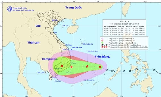
(Baonghean.vn) - At 2 PM, the typhoon's center was located at approximately 11.4 degrees North latitude; 115.5 degrees East longitude, about 130km east of Song Tu Tay Island (part of the Truong Sa archipelago).
According to the Central Meteorological and Hydrological Forecasting Center, at 2 PM this afternoon (November 22),The tropical depression has strengthened into a typhoon, the 9th typhoon of 2018.
 |
| The path and location of Typhoon No. 9. Photo: National Center for Hydro-Meteorological Forecasting. |
At 2 PMThe storm's center is located at approximately 11.4 degrees North latitude and 115.5 degrees East longitude, about 130km east of Song Tu Tay Island (part of the Spratly Islands). The strongest winds near the storm's center are at level 8 (60-75km/hour).escalating 10The radius of strong winds (level 6, gusting to level 8) extends approximately 100km from the storm's center.
Forecast for the next 24 hours,The storm is moving west-northwest at approximately 15 km/h and is likely to intensify. By 13:00 on November 23rd, the storm's center will be located at approximately 11.5 degrees North latitude and 112.8 degrees East longitude, about 340 km east of the coast of the South Central provinces. The strongest winds near the storm's center will be at level 9 (75-90 km/h).level 11The radius of strong winds (level 6, gusting to level 8) extends approximately 180km from the storm's center.
Due to the influence of the storm, the central and southern parts of the South China Sea (including the waters around the Spratly Islands) are experiencing stormy weather, strong winds of force 6-7, reaching force 8-9 near the storm's center, with gusts up to force 11; the sea is very rough.Level of natural disaster risk: level 3.
Dangerous areas in the South China Sea over the next 24 hours.: (Strong winds of level 6 or higher) from latitude 9.5 to 13.5 degrees North; east of longitude 110.5 degrees East.
Over the next 24 to 48 hours,The storm is moving westward at approximately 15 km/h and is likely to intensify. By 13:00 on November 24th, the storm's center will be located at approximately 11.4 degrees North latitude and 109.5 degrees East longitude, over the sea off the coast of provinces from Binh Dinh to Binh Thuan. The strongest winds near the storm's center will be at force 9-10 (75-100 km/h).level 12 gust.Level of natural disaster risk: level 3.
Over the next 48 to 72 hours,The storm is moving westward at approximately 10 km/h, making landfall in the South Central provinces. By 13:00 on November 25th, the storm's center was located at approximately 11.6 degrees North latitude and 107.5 degrees East longitude, directly over the South Central and Southern Central Highlands provinces. The strongest winds near the storm's center reached level 8 (60-75 km/h).level 10 surge.Level of natural disaster risk: level 3.

