Typhoon No. 10 approaches Hoang Sa Island, with gusts reaching level 10.
According to the National Center for Meteorological and Hydrological Forecasting, at 4:00 AM on November 3rd, the typhoon's center was located at approximately 15.0 degrees North latitude and 115.5 degrees East longitude, about 450km east-southeast of the Hoang Sa archipelago.
strongest wind speedarea near the center of the stormThe storm is at level 8 (60-75 km/h), with gusts up to level 10. The radius of strong winds from level 6, with gusts from level 8 and above, is approximately 140 km from the storm's center.
The forecast for the next 24 hours indicates the storm will move in a west-southwest direction at a speed of 10 km per hour. By 4:00 AM on November 4th, the storm's center will be located at approximately 14.3 degrees North latitude and 113.2 degrees East longitude, about 290 km south-southeast of the Hoang Sa (Paracel) Islands.Wind powerThe strongest winds near the storm's center will reach force 8-9 (60-90 km/h), with gusts up to force 11.
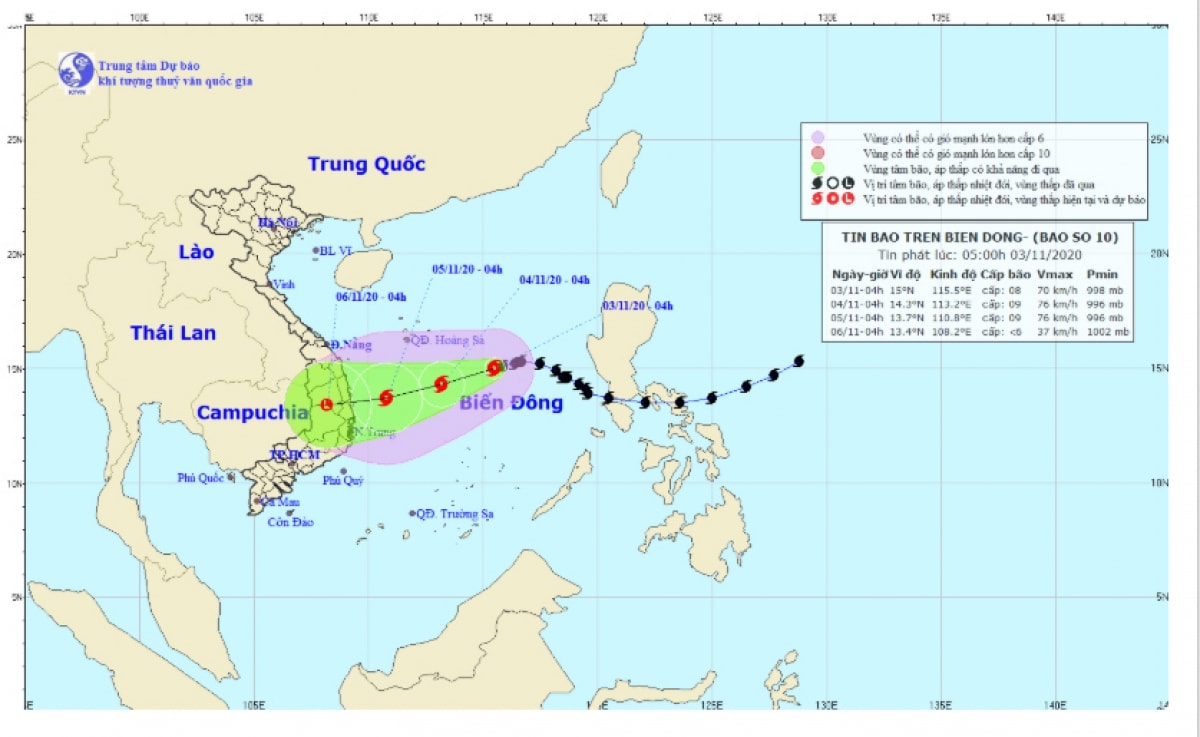
The danger zone due to the storm in the South China Sea over the next 24 hours (strong winds of level 6 or higher, gusts of level 8 or higher): from latitude 12.5 to 17.0 degrees North; from longitude 111.5 to 120.0 degrees East. All vessels operating in this danger zone are at high risk of being affected by strong gusts of wind.
Over the next 24 to 48 hours,The storm is moving.The storm was moving mainly in a west-southwest direction at approximately 10 km/h. By 4:00 AM on November 5th, the storm's center was located at approximately 13.7 degrees North latitude and 110.8 degrees East longitude, about 160 km east of the area between Quang Ngai and Khanh Hoa provinces. The strongest winds near the storm's center were at level 9 (75-90 km/h), with gusts up to level 11.
Over the next 48 to 72 hours, the storm will move mainly west-southwest at approximately 10 km/h, making landfall in the provinces from Quang Ngai to Khanh Hoa and gradually weakening into a tropical depression, then further weakening into a low-pressure area. By 4:00 AM on November 6th, the center of the low-pressure area will be located at approximately 13.4 degrees North latitude; 108.2 degrees East longitude. The strongest winds near the center of the low-pressure area will decrease to below level 6 (below 40 km/h).
Level of natural disaster risk due to storms: Level 3./.

