Storm Son-Tinh with level 11 winds causing strong thunderstorms is approaching the coast.
(Baonghean.vn) - At 7:00 a.m. on July 18, the center of the storm was located at about 18.8 degrees North latitude; 109.5 degrees East longitude, in the area west of Hainan Island, about 390km east of the mainland provinces from Thai Binh to Ha Tinh. The strongest wind near the center of the storm was level 9 (75-90km/hour), gusting to level 11.
Forecast for the next 24 hours, the storm moves quickly to the West, about 25-30km per hour;Around this evening (July 18), the storm center with strong winds of level 8, gusting to level 10 will directly affect coastal areas of provinces from Thai Binh to Ha Tinh.The storm will then move inland and weaken into a tropical depression..
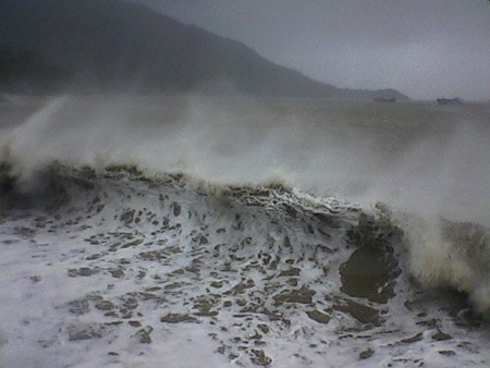 |
| Around this evening (July 18), the storm center with strong winds of level 8, gusting to level 10 will directly affect coastal areas of provinces from Thai Binh to Ha Tinh. Illustrative photo |
At 7:00 a.m. on July 19, the center of the tropical depression was at about 19.2 degrees North latitude; 104.0 degrees East longitude, on the Vietnam - Laos border area. The strongest wind near the center of the tropical depressionlevel 6 strong(40-50km/h),level 8 jerk. The range of strong winds of level 6, gusting to level 8 or higher is about 50km from the center of the tropical depression.
Due to the influence of the storm, in the North East Sea area (including the waters of Hoang Sa archipelago), there are strong thunderstorms; in the West of the North East Sea area today there are strong storm winds of level 8-9,level 11; very rough seas. In the Gulf of Tonkin, there are strong winds of level 6, then increasing to level 7, near the eye of the storm, strong winds of level 8,level 10, waves 3-5m high; rough seas. Coastal areas of the Northern Delta and North Central Coast are likely to see sea levels rise above tidal levels by about 0.5m; waves 2-4m high; rough seas.
From this afternoon (July 18), coastal areas of Thai Binh, Nam Dinh, Ninh Binh, Thanh Hoa, Nghe An and Ha Tinh provinces will have winds gradually increasing to level 6-7, and near the storm's eye, level 8.level 10.
Forecast for the next 24 to 36 hours, the tropical depression continued to move west, weakening and gradually dissipating.Storm disaster risk level: level 3.
From noon today, in the provinces of the Northern Delta and midlands, the provinces from Thanh Hoa to Quang Binh will have very heavy rain and it will last until about July 20 (common rainfall 100-300mm/period, some places over 350mm).
Warning: From July 18-20, a flood will appear in the upper reaches of the Red-Thai Binh river system, Hoang Long river, and rivers from Thanh Hoa to Ha Tinh. The flood peak on the Da river, Thao river, Hoang Long river, and the upper reaches of rivers in Thanh Hoa, Nghe An, and Ha Tinh will reach level 1-2, the Buoi river (Thanh Hoa) will be above level 2; the lower reaches of the main rivers in Thanh Hoa, Nghe An, and Ha Tinh will be below level 1.
High risk of landslides and flash floods in mountainous areas of the northern provinces and provinces from Thanh Hoa to Ha Tinh (details in flood bulletins, flash flood and landslide warnings).Warning level of natural disaster risk due to floods, flash floods, landslides: level 2.
From noon this afternoon (July 18) to the night of July 19, Nghe An will have very heavy rain.
Due to the influence of the strong tropical convergence zone combined with the western edge of the circulation of storm No. 3, last night (July 17), in the provinces of the North and Central Central Coast, there was rain, moderate rain, some places had heavy rain to very heavy rain with common rainfall of 10-30mm, some places over 50mm such as: Tinh Gia (Thanh Hoa) 47mm, Quy Chau (Nghe An) 51mm, A Luoi (Thua Thien-Hue) 63mm, Tam Ky (Quang Nam) 104mm,...
Currently (July 18):The tropical convergence zone with its axis passing through the North Central region is strongly active, connecting with storm No. 3, located at 7:00 a.m. this morning at about 18.8 degrees North latitude, 109.5 degrees East longitude.
Forecast:From noon this afternoon (July 18) to the night of July 19, due to the influence of storm No. 3, in the plains and midlands of the North, the provinces of Hoa Binh, Son La, Thanh Hoa, Nghe An, Ha Tinh, Quang Binh will have very heavy rain (common rainfall 150-200mm/period; in Thanh Hoa, Nghe An, Ha Tinh, Quang Binh 200-350mm/period).
From July 19-20, heavy rain is likely to spread to the northern mountainous provinces and the Northwestern region (very heavy rain is concentrated in Vinh Phuc, Phu Tho, Tuyen Quang, Yen Bai, Son La, with rainfall ranging from 100-200mm/period, with some places exceeding 250mm).
Weather in Hanoi area:From this afternoon until July 19, there will be moderate to heavy rain, and in some places very heavy rain and thunderstorms. During thunderstorms, there is a high possibility of tornadoes, whirlwinds and strong gusts of wind.
The Central Highlands and the South are affected by the strong southwest monsoon, so in the next 2-3 days there will continue to be rain, moderate rain, heavy rain and thunderstorms in some places (rain is concentrated in the afternoon and night); during thunderstorms there is a very high possibility of tornadoes, whirlwinds and strong gusts of wind.
Disaster risk level due to heavy rain: level 1; Thanh Hoa, Nghe An, Ha Tinh, Hoa Binh, Son La, Phu Tho, Tuyen Quang, Yen Bai provinces: level 2.


.jpg "Nghệ An: Lễ khai giảng đặc biệt ở xã biên giới bị thiệt hại nặng nề nhất sau bão số 3")


: cách Nghệ An khoảng 185km về phía Đông Đông Nam")
.jpg "Gần 5 tỷ đồng hỗ trợ học sinh Nghệ An bị ảnh hưởng bão số 3")