The East Sea is about to welcome the 10th storm
It is forecasted that on the morning of September 13, low pressure will enter the East Sea and strengthen into a storm in this area.
The National Center for Hydro-Meteorological Forecasting said that the Northwest Pacific region has a strong storm internationally named Talim and a tropical depression near the east coast of the Philippines.
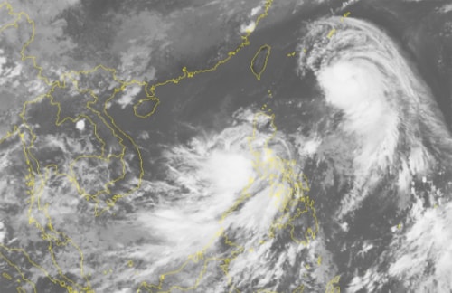 |
Satellite image of tropical depression clouds in the eastern region of the Philippines at 12:30 on September 12. |
It is forecasted that in the next 2-3 days, storm Talim will continue to strengthen, possibly reaching level 15 and heading north, approaching China.
The tropical depression is forecast to pass over the central region of the Philippines and enter the East Sea on the morning of September 13, strengthening into a storm. This will be the 10th storm to appear in the East Sea this year.
The storm circulation will cause showers and thunderstorms in the eastern and southern parts of the East Sea, including the Truong Sa archipelago, from today. From the night of September 12, the eastern part of the East Sea will have strong winds of level 6-7, and the winds will increase in the early morning and tomorrow.level 8 when the tropical depression strengthens into a storm.
The dangerous sea area identified in the next 24 hours will be north of the 13th parallel and east of the 115th longitude. Ships should avoid entering this area.
According to the meteorological agency, the 2017 storm season has about 13-15 storms and tropical depressions active in the East Sea, more than the average of previous years (12 storms). Of these, 3-4 storms will make landfall, directly affecting the Vietnamese mainland, concentrated in the Central region./.
According to VNE
| RELATED NEWS |
|---|


.png "Chính phủ thông qua báo cáo nghiên cứu tiền khả thi dự án đường bộ cao tốc từ xã Hưng Nguyên (Nghệ An) đến biên giới Lào")
.jpg "Hội Nhà báo Nghệ An tổ chức hành trình về nguồn, tri ân tại đất lửa Quảng Trị")

