Typhoon No. 5 is forecast to bring heavy rain to Nghe An province from September 18 to 20.
(Baonghean.vn) - Due to the influence of the strengthening continental cold high pressure system and the northern edge of the circulation of typhoon No. 5, it is forecast that from September 18 to the morning of September 20, the North Central region will experience moderate to heavy rain, with some areas experiencing very heavy rain and thunderstorms.
According to information from the North Central Meteorological and Hydrological Station,at 7:00 AM on September 16thThe storm's center is located at approximately 13.2 degrees North latitude and 117.6 degrees East longitude, about 750km southeast of the Paracel Islands. The strongest winds are near the center.stormLevel 8 (60-75 km/h)level 10 surge.
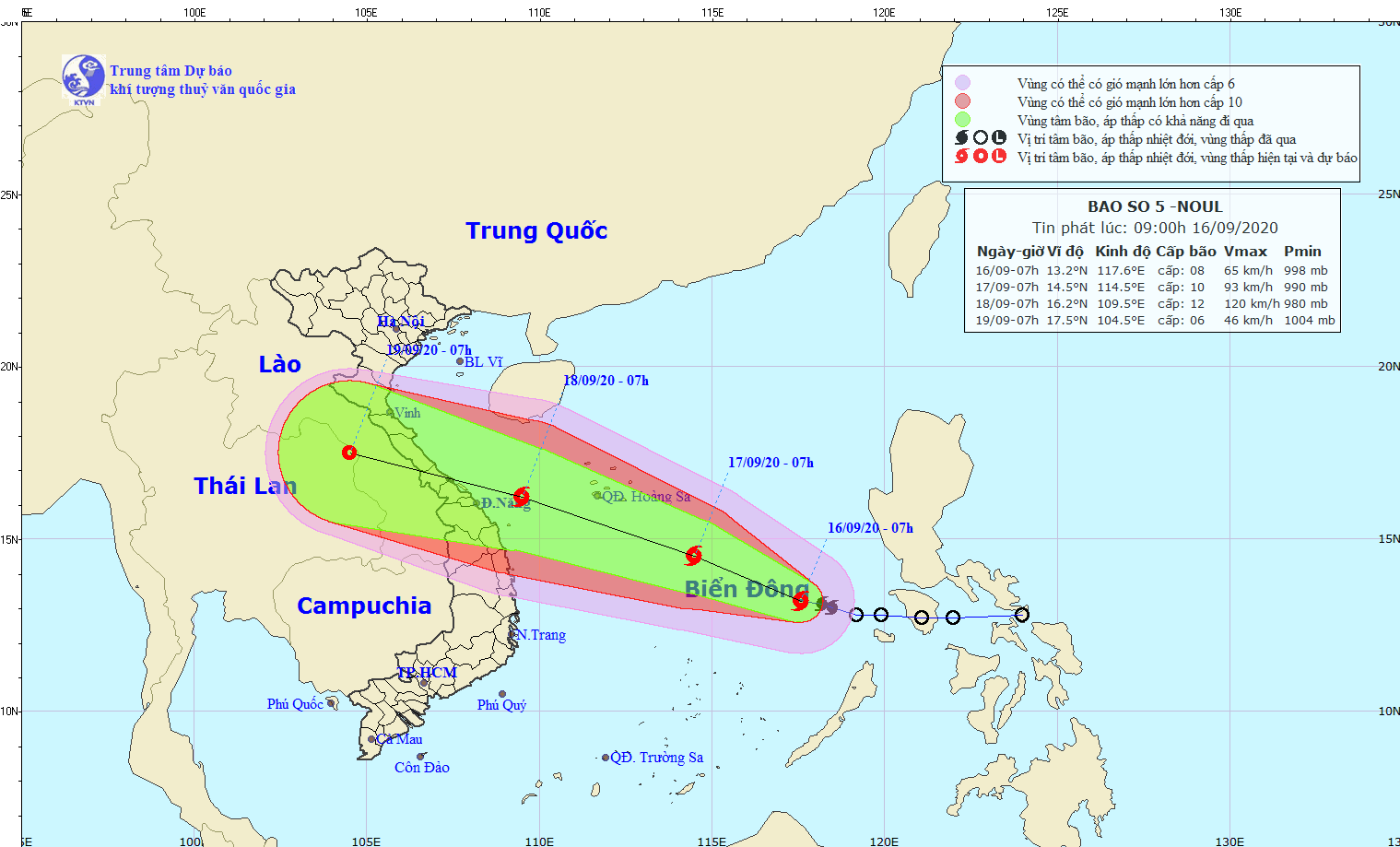 |
| Image showing the path of Typhoon No. 5, updated at 9:00 AM on September 16th. Photo: North Central Vietnam Meteorological and Hydrological Station. |
Forecast for the next 24 hours,The storm is moving in a west-northwest direction at approximately 15 km/h and is likely to intensify. By 07:00 on September 17th, the storm's center will be located at approximately 14.5 degrees North latitude; 114.5 degrees East longitude, about 350 km southeast of the Hoang Sa (Paracel) Islands. The strongest winds near the storm's center will be at force 9-10 (75-100 km/h).level 12 gust.
Dangerous areas in the South China Sea over the next 24 hours.(Strong winds from level 6, gusts from level 8 and above)North of latitude 11.0 degrees North; East of longitude 112.5 degrees East. All vessels operating in this dangerous zone are at high risk of being affected by strong winds and cyclones.
Due to the influence of the storm, the central area of the South China Sea is experiencing strong winds of level 7, with winds near the storm's center reaching level 8, later increasing to levels 9-10, with gusts up to level 12. The sea is very rough.
Over the next 24 to 48 hours,The storm is moving in a west-northwest direction at a speed of 20 km/h and is likely to intensify. By 7:00 AM on September 18th, the storm's center will be located at approximately 16.2 degrees North latitude and 109.5 degrees East longitude, in the sea off the coast of provinces from Quang Tri to Quang Nam. The strongest winds near the storm's center will be at level 11-12 (100-135 km/h).level 14.
Level of natural disaster risk: Level 3.
Due to the influence of the strengthening continental cold high pressure system and the northern edge of the circulation of typhoon number 5,North Central region from September 18th to the morning of September 20th,moderate to heavy rainIn some places, there was very heavy rain and thunderstorms.The total rainfall during this period is likely to reach 150 - 350 mm; in the southern part of the region, some areas may receive over 400 mm.
During thunderstorms, there is a possibility of tornadoes, lightning, hail, and strong gusts of wind; localized heavy rainfall in a short period of time poses a high risk.flash floodLandslides occur in the midland and mountainous regions.

