Cold air continues to cause severe cold, with some places in the North and North Central regions below 3 degrees Celsius.
(Baonghean.vn) - According to the National Center for Hydro-Meteorological Forecasting, this severe cold spell is likely to last until around January 4, 2019; in the mountainous areas of the North, there is a possibility of frost.
 |
| Frost appeared in Muong Long valley, Ky Son district in the early morning of December 20, 2017. Photo: Archive |
Early this morning (December 31):Strong cold air has caused widespread cold in the North and North Central regions. The temperature at 1am this morning was measured in some places such as: Mau Son (Lang Son) -0.6 degrees; Sa Pa (Lao Cai) 3.5 degrees; Tam Dao (Vinh Phuc) 4.1 degrees; Trung Khanh (Cao Bang) 3.5 degrees, Hanoi 10.0 degrees,... In the Gulf of Tonkin, there was strong northeast wind at level 6-7, gusting to level 8.
Forecast:Today and tonight, strong cold air continues to cause widespread cold in the North and North Central regions with the lowest temperature commonly 8-11 degrees Celsius; in mountainous areas 4-7 degrees Celsius; in high mountainous areas below 3 degrees Celsius.
Warning:This severe cold spell is likely to last until around January 4, 2019; frost is likely to occur in the mountainous areas of the North.
In the Gulf of Tonkin, the northern and central East Sea (including the waters of the Hoang Sa archipelago), the northeast wind is at level 6-7, gusting to level 8-9; rough seas. In the waters off the Central and Southern regions, there is strong northeast wind at level 6, gusting to level 8, rough seas. In particular, the waters from Quang Ngai to Binh Thuan (including Phu Quy island district) due to the combined influence of the northern edge of the low pressure area that is likely to strengthen into a tropical depression, from tonight the wind will gradually increase to level 6-7, gusting to level 9-10, rough seas.
NEWS OF WIDESPREAD HEAVY RAIN IN THE CENTRAL REGION
Early this morning (December 31):In the provinces from Ha Tinh to Phu Yen, there continues to be rain, some places have moderate rain, heavy rain (rainfall in the past 6 hours from 7:00 p.m. on December 30 to 1:00 a.m. on December 31) in some places such as: Ky Anh (Ha Tinh) 12mm, Nam Dong (Thua Thien Hue) 24mm, Tam Ky (Quang Nam) 23mm,
Forecast:Due to the influence of cold air, provinces from Ha Tinh to Quang Tri have rain, some places have moderate rain, heavy rain (common rainfall 20-50mm/24 hours).
Due to the influence of disturbances in the East wind zone at the northern edge of the low pressure trough with an axis at about 7-10 degrees North latitude, from this afternoon and tonight (December 31), in the provinces from Thua Thien Hue to Binh Thuan, there will be heavy to very heavy rain (common rainfall 70-150mm/24 hours, some places over 200mm/24 hours). After that, moderate and heavy rain is likely to last until about January 3-4, 2019.
LOW PRESSURE AREA OVER THE EAST SEA IS LIKELY TO STRENGTHEN INTO A TROPHIC DEPRESSION
At 1:00 a.m. on December 31, the center of the low pressure area is located at about 7.0-8.0 degrees North latitude; 112.9-113.9 degrees East longitude, about 180km South Southwest of Truong Sa Island (Truong Sa archipelago).
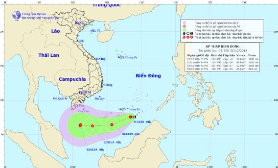 |
| Path and location of the tropical depression. Photo: National Center for Hydro-Meteorological Forecasting |
Forecast for the next 24 hours,The low pressure area moves in the West Southwest direction, traveling 10-15km per hour and is likely to strengthen into a tropical depression. At 01:00 on January 1, 2019, the center of the tropical depression was at about 6.4 degrees North latitude; 110.7 degrees East longitude, about 190km south of Huyen Tran (Truong Sa archipelago). The strongest wind near the center of the tropical depression is level 6 (40-50km/hour).level 8 jerk.
Dangerous areas in the East Sea in the next 24 hours(strong wind level 6, gust level 8 or higher): the entire North and Central East Sea area (north of latitude 7.0 degrees North).Disaster risk level due to tropical depression in the South China Sea: level 3.
Over the next 24 to 48 hours,The tropical depression is moving mainly in a westerly direction, traveling 10km per hour and is likely to strengthen. At 01:00 on January 2, the center of the tropical depression was at about 6.2 degrees North latitude; 107.9 degrees East longitude, about 420km southeast of Ca Mau cape. The strongest wind near the center of the tropical depression is level 6-7 (40-60km/hour).level 9.
Over the next 48 to 72 hours,The tropical depression is moving mainly in a westerly direction, about 5-10km per hour and has the potential to strengthen into a storm.
Due to the influence of cold air, in the Gulf of Tonkin and the northern and central East Sea (including the waters of the Hoang Sa archipelago), there will be strong northeast winds of level 6-7, gusting to level 8-9; rough seas and likely to last for the next 3-4 days.
In the sea off the Central and Southern regions, there will be strong northeast winds of level 6, gusting to level 8; rough seas. From tonight (December 31), due to the influence of cold air combined with the northern edge of the low pressure area that is likely to strengthen into a tropical depression, the sea off the coast of the provinces from Quang Ngai to Binh Thuan (including Phu Quy island district) will have winds gradually increasing to level 6-7, gusting to level 9-10; rough seas.


