Central region has widespread heat wave above 37 degrees Celsius for a long time
(Baonghean.vn) - Due to the influence of the southern edge of the low pressure trough with an axis at about 22-24 degrees North latitude, connecting with the low pressure area in the West that is developing towards the East, combined with the foehn wind effect that tends to gradually become stronger, from June 12, heat waves will occur widely in the Northern and Central Central provinces.
Yesterday (June 11),Heat waves have occurred in some places in the Northern provinces and the mountainous areas in the West of the North and Central Central regions with the highest temperature of 34-36 degrees, some places above 36 degrees such as: Thai Binh 36.4 degrees, Nam Dinh and Hoi Xuan (Thanh Hoa) 36.2 degrees, Tinh Gia (Thanh Hoa) 37.2 degrees, Con Cuong (Nghe An) 36.6 degrees, Nam Dong (Thua Thien-Hue) 36.5 degrees, Quang Ngai 37.1 degrees.
 |
| In the Central provinces, the heat will continue. Photo: Archive |
Forecast:Due to the influence of the southern edge of the low trough with an axis at about 22-24 degrees North latitude, connecting with the low pressure area in the West that is developing towards the East, combined with the foehn wind effect that tends to become stronger, from today (June 12), heat waves will occur widely in the Northern Delta, the Northern and Central Central provinces with the highest temperature commonly 35-37 degrees, some places over 37 degrees; from tomorrow (June 13), heat waves will appear widely in Son La, Hoa Binh and the northeastern provinces. The time with temperatures above 35 degrees is from 12-16 hours.
Warning:The widespread heat wave in the North will last until June 13, from June 14 the heat wave will gradually ease; In the Central provinces the heat wave will continue to last.Heat wave disaster risk level: level 1
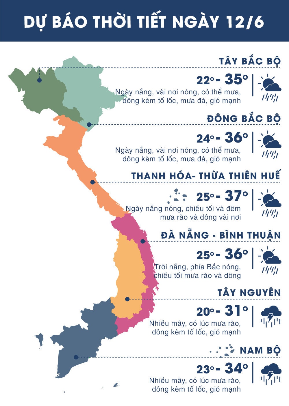 |
| Temperature on June 12, 2018 in regions across the country. Source: zing.vn |
WARNING FOR STRONG WINDS AND HIGH WAVES IN THE SOUTHERN COAST:
Currently (June 12):Due to the influence of the southern edge of the low pressure trough with an axis at about 22-24 degrees North latitude combined with the southwest wind zone in the South with medium to strong intensity, in the Central and Southern East Sea (including the sea area of Truong Sa archipelago), the sea area of Binh Thuan-Ca Mau, the sea area of Ca Mau-Kien Giang and the Gulf of Thailand there will be showers and thunderstorms.
Forecast:Due to the influence of the southwest monsoon with medium to strong intensity, the Central and Southern East Sea area (including the Truong Sa archipelago), the Binh Thuan-Ca Mau sea area has strong southwest winds of level 5, sometimes level 6, gusting to level 8. Waves are 2-4m high. Rough seas.
The Central and Southern East Sea (including the Truong Sa archipelago), the sea from Binh Thuan - Ca Mau, Ca Mau - Kien Giang and the Gulf of Thailand continue to have showers and heavy thunderstorms. During thunderstorms, there is a possibility of tornadoes and strong gusts of wind.Disaster risk level: level 1.


.jpg "Nông dân Nghệ An tất bật thu hoạch dưa giải nhiệt")